
Harding Township, New Jersey facts for kids
Quick facts for kids
Harding Township, New Jersey
|
|
|---|---|
|
Township
|
|

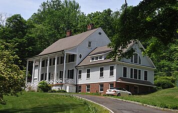
Hartley Farms
|
|

Location of Harding Township in Morris County highlighted in red (right). Inset map: Location of Morris County in New Jersey highlighted in orange (left).
|
|

Census Bureau map of Harding Township, New Jersey
|
|

Harding Township, New Jersey
Location in Morris County, New Jersey

Harding Township, New Jersey
Location in New Jersey

Harding Township, New Jersey
Location in the United States
|
|
| Country | |
| State | |
| County | |
| Incorporated | September 1, 1922 |
| Named for | Warren G. Harding |
| Government | |
| • Type | Township |
| • Body | Township Committee |
| Area | |
| • Total | 20.57 sq mi (53.28 km2) |
| • Land | 20.05 sq mi (51.94 km2) |
| • Water | 0.52 sq mi (1.34 km2) 2.51% |
| Area rank | 140th of 565 in state 9th of 39 in county |
| Elevation | 367 ft (112 m) |
| Population
(2020)
|
|
| • Total | 3,871 |
| • Estimate
(2023)
|
3,891 |
| • Rank | 417th of 565 in state 36th of 39 in county |
| • Density | 193.0/sq mi (74.5/km2) |
| • Density rank | 506th of 565 in state 39th of 39 in county |
| Time zone | UTC−05:00 (EST) |
| • Summer (DST) | UTC−04:00 (EDT) |
| ZIP Code | |
| Area code(s) | 973 |
| FIPS code | 3402729700 |
| GNIS feature ID | 0882195 |
Harding Township is a community in Morris County, New Jersey. It's known for its beautiful, large country estates and a quiet, rural feel. The township is located in the Passaic Valley region, which is part of the larger New York Metropolitan area.
Harding Township was officially created on September 1, 1922. It was formed from parts of what was then called Passaic Township (now Long Hill Township). The people living there voted to create the new township on May 9, 1922.
In 2020, about 3,871 people lived in Harding Township. This was a small increase from the 2010 population of 3,838. The township is home to the historic villages of New Vernon and Green Village. It also has a private community called Mount Kemble Lake, which started as a summer vacation spot in the 1920s.
The New York Times has called Harding Township "one of the most restrictive and elegant" places to live in New Jersey. It's known for being a very wealthy community. Many large country estates have been kept in families for generations, showing the history and wealth of the area. Some of these estates are even listed on the National Register of Historic Places.
Contents
History of Harding Township
Ancient Lake and Early Settlers
Long ago, after a huge ice sheet called the Wisconsin Glacier melted, a giant lake named Glacial Lake Passaic covered this area. About 15,000 to 11,000 years ago, this lake was about 30 miles (48 km) long and 10 miles (16 km) wide! The lake eventually drained when the Passaic River found its way through a blockage.
Today, the Great Swamp is what's left of that ancient lake bed. Parts of the swamp are still in Harding Township. Once the lake was gone, the higher areas became forests. Native Americans used these lands for hunting, fishing, and farming. When the Dutch colonists arrived, the land belonged to the Lenape tribes. Later, British colonists moved them further west.
Farming and Rural Life
For a long time, much of Harding was a farming community. Its history goes back to the early 1700s. The area stayed very rural because major roads, canals, and railroads were built elsewhere. For almost 200 years, the open fields and rolling hills showed that it was mostly used for farming. People raised cattle, grew crops, and had orchards. Farmers also used the Great Swamp and the nearby Watchung Mountains for wood. Small villages like Green Village, Logansville, New Vernon, and Pleasantville were the centers of this farming life.
Why Harding Township Was Formed
Later, wealthy people from Manhattan and Newark started buying farms in the area. They made the old farmhouses bigger and created beautiful landscapes. The idea to create Harding Township came from local property owners. They wanted to keep their community rural and prevent too much new development.
The township was created in 1922 from the northern part of what was then Passaic Township. It was named after the President at the time, Warren G. Harding.
In 1928, estate owners created the New Vernon Neighborhood Restrictive Agreement. This was a voluntary agreement where they promised to keep their land rural. This helped protect over 1,000 acres (4 km²) in Harding Township. It also influenced later zoning laws, which helped keep the landscape natural and open to this day.
Geography of Harding Township
Harding Township covers about 20.57 square miles (53.28 km²). Most of this area is land, with a small part being water.
Communities within Harding
The township includes several small communities. A part of Green Village and all of New Vernon are located here. Both of these places started as colonial settlements even before the American Revolution. The main government offices for Harding Township are in New Vernon.
Other small communities and places in the township include Baileys Mill, Glen Alpin, Jockey Hollow Park, Mount Kemble Lake, and Pleasantville.
Neighboring Towns
Harding Township shares borders with several other towns. In Morris County, it borders Mendham Township to the west, Madison to the northeast, Chatham Township to the east, Morris Township to the north, and Long Hill Township to the southeast. It also borders Bernardsville and Bernards Township in Somerset County to the south.
Population in Harding Township
| Historical population | |||
|---|---|---|---|
| Census | Pop. | %± | |
| 1930 | 1,206 | — | |
| 1940 | 1,565 | 29.8% | |
| 1950 | 1,970 | 25.9% | |
| 1960 | 2,683 | 36.2% | |
| 1970 | 3,249 | 21.1% | |
| 1980 | 3,236 | −0.4% | |
| 1990 | 3,640 | 12.5% | |
| 2000 | 3,180 | −12.6% | |
| 2010 | 3,838 | 20.7% | |
| 2020 | 3,871 | 0.9% | |
| 2023 (est.) | 3,891 | 1.4% | |
| Population sources: 1930 1940–2000 2000 2010 2020 |
|||
2010 Census Information
In 2010, the census counted 3,838 people living in Harding Township. There were 1,474 households, with 1,126 of them being families. Most of the people (94.14%) were White. About 2.66% were Asian, and 0.99% were Black or African American. About 3.49% of the population was Hispanic or Latino.
The average household had 2.60 people, and the average family had 3.00 people. About 24% of the population was under 18 years old, and 21% were 65 years or older. The median age was 48.9 years.
Education in Harding Township
Local Schools
The Harding Township School District serves students from pre-kindergarten through eighth grade. All these students attend the Harding Township School. In the 2021–22 school year, there were 299 students and 41.2 teachers, meaning there were about 7.3 students for every teacher.
High School Education
For high school, students from Harding Township attend Madison High School in Madison. This is part of a special agreement with the Madison Public Schools. In the 2021–22 school year, Madison High School had 839 students and 69.6 teachers.
Historic District
The Tempe Wick Road–Washington Corners Historic District is a special area that is important for its history. It covers about 353 acres (1.4 km²) in Harding Township and Mendham Township. This district includes Tempe Wick Road and several other smaller roads. Tempe Wick Road is named after a person called Temperance Wick.
This historic district was added to the National Register of Historic Places in 2000. It's important because of its old buildings and its connection to military history. The district has 44 buildings, 6 sites, 10 structures, and 4 objects that are considered historically important.
-
Peter Kemble House
-
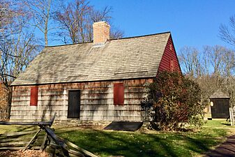
Tempe Wick House at Jockey Hollow


Transportation
_in_Harding_Township,_Morris_County,_New_Jersey.jpg)
Roads and Highways
As of 2010, Harding Township had about 47.82 miles (76.96 km) of roads. The township itself maintains 26.48 miles (42.62 km) of these roads.
Interstate 287 is the biggest highway that goes through Harding Township. However, there are no exits for I-287 directly within the township. The closest exits are just outside the township in nearby Bernards Township and Morris Township. U.S. Route 202 is the main highway that provides local access to Harding Township.
Public Transportation
Many people who live in Harding commute to jobs in Manhattan, New York City. There are private van services that take people to Jersey City or Hoboken. From there, they can take ferries or the PATH train across the Hudson River to Lower Manhattan. Many residents also use train stations in nearby towns like Madison and Morristown to get to Midtown Manhattan.
Notable People

Many interesting people have lived in or are connected to Harding Township. Here are a few:
- William O. Baker (1915–2005), a former head of Bell Labs, a famous research company.
- James J. Barry Jr. (born 1946), a politician who served in the New Jersey government.
- Michelle Cesan (born 1991), a field hockey player who competed for the United States in the 2012 Summer Olympics.
- Ray Chambers (born 1942), a special envoy for the United Nations.
- Steve Conine (born 1972/73), a co-founder of the online store Wayfair.
- Ned Crotty (born 1986), a professional lacrosse player.
- Marcellus Hartley Dodge Sr. (1881–1963), lived at Hartley Farms, a large estate in New Vernon.
- Peter Frelinghuysen Jr. (1916–2011), a politician who served in the U.S. House of Representatives.
- Rodney Frelinghuysen (born 1946), another politician who served in the U.S. House of Representatives.
- Justin Gimelstob (born 1977), a professional tennis player.
- Kerry Kittles (born 1974), a former professional basketball player.
- Eric Mangini (born 1971), a former head coach for the New York Jets football team.
- Bart Oates (born 1958), a former professional football player for the New York Giants.
- Morgan Pearson (born 1993), a professional triathlete who won a silver medal at the 2020 Summer Olympics.
- William E. Simon (1927–2000), who was the United States Secretary of the Treasury.
- Greeley Wells (1920–2014), a businessman and former mayor of Harding Township.
See also
 In Spanish: Municipio de Harding (Nueva Jersey) para niños
