Bernardsville, New Jersey facts for kids
Quick facts for kids
Bernardsville, New Jersey
|
||
|---|---|---|
|
Borough
|
||
|
||
|
||
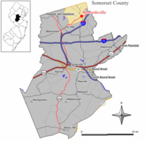
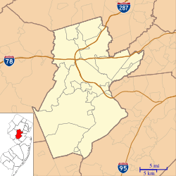
Location of Bernardsville in Somerset County highlighted in yellow (right). Inset map: Location of Somerset County in New Jersey highlighted in black (left).
|
||
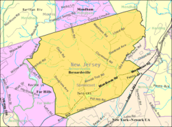
Census Bureau map of Bernardsville, New Jersey
|
||
| Country | ||
| State | ||
| County | ||
| Incorporated | April 29, 1924 | |
| Named for | Sir Francis Bernard, 1st Baronet | |
| Government | ||
| • Type | Borough | |
| • Body | Borough Council | |
| Area | ||
| • Total | 12.91 sq mi (33.44 km2) | |
| • Land | 12.84 sq mi (33.24 km2) | |
| • Water | 0.07 sq mi (0.19 km2) 0.58% | |
| Area rank | 184th of 565 in state 9th of 21 in county |
|
| Elevation | 682 ft (208 m) | |
| Population
(2020)
|
||
| • Total | 7,893 | |
| • Estimate
(2023)
|
7,837 | |
| • Rank | 295th of 565 in state 13th of 21 in county |
|
| • Density | 614.9/sq mi (237.4/km2) | |
| • Density rank | 428th of 565 in state 18th of 21 in county |
|
| Time zone | UTC−05:00 (Eastern (EST)) | |
| • Summer (DST) | UTC−04:00 (Eastern (EDT)) | |
| ZIP Code |
07924
|
|
| Area code(s) | 908 | |
| FIPS code | 3403505590 | |
| GNIS feature ID | 0885159 | |
| Website | ||
Bernardsville is a borough located in Somerset County, in the state of New Jersey. It's known as the northernmost borough in the county. Bernardsville is a historic and well-off community where many people live and travel to work in New York City. It's part of the larger New York metropolitan area.
In 2020, about 7,893 people lived in Bernardsville. This was a small increase from the 7,707 people counted in 2010. The town's name is often pronounced "BER-nards-ville," not "Ber-NARDS-ville."
Bernardsville became an official borough on April 29, 1924. It was created from parts of Bernards Township. The borough was named after Sir Francis Bernard, 1st Baronet, who was a governor of New Jersey before the Revolutionary War. A part of Bernardsville, the Olcott Avenue Historic District, was added to the National Register of Historic Places in 2009 because of its important history.
Contents
History of Bernardsville
Bernardsville was once a part of Bernards Township and was called Vealtown. In 1840, it was renamed Bernardsville. The new name honored Sir Francis Bernard, 1st Baronet, who was the governor of New Jersey from 1758 to 1760. Bernardsville is in the northern part of Somerset County. It is about 12 miles south of Morristown.
Revolutionary War Times
During the American Revolutionary War, General Charles Lee and his troops stopped in Vealtown. This was around December 12-13, 1776. General Lee was captured by the British nearby on December 13. The Vealtown Tavern, now called the John Parker Tavern, was a regular stop for soldiers. This was especially true during the winter of 1779–1780, when the army was camped in Morristown.
Growth and Development
After the American Civil War, many wealthy people from New York City started coming to the area. They first visited in the summer, then many moved here permanently. The men often worked in New York City, while their families spent summers in Bernardsville.
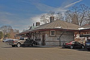
The Gladstone Branch railroad line was built through Bernardsville in 1872. This train line was very important for the town's growth. It allowed people to travel directly to Penn Station in New York City. This meant that men who built large homes in Bernardsville could travel to the city for work every day. Bernardsville became its own town, separate from Bernards Township, in 1924.
In 2020, the Bernardsville Library joined the MAIN Library System. This system connects libraries in Morris, Hunterdon, Somerset, and Warren counties. The Bernardsville Library officially joined on January 11, 2021.
Olcott Avenue Historic District
|
Olcott Avenue Historic District
|
|
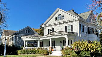
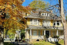
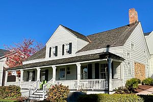
Colonial Revival style house on Olcott Avenue
|
|
| Location | Portions of Olcott, Childsworth, and Highview Avenues, and Church Street |
|---|---|
| Area | 28 acres (11 ha) |
| Architect | Henry Janeway Hardenbergh |
| Architectural style | Tudor Revival, Colonial Revival, Craftsman |
| NRHP reference No. | 09000940 |
| Significant dates | |
| Added to NRHP | November 20, 2009 |
The Olcott Avenue Historic District is a 28-acre historic area. It includes parts of Olcott, Childsworth, and Highview Avenues, and Church Street. This district is special because it shows how a middle-class neighborhood grew in the early 1900s. It was added to the National Register of Historic Places on November 20, 2009. It's important for its architecture, town planning, and history of education.
The neighborhood has many well-built homes from the early 20th century. These houses show different styles from that time. The streets and houses have changed little since the roads were paved around 1916.
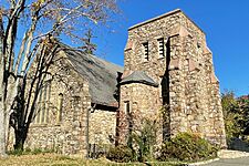
Olcott Avenue is named after Frederic P. Olcott. He was a banker and helped many people in New York. In 1905, Olcott paid for the first high school in the area. The school building is made of stone and has a Tudor Revival style. It was designed by architect Henry Janeway Hardenbergh. He also designed the Bernardsville United Methodist Church.
Geography and Climate
Bernardsville covers about 12.91 square miles. Most of this area is land, with a small amount of water.
Some smaller communities and places within Bernardsville include Blaziers Corner, Mine Brook, and Somersetin.
Bernardsville shares borders with several other towns. These include Bernards Township to the east, Far Hills to the southwest, and Peapack-Gladstone to the west. It also borders Harding Township, Mendham Borough, and Mendham Township in Morris County.
Weather in Bernardsville
Bernardsville has a climate with cool to cold winters and warm to hot, humid summers. Higher parts of the town get more snow in winter. Summer is the wettest season, with many afternoon thunderstorms. Winter is the driest time of year.
| Climate data for Bernardsville, New Jersey | |||||||||||||
|---|---|---|---|---|---|---|---|---|---|---|---|---|---|
| Month | Jan | Feb | Mar | Apr | May | Jun | Jul | Aug | Sep | Oct | Nov | Dec | Year |
| Record high °F (°C) | 74 (23) |
76 (24) |
86 (30) |
94 (34) |
99 (37) |
101 (38) |
104 (40) |
105 (41) |
105 (41) |
92 (33) |
84 (29) |
73 (23) |
105 (41) |
| Mean daily maximum °F (°C) | 38 (3) |
41 (5) |
50 (10) |
61 (16) |
72 (22) |
80 (27) |
85 (29) |
83 (28) |
76 (24) |
64 (18) |
54 (12) |
42 (6) |
62 (17) |
| Mean daily minimum °F (°C) | 18 (−8) |
20 (−7) |
27 (−3) |
36 (2) |
46 (8) |
56 (13) |
61 (16) |
60 (16) |
52 (11) |
40 (4) |
31 (−1) |
23 (−5) |
39.2 (4.0) |
| Record low °F (°C) | −16 (−27) |
−12 (−24) |
−1 (−18) |
16 (−9) |
26 (−3) |
34 (1) |
44 (7) |
38 (3) |
29 (−2) |
12 (−11) |
5 (−15) |
−10 (−23) |
−16 (−27) |
| Average precipitation inches (mm) | 3.59 (91) |
2.84 (72) |
3.94 (100) |
4.09 (104) |
4.33 (110) |
4.35 (110) |
4.83 (123) |
3.98 (101) |
4.26 (108) |
4.21 (107) |
3.59 (91) |
3.84 (98) |
47.85 (1,215) |
| Source: Weather.com (Monthly Averages for Bernardsville, NJ) | |||||||||||||
Population Information
| Historical population | |||
|---|---|---|---|
| Census | Pop. | %± | |
| 1930 | 3,336 | — | |
| 1940 | 3,405 | 2.1% | |
| 1950 | 3,956 | 16.2% | |
| 1960 | 5,515 | 39.4% | |
| 1970 | 6,652 | 20.6% | |
| 1980 | 6,715 | 0.9% | |
| 1990 | 6,597 | −1.8% | |
| 2000 | 7,345 | 11.3% | |
| 2010 | 7,707 | 4.9% | |
| 2020 | 7,893 | 2.4% | |
| 2023 (est.) | 7,837 | 1.7% | |
| Population sources:1930 1940–2000 2010 2020 |
|||
In 2010, there were 7,707 people living in Bernardsville. There were 2,685 households, with many families. Most of the people (91.38%) were White. About 3.27% were Asian, and 0.88% were Black or African American. People of Hispanic or Latino background made up 11.72% of the population.
About 28.6% of the people were under 18 years old. About 12.2% were 65 years or older. The average age in Bernardsville was 41.1 years.
Schools and Education
Students in Bernardsville attend public schools in the Somerset Hills Regional School District. This district also serves students from Far Hills and Peapack-Gladstone. Students from Bedminster also attend the high school.
The district has three schools:
- Marion T. Bedwell Elementary School: for students in Pre-Kindergarten through 4th grade.
- Bernardsville Middle School: for students in 5th through 8th grade.
- Bernards High School: for students in 9th through 12th grade.
A board of education with nine elected members (and one appointed member from Bedminster) manages the district. They make decisions about school policies and how the schools are run. Bernardsville has six of the nine elected seats on the board.
The School of Saint Elizabeth is a private Catholic school in Bernardsville. It teaches students from Pre-Kindergarten through 8th grade. It is part of the Roman Catholic Diocese of Metuchen.
Getting Around Bernardsville
Bernardsville has many miles of roads. The town maintains most of them. Some roads are managed by Somerset County or the New Jersey Department of Transportation.
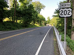
The main roads in Bernardsville are U.S. Route 202 and County Route 525. The major highway Interstate 287 is also very close to the borough.
Public Transportation
NJ Transit offers train service from the Bernardsville station. This station is on the Gladstone Branch and Morristown Line. You can take trains to places like Hoboken Terminal, Newark Broad Street station, Secaucus Junction, and Penn Station in Midtown Manhattan.
Lakeland Bus Lines also provides bus service during rush hour. This bus goes from Bedminster to the Port Authority Bus Terminal in Midtown Manhattan.
Famous People from Bernardsville
Many interesting people have lived in or are connected to Bernardsville. Here are a few:
- Walt Ader (1913–1982), a race car driver.
- Brooke Astor (1902–2007), a well-known socialite and philanthropist.
- Roger Bart (born 1962), an actor.
- Sir Francis Bernard (1712–1779), a British colonial governor.
- C. Ledyard Blair (1867–1949), an important investment banker.
- Roger Bodman (born 1952), a politician and political expert.
- Philip Capice (1931–2009), an Emmy Award-winning TV producer.
- Tommy Dorsey (1905–1956), a famous jazz musician.
- Forrest F. Dryden (1864–1932), a president of Prudential Insurance Company.
- John Fairfield Dryden (1839–1911), who founded Prudential Insurance Company and was a U.S. Senator.
- Ernest Duncan (1916–1990), a mathematician.
- Marc Ecko (born 1972), a fashion designer.
- Millicent Fenwick (1910–1992), a U.S. Congresswoman.
- Zach Feuer (born 1978), an art dealer.
- Guy Gabrielson (1891–1976), a politician who led the Republican National Committee.
- Alina Habba (born 1984), a lawyer.
- Henry Janeway Hardenbergh (1847–1918), a famous architect.
- Jacqueline Kennedy Onassis (1929–1994), a former First Lady of the United States.
- Elmer Matthews (1927–2015), a lawyer and politician.
- Andrew McCarthy (born 1962), an actor.
- Katie Meyler (born 1982), recognized as a Time Person of the Year for her work with Ebola Fighters.
- Bill Moyers (born 1934), a journalist.
- Bob Nash (1892–1977), an early football player.
- Frederic P. Olcott (1841–1909), a financier and helper of communities.
- George B. Post (1837–1913), an architect and early developer of Bernardsville.
- Donald Roebling (1908–1959), an inventor.
- John A. Roebling II (1867–1952), an engineer and giver to charities.
- Carol Stiff, a women's basketball executive at ESPN.
- Suzanne Scott (born 1965/66), CEO of Fox News.
- Meryl Streep (born 1949), a famous actress.
- Mike Tyson (born 1966) and Robin Givens (born 1964), a boxer and an actress.
- Jean Villepique, an actress.
See also
 In Spanish: Bernardsville para niños
 | Leon Lynch |
 | Milton P. Webster |
 | Ferdinand Smith |


