Hazeldean, Queensland facts for kids
Quick facts for kids HazeldeanQueensland |
|||||||||||||||
|---|---|---|---|---|---|---|---|---|---|---|---|---|---|---|---|

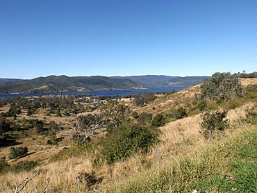
D'Aguilar Range and Somerset Dam along Esk Kilcoy Road, 2015
|
|||||||||||||||
| Population | 326 (2021 census) | ||||||||||||||
| • Density | 3.756/km2 (9.73/sq mi) | ||||||||||||||
| Postcode(s) | 4515 | ||||||||||||||
| Area | 86.8 km2 (33.5 sq mi) | ||||||||||||||
| Time zone | AEST (UTC+10:00) | ||||||||||||||
| Location | |||||||||||||||
| LGA(s) | Somerset Region | ||||||||||||||
| State electorate(s) | Nanango | ||||||||||||||
| Federal Division(s) | Blair | ||||||||||||||
|
|||||||||||||||
Hazeldean is a quiet rural area in the Somerset Region of Queensland, Australia. It's known for its beautiful natural surroundings, especially Lake Somerset, which is a big lake created by a dam. In 2021, about 326 people called Hazeldean home. It's a peaceful place to live or visit, with lots of nature to explore.
Contents
Exploring Hazeldean's Nature
Hazeldean is a really scenic place, especially because of Lake Somerset. This huge lake covers the eastern part of the area. Lake Somerset was formed when the Somerset Dam was built across the Stanley River.
The western part of Hazeldean is higher up and covered mostly by natural plants and trees. The land between the lake and these mountains has homes spread out, giving people lots of space.
National Parks and Forests
Hazeldean is home to some important natural areas.
Deer Reserve National Park
The Deer Reserve National Park is located in the south-west of Hazeldean. It includes a mountain called Mount Brisbane, which stands 684 metres (2,244 ft) above sea level. This national park covers a large area of 3,228 hectares (7,980 acres). It also stretches into nearby areas like Fulham, Cooeeimbardi, and Somerset Dam.
Deer Reserve State Forest
In the north-west of Hazeldean, you'll find the Deer Reserve State Forest. This forest has two notable mountains: Mount Goonneringerringgi at 495 metres (1,624 ft) and Mount McConnel at 277 metres (909 ft). The state forest is 2,894 hectares (7,150 acres) in size. It also extends into neighbouring places like Gregors Creek and Fulham.
Hazeldean's Past
Hazeldean has an interesting history, especially concerning its schools and how the area changed because of the Somerset Dam.
Early School Days
The Stanley River Provisional School first opened its doors on January 26, 1898. It started with 24 students. In 1909, it became the Stanley River State School. This school was located on the eastern side of the Esk Kilcoy Road.
Moving Timber
In the 1920s, a special 300-meter long tramway was built in Hazeldean. This tramway helped move timber down a very steep mountain slope. It made it easier to transport wood from the top of the mountain to the bottom.
School Relocation and Closure
When the Somerset Dam was being built, parts of Hazeldean were expected to be flooded. Because of this, the Stanley River State School had to be moved to higher ground in 1951. A new, larger piece of land was chosen for the school further south on the Esk Kilcoy Road. The school buildings, including the teacher's house, were moved to this new spot.
However, the number of students dropped to just 12, and the school eventually closed on December 31, 1973. A few years later, on July 9, 1975, the school buildings found a new purpose. They became the Stanley River Field Study Centre, which later changed its name to the Stanley River Environmental Education Centre in 1990.
Who Lives in Hazeldean
The number of people living in Hazeldean has changed over the years.
- In 2011, there were 267 people living in Hazeldean.
- By 2016, the population was 262 people.
- In the most recent count in 2021, the population of Hazeldean grew to 326 people.
Learning in Hazeldean
While Hazeldean doesn't have regular schools for everyday classes, it does have a special place for learning about nature.
Environmental Education Centre
The Stanley River Environmental Education Centre is a unique outdoor learning center. It's located at 3856 Esk-Kilcoy Road. This center helps students learn about the environment and outdoor activities.
Nearby Schools
For everyday schooling, children in Hazeldean usually go to nearby towns. The closest primary school is Kilcoy State School in Kilcoy. For high school, students can attend Kilcoy State High School, also in Kilcoy, or Toogoolawah State High School in Toogoolawah.
Things to Do in Hazeldean
Hazeldean offers some great spots for outdoor activities, especially around Lake Somerset.
Boat Ramps
If you want to get out on Lake Somerset, there are two boat ramps available off Kirkleigh Road:
- Kirkleigh North boat ramp
- Kirkleigh South boat ramp
These boat ramps are managed by an organization called Seqwater.
Lake Somerset Holiday Park
For those looking to stay and enjoy the area, the Lake Somerset Holiday Park is a great option. It's a large park right on the edge of Somerset Dam. The park offers different types of places to stay, including cabins and camping spots. It's a perfect place to relax and enjoy the beautiful lake.
 | John T. Biggers |
 | Thomas Blackshear |
 | Mark Bradford |
 | Beverly Buchanan |


