Hinsdale, Montana facts for kids
Quick facts for kids
Hinsdale, Montana
|
|
|---|---|
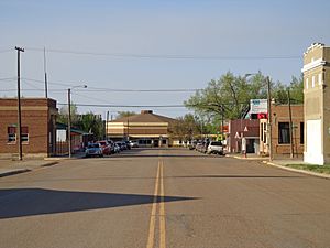
Montana Street looking North from Highway 2
|
|
| Nickname(s):
"The Best Little Town in the Milk River Valley"
|
|
| Country | United States |
| State | Montana |
| County | Valley |
| Government | |
| • Type | Unincorporated |
| Area | |
| • Total | 6.66 sq mi (17.25 km2) |
| • Land | 6.46 sq mi (16.75 km2) |
| • Water | 0.20 sq mi (0.50 km2) |
| Elevation | 2,126 ft (648 m) |
| Population
(2020)
|
|
| • Total | 193 |
| • Density | 29.85/sq mi (11.53/km2) |
| Time zone | UTC-7 (Mountain (MST)) |
| • Summer (DST) | UTC-6 (MDT) |
| ZIP code |
59241
|
| Area code(s) | 406 |
| GNIS feature ID | 2583816 |
Hinsdale is a small community in Valley County, Montana, United States. It's called an "unincorporated community" because it doesn't have its own local government like a city does. It's also a "census-designated place," which means the U.S. Census Bureau counts it as a specific area for population statistics.
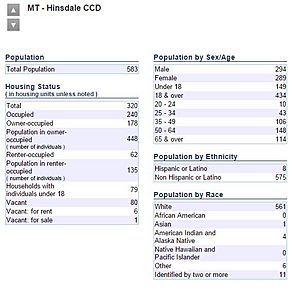
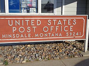
In 2010, about 217 people lived in the town itself. The wider community, including nearby areas, had a population of 583. Hinsdale is located along the Milk River and U.S. Highway 2. It also has its own post office with the ZIP code 59241.
Contents
Nearby Communities and Ghost Towns
Around Hinsdale, you can find smaller communities and even ghost towns. These places were settled during the Homestead Period, when people moved west to claim land.
History of Hinsdale
Native American tribes lived in the Hinsdale area for thousands of years. When Europeans arrived, they brought horses, which changed life on the prairies. As more settlers moved east, new tribes were pushed into this region.
The 1800s in Hinsdale
In May 1805, the Corps of Discovery (led by Lewis and Clark) reached the Milk River. They named it because the water looked "white," like tea with milk.
After the Corps of Discovery, the next big event was the arrival of Texas cattle. From 1866 to the late 1880s, cowboys brought cattle here to graze on the rich grass.
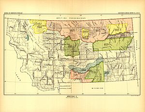
Various Native American tribes used and claimed this land. However, in 1888, a large area, including Hinsdale, was opened up for homesteading. This meant settlers could claim land to farm.
Hinsdale was officially created when the railroad came through. A post office opened in 1891. The first site, called Old Hinsdale, was about a mile and a half east of where the town is now. The current town site was owned by William Woolridge, who was the train station agent in 1897.
The first school in the community was built near the old Deegan ranch. The first school in the new Hinsdale was a log building on the current school grounds.
The 1900s in Hinsdale
Hinsdale once had two newspapers. The Montana Homestead ran from 1904 to 1912. The more famous Hinsdale Tribune was published from 1912 to 1971.
While many parts of the country were booming in the roaring twenties, Montana faced a severe drought. It was the only state to lose population during that time. Even though Hinsdale was far from the main Dust Bowl area, it still saw some dust storms during the Great Depression. Times were very hard, and most settlers who stayed survived by growing their own food.
The 1980s were also tough for farming across the country. Hinsdale suffered greatly during one of the worst droughts in its history.
The 2000s in Hinsdale
The 2010s brought unusual and record-breaking weather to Hinsdale. In the winter of 2010–2011, over 105 inches (267 cm) of snow fell in nearby Glasgow, Montana. This caused major flooding in the spring as the snow melted. Another flood happened later that spring because the ground was already soaked.
The summer of 2014 was very wet. After many small rainstorms, a huge storm hit in late August. Hinsdale received seven inches (18 cm) of rain in just three days. This caused the third "hundred-year flood" Hinsdale had seen in three years.
People of Hinsdale (Demographics)
| Historical population | |||
|---|---|---|---|
| Census | Pop. | %± | |
| 2020 | 193 | — | |
| U.S. Decennial Census | |||
In 2010, the Hinsdale community had 583 people living in 240 homes. There were 294 males and 289 females. The largest age group was people aged 50–64, with 148 individuals.
Geography and Climate
Hinsdale is located on the Milk River, just above the area that floods. A steep bank separates the town from a county park by the river. U.S. Highway 2 runs east and west on the south side of town, with train tracks next to it. South of town is the "south bench," which is a raised area of land. You can see different layers of soil and sandstone in this bench.
Long ago, Hinsdale was on the edge of an ancient inland sea in North America. As the Rocky Mountains grew, they eroded, and sediment filled this sea. Later, as the mountains got even taller, water started to wash away the deposited sediment. At one point, the Missouri River flowed north past Hinsdale, following what is now the Milk River Valley. It then turned north near Poplar and flowed into the Hudson Bay.
During the last ice ages, huge glaciers changed the landscape. The Missouri River was forced into its current path. The Milk River now flows through part of the Missouri's old riverbed. The glaciers also left behind many rocks and sediment.
Hinsdale has a semi-arid climate. This means it's usually dry, but not a true desert.
Schools in Hinsdale
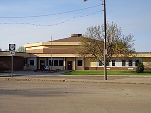
Hinsdale Public Schools teaches students from kindergarten through 12th grade. It's an important employer in the community, providing many teaching and support jobs. The school has two main sections: one for high school and one for elementary students. These sections are connected by the administration offices and the cafeteria. The school's mascot is the Raider, and its colors are maroon and white.
For sports, the high school has its own track and field team. For basketball and volleyball, Hinsdale teams up with Saco and Whitewater to form the North Country Mavericks. For football, they join with Glasgow.
Local Businesses and Jobs
The main type of work in Hinsdale is agriculture. Most farms and ranches here are family-owned and have been passed down through generations. Many of these businesses started when the area was first settled. Some, like the Canen Ranch and McColly Ranch, have been operating for over 100 years! The main products from this area include beef cattle, wheat, and animal feed.
The community also has a bank, a post office, a bar and cafe, a pottery shop, an ice cream shop, a gunsmith, a leathersmith, a beauty salon, a gas station, and other small businesses.
Transportation
The Amtrak train called the Empire Builder passes through Hinsdale. This train travels between Seattle/Portland and Chicago. However, it does not stop in Hinsdale. The closest train station is in Glasgow, which is about 29 miles (47 km) southeast.
Community Life
Hinsdale hosts a special Independence Day celebration every year on July 3rd and 4th. This event is called "Milk River Days" and started in 1976. It includes a rodeo, a street dance, a parade, a picnic, fireworks, and many other fun activities. There's also an "All School Reunion" every five years for former students of Hinsdale High School.
"Belly Bump" is a basketball tournament for alumni (former students) of Hinsdale High School. It started in 1978 and has been a tradition for many years.
See also
 In Spanish: Hinsdale (Montana) para niños
 | Stephanie Wilson |
 | Charles Bolden |
 | Ronald McNair |
 | Frederick D. Gregory |


