
History of Banbury facts for kids


Banbury is an old market town in Oxfordshire, England. It's located on the River Cherwell. The town is about 64 miles (103 km) northwest of London and 21 miles (34 km) north of Oxford. It has been a settlement for around 1,500 years!
Contents
General history
What's in a name?
The name "Banbury" comes from "Banna," a Saxon leader who built a fort here in the 500s. "Burgh" means settlement. So, it was "Banna's settlement." In the Domesday Book of 1086, it was called Banesberie.
Grimsbury, now part of Banbury, also has an old Saxon name. It means a strong place belonging to someone called 'Grim'. This might refer to the god Woden.
Early days: Romans and Anglo-Saxons

Banbury sits where two old roads met. One was Salt Way, used for moving salt. The other was Banbury Lane, which went through what is now Banbury High Street.
People first settled here in the British Iron Age, around 200 BC. In 2002, during building work, remains of circular buildings and pottery from that time were found. Later, a Roman villa was found nearby.
The Saxons arrived around the late 400s AD. In 556 AD, a battle happened here between the Anglo-Saxons and the local Romano-British people. Banbury grew during the Anglo-Saxon period, influenced by the Danes. In 1086, the Domesday Book recorded it as a large settlement owned by the Bishop of Lincoln.
The Saxons built Banbury on the west side of the River Cherwell. On the other side, they built Grimsbury, which became part of Banbury in 1889. Neithrop was another old area, first mentioned in the 1200s, and joined Banbury in 1889.
Medieval times
Banbury became rich in the Middle Ages because of its wool trade.
Banbury Castle was built in 1135 by Alexander, Bishop of Lincoln. It lasted until the English Civil War, when it was destroyed.
The Black Death in 1348–49 hit Banbury hard, likely killing half its people. But the town quickly recovered. For the next 300 years, its population stayed around 1,600.
For centuries, trading wool, ale, cakes, and cheese brought wealth. Wool was first mentioned in 1268. Cheese was made from the 1400s to the 1700s.
English Civil War

A fire partly destroyed Banbury in 1628. The town played a big role in the English Civil War. Oliver Cromwell is said to have planned the Battle of Edge Hill in an inn here. The town supported Parliament, but the castle was held by Royalist soldiers.
The Civil War helped Banbury's industries. Saltpetre (used for gunpowder) was dug nearby, and gunpowder was made in Banbury.
The war and two sieges damaged the town's economy. The castle's Royalist soldiers looted shops and houses. After the castle was defeated, it was partly blown up. In 1649, some soldiers from the New Model Army rebelled in Banbury. This became known as the Banbury mutiny.
From 1660 to 1834


Quaker missionaries were active in Banbury in the 1650s. A Quaker meeting house was built in 1664, and a new one in 1751.
In 1768, common lands were enclosed, changing how farming was done.
The Oxford Canal opened to Banbury in 1778. This brought cheap coal to the town. The canal was extended to Oxford by 1790. It brought much growth and is still popular today. The main boat yard, Tooley's Boatyard, is now a historic site.
In the 1800s, John Golby Rusher was a successful publisher in Banbury. He was known for his nursery rhyme books, which were sold all over the country.
From 1835 to 1912


In 1835, the Banbury Poor Law Union was formed, and a Workhouse was built. The town council took over running Banbury in 1836.
The Catholic St John the Evangelist Church was built in 1838.
Living conditions improved a lot in Victorian times. Many poor-quality cottages were removed. Banbury was growing, and Grimsbury expanded a lot between 1852 and 1881, with about 500 new houses built.
In 1889, Grimsbury and Nethercote officially became part of Banbury.
The first two railways came to Banbury in 1850. This helped Banbury become an even more important market town.
By 1900, Banbury had a population of 12,968. People's Park, which had been a private park, opened to the public in 1910.
From 1913 to 1946
In 1911, many houses were not fit for people to live in. The council started building new houses, like the Easington housing estate, which was one of the first slum clearance projects in the country. By 1933, the Ruscote housing estate was built.
Between 1931 and 1949, Banbury's population grew a lot. New houses were built in Easington, Neithrop, and other areas.
During World War I, the National Filling Factory, Banbury was built. It made filled shells. At its busiest, it employed over 4,000 people, many of them women. It closed in 1927. Some of this land is now used for industrial buildings near the M40 motorway.
During World War II, the Northern Aluminium Company (ALCAN) factory in Banbury expanded. It made 60% of Britain's wartime aluminium, processing metal from crashed planes.
After 1947


Banbury grew quickly in the 1930s and 1940s, with housing for people moving from nearby towns and London. More housing was built from 1945 to 1967. The town expanded into areas like Hardwick, Ruscote, Easington, and Bretch Hill.
In 1961, many older buildings in the town centre still lacked indoor toilets or hot water.
The Woodgreen swimming pool opened in 1939. It has been renovated several times and is still popular today.
Railways closed some lines in the 1960s, like the one from Buckingham to Banbury.
Banbury's growth sped up after the 1970s when the M40 motorway was completed. This made it faster to get to London and Birmingham. By 2001, the town's population was over 41,000.
Banbury used to have Western Europe's largest cattle market. Farmers would bring animals from far away to be sold. It closed in 1998, and new houses and a school were built there.
The town centre was renovated in 1981 and partly made pedestrian-friendly in 1991. The Hanwell estate was built between 2005 and 2006.
Future plans

There are plans to expand the Castle Quay Shopping Centre and add a cinema. Car parks are being rebuilt one by one.
There were plans to build more houses on farmland near Bretch Hill and Bodicote, but these have been put on hold. The Hanwell Fields Estate was built in 2008 and 2009, offering different types of housing.
Industry and commerce
Early businesses

In 1086, the Domesday Book listed three mills in Banbury. These mills were important for grinding grain.
Butchers' stalls were present in Banbury by 1438, showing early trade.
From 1639 to 1870
In 1639, Robert Vivers, a wool cloth merchant, owned Banbury Mill. A boat-building yard opened on the canal in 1790.
The arrival of the railway in 1850 boosted Banbury's role as a market town. The Cobb family's factory, which made "weaving, webbing, and horsecloths," operated from around 1700 until 1870.
The Canalside area became a hub for Banbury's agricultural, transport, and electrical engineering industries around 1850. The Britannia Works agricultural machinery plant was the biggest employer by 1861, with 380 workers. The Vulcan Foundry made industrial railway and steam engines.
At the Great Exhibition of 1851, Banbury firms showed off items like seed-drills, threshing machines, and various textiles.
The railways helped the agricultural implement manufacturing business grow. Sir Bernard Samuelson's Britannia Works made farming machines like reapers and lawn mowers. It was a major employer until the 1920s.
From 1869 to 1964


.png)


In 1870, the Banbury Tweed Co. took over a mill. This factory closed in 1932, ending a long history of wool and cloth trade in Banbury.
The economy slowed down from the 1870s to the 1920s. Many sawmills, timber yards, flour mills, and the tweed factory closed.
In 1917, the Oxfordshire Ironstone Railway opened, connecting an iron ore quarry to Banbury. Heavy clay and ironstone deposits are found around Banbury.
By the 1920s, Banbury's population growth had almost stopped. Its market and economic importance declined. The Britannia Works, which made farm machinery, closed in 1933.
However, in the 1930s, Banbury's economy became more varied. New factories opened, like Spencer Corsets Ltd. and Switchgear and Equipment Ltd. After World War II, more new industries came to Banbury. The council created the Southam Road Industrial Estate in the 1950s.
The Northern Aluminium Co. Ltd. (ALCAN) factory opened in 1931. It was a large factory that produced aluminium. The ALCAN facilities closed between 2006 and 2007.
After 1964
Another big employer is General Foods Ltd, now Kraft Foods. They make convenience foods like custard and instant coffee. The company moved to Banbury from Birmingham in 1965. Kraft Foods Banbury is a key part of the town's economy. Fine Lady Bakeries also expanded its operations in 1965.
The town centre was redeveloped in the 1970s. This led to the creation of the Castle Quay Shopping Centre in 1977.
Banbury has many shops in local centres and the town centre. There's a market on Thursdays and Saturdays, and a farmers' market once a month.
Kraft Foods, Banbury

Kraft Foods has a large food and coffee factory in the north of Banbury. It was built in 1964. It's sometimes still called General Foods, after the company that first owned it.
Industrial estates
The Tramway and Canalside industrial estates


The Tramway and Canalside industrial estates are built on land that once belonged to the Britannia Works. The Tramway estate is named after an old industrial tramway that ran between factories from around 1881 to 1935. Today, it's home to many businesses, including a bus depot and various shops.
Other industrial estates
The Southam Road Industrial Estate was set up in the mid-1950s. It attracted many industries, including General Foods (now Kraft Foods). This estate became a major economic hub for Banbury by the early 1970s.
Other industrial estates like Overthorpe and Wildmear were built in the 1960s, 70s, and 80s. Thorpe Way industrial estate also grew in the 1960s.
Farming
Banbury once had Western Europe's largest cattle market on Merton Street. It was a big part of Victorian life. In the late 1920s, the market moved to Grimsbury, close to the railway station. It officially closed in 1998 and was replaced by housing and a school.
Much of the farmland around Banbury has been developed for housing and other facilities over the years.
Recent economic changes


.png)
The economic downturn around 2008 led to some shops closing in Banbury. However, many of these places have since reopened under new names or as different businesses. For example, a Tesco Express opened in a former pub, and a Next store replaced an SCS branch.
New businesses and a recruitment drive by Prodrive have helped reduce unemployment in recent years.
Local government
In 1554, Banbury was given a royal charter. This made it a legal borough, governed by aldermen.
Until 1889, the Town Council mainly handled local justice, police, markets, and keeping municipal property in order. After 1889, their duties expanded to include street repairs, cleaning, lighting, sewerage, health, and public parks. They also became responsible for elementary education after the Education Act 1902.
The town's gas, electricity, and water supplies were managed by private companies until 1947, when the council bought the water company.
Banbury kept its borough council until 1974. Then, it became part of the Cherwell District Council. A new town council was set up in 2000.
Notable mayors
Banbury has had many mayors since the position was created in 1607.
- Thomas Webb was the first Mayor of Banbury in 1607.
- Lyne Spurrell was the first female mayor in 1838.
- Richard Goffe served the longest, for five non-consecutive years.
- William James Harding had the longest continuous term, from 1914 to 1918.
- Surinder Dhesi was the town's first Asian mayor in 2004.
- Some roads and housing estates are named after former mayors.
Major schools
Wykham Park Academy
Wykham Park Academy, formerly Banbury School, is a large school with about 1,650 students, including a sixth form. It is located in the Easington area of Banbury. The school specializes in Humanities.
Blessed George Napier Roman Catholic School
Blessed George Napier Roman Catholic School is on Addison Road. It serves Catholic children from across North Oxfordshire.
North Oxfordshire Academy
North Oxfordshire Academy is a school in Banbury that opened in September 2007. It replaced the former Drayton School. The school is run by the United Learning Trust.
Water treatment and sanitation


In the mid-1800s, Banbury started to get organized water supply and sewage systems. The Banbury Water Co. was formed in 1854 to get water from the River Cherwell, clean it, and pump it to a reservoir.
Banbury has had three sewage works since the mid-1800s. The first two closed around 1910.
By 1900, the Banbury Water Co. supplied water to almost the whole town. The local council took over most waterworks by the 1880s. A water tower was built in Neithrop around 1964.
Hospitals
Horton General Hospital and Foscote Private Hospital are in Banbury. The Horton General Hospital has 236 beds and was founded in 1872. It was almost closed in 2009, but local efforts kept it open.
Transport


Waterways
The Oxford Canal is a popular place for boat trips and tourism. Tooley's Boatyard is the canal's main boat yard and a historic site.
Railways
Banbury's main train station is now simply called Banbury. It has services running to Birmingham, London Marylebone, Oxford, Reading, and London Paddington. You can also get trains to other parts of the country like Manchester and Newcastle.
Buses
Stagecoach in Warwickshire provides bus services within Banbury and to nearby villages and towns like Oxford and Chipping Norton. Heyfordian Travel runs smaller services. National Express Coaches also has regular services to major UK cities.
Public roads
The M40 motorway runs close to Banbury, providing fast access to London and Birmingham. It was built between 1988 and 1990.
The Hennef Way bypass was built in 1985 to help with traffic in the town centre. It was named after Banbury's German twin town, Hennef. Hennef Way was later upgraded to a dual carriageway.
Plans for a ring road around Banbury have been proposed to ease town centre traffic, but these are not expected to be built until later.
Banbury United F.C.
Banbury United F.C. was first formed in 1931 as Spencer Villa. They changed their name to Banbury Spencer in 1934 and played at the Spencer Stadium. They had a lot of early success in their leagues.
Banburyshire

Banburyshire is an informal area around Banbury, stretching about 20 miles (32 km) in every direction. It covers the north of Oxfordshire and parts of neighbouring counties like Northamptonshire and Warwickshire.
Hook Norton brewery, on the edge of Banburyshire, is one of Britain's last working Victorian tower breweries. It supplies beer to many pubs in the area.
Roman and Anglo-Saxon finds
During excavations in 2002, remains of an Iron Age settlement from 200 BC were found in Hennef Way. A Roman villa was also found near Wykham Park. Roman coins from the 300s AD have been found at Blacklands.
The Anglo-Saxon Chronicle recorded that Vikings raided Hook Norton in 913 AD. Banburyshire was on the front line of the Viking and Anglo-Saxon conflicts.
Cherwell Edge
Cherwell Edge is near the River Cherwell, northwest of Banbury. This area now includes the Cherwell Edge Golf Club, which is a popular course for local residents.
Images for kids
-
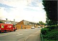
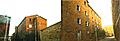
A former work shed in Banbury's Tramway Estate, opposite Morrison's supermarket in 2011. It is now used by Lazercraft, Wacky Wardrobe and Swan Foundry. It was built in about 1880 and was part of the former Britannia Works complex.
-
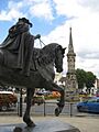
The 2006 'fine lady' and 1859 Banbury Cross.
-
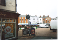
The building on extreme left foreground (the one where the sign is cut off to read " 'hop".) apparently has, on its Market Place-facing side, musket ball holes which date from the English Civil War. It was built in 1570. The muskets were fired from the castle, which stood on the other side of the Market Place, roughly where that row of buildings in the background stands.
-

Grimsbury in 1999 (right) and 2000 (left) prior to its redevelopment from 2004 to 2008. The Irish pub was reduced in size and renovated, a house was built on part of the old pub, the public toilet was removed in favour of a very small park and the garage became a Londis shop.
-

The "Shires" crossroads in 1999 to the left, prior to redevelopment in 2003, and the same place in 2009 to the right.
-
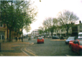
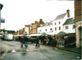
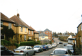
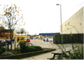
Bridge Street in 2001.
-
Neithrop Library.
-
Banbury Market
-
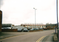
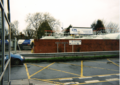
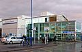
The station car park. The Whiz Kids' Nursery and activity centre is in the background.
-
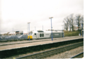
Banbury station. An EWS freight rain and a Wrexham, Marylebone train are here too.
-
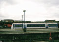
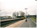
Banbury station. A Chiltern Railways Train arrives at Banbury railway station.
-
Banbury station. A former Wrexham & Shropshire locomotive stabled at Banbury station.
-
The 60-year-old oil terminal next to Banbury station. (It was upgraded circa 1980).
-

Browning park in Easington estate in 2001.
-
Part of the Neithrop estate, built in the 1920s or 1930s.
-
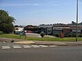
Local Shops. The small 1960s shopping precinct at the junction of Mewburn Road and the Queensway, Banbury.
-
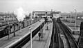
Banbury Station View SE, towards Oxford and London. This is the main (General) station, on the former GWR Paddington to Birmingham line, so decrepit and a bottleneck it was rebuilt very soon after Nationalisation. Date 24 March 1961(1961-03-24).
-
Banbury Market.
-
Castle Quay's 1969 car park. The one from 1978 is not shown.
-
The booking hall and main entrance Banbury railway station, managed by Chiltern Railways.
-
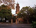
St Mary's Church, Banbury. It was built in the 1790s to replace the Medieval one damaged during the English Civil War.
-
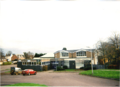
Banbury's former Crest Hotels building has been derelict for a long time.
-

Banbury war memorial in People's park on 29 November 2010.


.png)
.png)

.png)
.png)
.png)
.png)


.png)


.png)


