
Susanville, California facts for kids
Quick facts for kids
City of Susanville
|
|
|---|---|

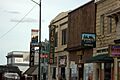
Historic Uptown Susanville
|
|
| Nickname(s):
The Hub of Northeastern California
|
|

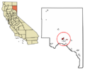
Location in Lassen County and the state of California
|
|

Susanville, California
Location in California

Susanville, California
Location in the United States
|
|
| Country | United States |
| State | California |
| County | Lassen |
| Incorporated | August 24, 1900 |
| Named for | Susan Roop |
| Area | |
| • Total | 8.03 sq mi (20.80 km2) |
| • Land | 7.94 sq mi (20.58 km2) |
| • Water | 0.09 sq mi (0.22 km2) 1.07% |
| Elevation | 4,186 ft (1,276 m) |
| Population
(2020)
|
|
| • Total | 16,728 |
| • Density | 2,106.80/sq mi (812.83/km2) |
| Demonym(s) | Susanvillain |
| Time zone | UTC-8 (Pacific (PST)) |
| • Summer (DST) | UTC-7 (PDT) |
| ZIP codes |
96127, 96130
|
| Area code(s) | 530 |
| FIPS code | 06-77364 |
| GNIS feature IDs | 277619, 2412017 |

Susanville is a city in Lassen County, California, United States. It is the main city of Lassen County. Susanville is located by the Susan River in the southern part of the county. It sits at an elevation of about 1,276 meters (4,186 feet) above sea level.
The city was once known as Rooptown. Its name in the Nümü (Northern Paiute) language is Pam Sewim K'odom, which means bush creek country. As of the 2020 census, Susanville had a population of 16,728 people. This number was a bit lower than the 17,947 people counted in 2010.
Susanville used to be a big center for logging and mining. Today, a large part of its economy comes from state and federal prisons located nearby. These prisons provide many jobs for the people living in Susanville.
Contents
The Story Behind Susanville's Name
The city was first called Rooptown. It was named after Isaac Roop, an early explorer and settler in the area. In 1857, Isaac Roop decided to change the town's name. He renamed it Susanville to honor his daughter, Susan Roop.
A Look at Susanville's Past
The first US post office in Susanville opened in 1860. In its early days, Susanville was an important stop for people traveling by wagon. It was where the Nobles Emigrant Trail from Nevada met the Humboldt Wagon Road, which led west to Chico. Susanville officially became a city in 1900.
For a long time, Susanville's main jobs were in farming, mining, and the lumber industry. However, as these industries changed, many jobs were lost. Since the late 1900s, the biggest growth in Susanville's economy has been due to the building and running of prisons.
Today, many adults in Susanville work at the prisons. These include the California Correctional Center, the High Desert State Prison, California, and the Federal Correctional Institution, Herlong. These prisons hold thousands of people.
Where is Susanville Located?
Susanville is found at the start of the Honey Lake Valley. It is about 64 kilometers (40 miles) east of Lassen Peak. The city is often seen as a gateway to Reno, which can be reached by U.S. Route 395.
The United States Census Bureau says that Susanville covers a total area of about 20.8 square kilometers (8.03 square miles). Most of this area, about 20.58 square kilometers (7.95 square miles), is land. A small part, about 0.22 square kilometers (0.09 square miles), is water.
What is the Ground Like in Susanville?
The ground under Susanville is made of igneous rock. This type of rock helps create the soil found in the area. The soil is usually brown, stony, and drains water well. It is often a mix of sand and gravel. In the western parts of the city, where there are forests, the soil can be reddish-brown.
What is Susanville's Weather Like?
Susanville has a warm-summer Mediterranean climate. This means it has cool winters and hot, mostly dry summers. Sometimes, there are thunderstorms in the afternoon during summer.
Temperatures in Susanville often reach 32°C (90°F) or higher about 30 days each year. They drop to 0°C (32°F) or lower about 148 days a year. It can even freeze in any month of the year, but very cold temperatures are rare. The hottest temperature ever recorded was 41°C (106°F) in July 1928 and 1931. The coldest was -31°C (-23°F) in February 1956.
Susanville gets about 33.07 centimeters (13.02 inches) of rain each year. It rains on average about 38 days a year. The most rain in one year was 85.12 centimeters (33.51 inches) in 1907. The most snow in one year was 289.56 centimeters (114 inches) in 1937.
| Climate data for Susanville, California, 1991–2020 normals, extremes 1895–present | |||||||||||||
|---|---|---|---|---|---|---|---|---|---|---|---|---|---|
| Month | Jan | Feb | Mar | Apr | May | Jun | Jul | Aug | Sep | Oct | Nov | Dec | Year |
| Record high °F (°C) | 68 (20) |
69 (21) |
81 (27) |
90 (32) |
96 (36) |
102 (39) |
106 (41) |
105 (41) |
101 (38) |
90 (32) |
83 (28) |
65 (18) |
106 (41) |
| Mean maximum °F (°C) | 54.4 (12.4) |
59.6 (15.3) |
69.4 (20.8) |
76.9 (24.9) |
85.1 (29.5) |
92.2 (33.4) |
96.8 (36.0) |
95.2 (35.1) |
90.4 (32.4) |
79.9 (26.6) |
67.7 (19.8) |
55.6 (13.1) |
97.8 (36.6) |
| Mean daily maximum °F (°C) | 42.7 (5.9) |
47.6 (8.7) |
54.2 (12.3) |
60.5 (15.8) |
69.3 (20.7) |
78.9 (26.1) |
88.0 (31.1) |
86.6 (30.3) |
80.0 (26.7) |
67.0 (19.4) |
51.9 (11.1) |
42.6 (5.9) |
64.1 (17.8) |
| Daily mean °F (°C) | 32.5 (0.3) |
36.6 (2.6) |
41.9 (5.5) |
47.1 (8.4) |
54.8 (12.7) |
62.9 (17.2) |
70.6 (21.4) |
69.3 (20.7) |
62.7 (17.1) |
51.5 (10.8) |
40.0 (4.4) |
32.4 (0.2) |
50.2 (10.1) |
| Mean daily minimum °F (°C) | 22.3 (−5.4) |
25.6 (−3.6) |
29.6 (−1.3) |
33.8 (1.0) |
40.2 (4.6) |
47.0 (8.3) |
53.1 (11.7) |
52.0 (11.1) |
45.3 (7.4) |
35.9 (2.2) |
28.1 (−2.2) |
22.3 (−5.4) |
36.3 (2.4) |
| Mean minimum °F (°C) | 9.0 (−12.8) |
11.5 (−11.4) |
16.8 (−8.4) |
22.4 (−5.3) |
28.7 (−1.8) |
34.3 (1.3) |
43.5 (6.4) |
42.4 (5.8) |
32.5 (0.3) |
23.6 (−4.7) |
14.5 (−9.7) |
8.1 (−13.3) |
4.4 (−15.3) |
| Record low °F (°C) | −22 (−30) |
−23 (−31) |
−4 (−20) |
10 (−12) |
20 (−7) |
25 (−4) |
30 (−1) |
31 (−1) |
18 (−8) |
12 (−11) |
−1 (−18) |
−22 (−30) |
−23 (−31) |
| Average precipitation inches (mm) | 2.44 (62) |
2.31 (59) |
1.67 (42) |
0.49 (12) |
0.82 (21) |
0.37 (9.4) |
0.21 (5.3) |
0.11 (2.8) |
0.24 (6.1) |
0.97 (25) |
1.49 (38) |
1.90 (48) |
13.02 (330.6) |
| Average snowfall inches (cm) | 4.1 (10) |
3.6 (9.1) |
0.7 (1.8) |
0.4 (1.0) |
0.0 (0.0) |
0.0 (0.0) |
0.0 (0.0) |
0.0 (0.0) |
0.0 (0.0) |
0.0 (0.0) |
0.6 (1.5) |
2.1 (5.3) |
11.5 (28.7) |
| Average precipitation days (≥ 0.01 in) | 5.8 | 4.9 | 4.6 | 3.9 | 3.4 | 2.0 | 0.9 | 0.5 | 1.0 | 2.1 | 3.9 | 5.7 | 38.7 |
| Average snowy days (≥ 0.1 in) | 1.5 | 1.5 | 0.4 | 0.2 | 0.0 | 0.0 | 0.0 | 0.0 | 0.0 | 0.0 | 0.5 | 1.2 | 5.3 |
| Source 1: NOAA | |||||||||||||
| Source 2: National Weather Service | |||||||||||||
How Many People Live in Susanville?
| Historical population | |||
|---|---|---|---|
| Census | Pop. | %± | |
| 1890 | 882 | — | |
| 1910 | 688 | — | |
| 1920 | 918 | 33.4% | |
| 1930 | 1,358 | 47.9% | |
| 1940 | 1,575 | 16.0% | |
| 1950 | 5,338 | 238.9% | |
| 1960 | 5,598 | 4.9% | |
| 1970 | 6,608 | 18.0% | |
| 1980 | 6,520 | −1.3% | |
| 1990 | 7,279 | 11.6% | |
| 2000 | 13,541 | 86.0% | |
| 2010 | 17,947 | 32.5% | |
| 2020 | 16,728 | −6.8% | |
| 2023 (est.) | 12,689 | −29.3% | |
| U.S. Decennial Census | |||
The population of Susanville has changed a lot over the years. In 1890, there were 882 people. By 2020, the population had grown to 16,728.
Susanville's Population in 2010
In 2010, Susanville had 17,947 people. About 52.6% of these people lived in homes. The rest, about 46.8%, were in institutions like prisons.
Most of the people were White (62.8%). There were also African American (12.5%), Native American (1.2%), Asian (1.1%), and Pacific Islander (0.6%) residents. About 23.7% of the people were of Hispanic or Latino background.
There were 3,833 households in Susanville. About 35.4% of these households had children under 18. The average household had 2.46 people. The average family had 3.05 people.
The median age in Susanville was 33.6 years. This means half the people were younger than 33.6, and half were older.
Getting Around Susanville

Susanville is located where two important roads meet: California State Route 36 and 139. Route 139 goes north to Oregon, leading to Klamath Falls. Route 36 goes west to Red Bluff and east to U.S. Route 395. U.S. 395 connects Alturas to the north and Reno to the south.
The Susanville Municipal Airport is about 8 kilometers (5 miles) southeast of the city. It is a public airport used for general aviation. For getting around the city, the Lassen Rural Bus provides bus service. The Sage Stage bus connects Susanville to other towns like Alturas and Reno.
A train line that used to serve Susanville stopped running in 2004. You can still see a Union Pacific Railroad caboose next to the old train depot.
Susanville's Economy and Jobs
Susanville's economy is strongly linked to the prisons in the area. The High Desert State Prison is located in Susanville.
Who are the Biggest Employers?
Here are the top employers in Susanville, based on a 2014 report:
| # | Employer | # of Employees |
|---|---|---|
| 1 | High Desert State Prison | 1,250 |
| 2 | Lassen County | 441 |
| 3 | Susanville Indian Rancheria | 295 |
| 4 | Lassen College | 267 |
| 5 | Banner Lassen Medical Center | 197 |
| 6 | Diamond Mountain Casino | 179 |
| 7 | Walmart | 150 |
| 8 | Susanville School District | 101 |
| 9 | Lassen Nursing & Rehabilitation Center | 101 |
| 10 | Lassen Union High School District | 85 |
| 11 | Northeastern Rural Health | 81 |
| 12 | Safeway | 80 |
| 13 | City of Susanville | 62 |
| 14 | Susanville Supermarket IGA | 48 |
Famous People from Susanville
Many notable people have connections to Susanville:
- Dugan Aguilar (1947–2018), a photographer with Maidu, Achomawi, and Northern Paiute heritage.
- Frank Cady, an actor known for TV shows like Petticoat Junction and Green Acres.
- Aaron Duran, a writer and media producer who grew up in the city.
- Jack Ellena, a former Los Angeles Rams football player, was born and raised here.
- Mike Leach, a well-known college football coach, was born in Susanville.
- Mitch Lively, a former baseball player for the San Francisco Giants, was born in the city.
- Ryan O'Callaghan, an NFL player for the Kansas City Chiefs and New England Patriots.
- Frank Shamrock and Ken Shamrock, famous mixed martial artists.
- Mike Skinner, a NASCAR race car driver.
- Benjamin "Coach" Wade, a reality television contestant.
Images for kids
-
Historic Uptown Susanville
-
Location in Lassen County and the state of California
-
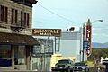
Another view of Uptown Susanville
-
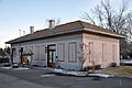
Susanville Railroad Depot, a historic building from 2013
See also
 In Spanish: Susanville (California) para niños
