
Hutt River (New Zealand) facts for kids
Quick facts for kids Te Awa Kairangi / Hutt River |
|
|---|---|

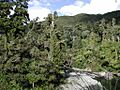
The Hutt River looking downstream
|
|
| Other name(s) | Te Wai o Orutu |
| Country | New Zealand |
| Physical characteristics | |
| Main source | Tararua Ranges |
| River mouth | Wellington Harbour 0 m (0 ft) |
| Length | 56 km (35 mi) |
| Basin features | |
| Basin size | 655 km2 (253 sq mi) |
The Hutt River is a river in the southern North Island of New Zealand. Its official name is Te Awa Kairangi / Hutt River. It flows for about 56 kilometres (35 mi) from the Tararua Range towards the south-west. Along its path, it creates flat, fertile areas called floodplains, like those in Kaitoke, Upper Hutt, and Lower Hutt.
The Hutt River Trail is a popular path that follows the river. It's part of a regional park managed by the Wellington Regional Council.
Contents
What's in a Name? The Hutt River's History
Early Māori people, like the Ngāi Tara tribe, called the river Te Awa Kairangi. Later, other Māori settlers named it Te Wai o Orutu. This was in honor of Orutu, an ancestor from the Ngāti Mamoe tribe. By the time European settlers arrived, Māori often called it Heretaunga. This name is still used today for a suburb and a secondary school in Upper Hutt.
The river got the name Hutt from Sir William Hutt. He was the chairman of the New Zealand Company, which helped settle New Zealand. Captain Edward Main Chaffers and Colonel William Wakefield gave it this name in 1839. They were busy mapping Port Nicholson at the time. Since 2011, the river's official name has been Te Awa Kairangi / Hutt River.
Journey of the River: Hutt River's Geography

For most of its journey, the Hutt River is quite shallow. It often spreads out into many small channels, which is called a braided river. Its bed is wide and rocky. However, in the Kaitoke gorge, the river flows over solid rock. As it gets closer to its mouth at Petone, the river becomes narrower and its banks are steeper.
To protect the larger towns of Upper Hutt and Lower Hutt from floods, special walls called stopbanks have been built. Willow trees have also been planted along the banks. This is a common way to manage rivers in New Zealand.
Where the River Begins: Headwaters and Kaitoke Gorge
The very start of the river, called the headwaters, is in the Kaitoke Regional Park. This area is closed to visitors. This is to keep the drinking water clean, as water is taken from Kaitoke to supply the wider Wellington area. Below Kaitoke is the Kaitoke Gorge. This part of the river is a popular spot for rafting. Further down, at Te Mārua, the Mangaroa River joins the Hutt from the east.
River's Path Through Upper Hutt
At Birchville, the Akatarawa River flows into the Hutt from the west. Here, the river runs in a deep channel between hills. It then turns to flow across the Wellington Fault. This is a major crack in the Earth's crust. You can see how the fault has moved the land by looking at the river terraces in Harcourt Park.
At the start of the Upper Hutt floodplain, the river makes a sharp turn against a cliff at Maoribank. It then flows down the valley. Most of Upper Hutt city is located on this floodplain. The Whakatiki River joins the Hutt from the west. Around this point, the river begins to follow the straight line of the Wellington geologic fault. This fault runs along the western side of the river valley.
From Upper Hutt to the Sea
At the lower end of the Upper Hutt floodplain is the Taita Gorge. This gorge separates Upper Hutt from Lower Hutt. It's much shorter and less narrow than the Kaitoke Gorge. The river finally flows into Wellington Harbour at Petone. The geological fault that the river followed continues as a steep cliff along the edge of the harbor.
State Highway 2 generally follows the river's path for most of its length. It doesn't follow it through the Kaitoke Gorge or at the very start of the river. After the river, the highway crosses the Remutaka Range into the Wairarapa region.
Hutt River Through Time: A Brief History
The Hutt River has changed its course quite a bit since European settlers arrived. This was mainly due to a big earthquake in 1855. The earthquake actually raised the riverbed.
Lower Hutt used to flood regularly, which made the land very fertile. Before the first Labour Government started building state housing in 1937, there were many market gardens in Lower Hutt. These gardens grew fresh produce for people.
Well-known walking paths along the river were officially marked with signs in the 1990s. This was a team effort involving the Wellington Regional Council, local Rotary International clubs, Hutt City Council, Upper Hutt City Council, and other groups.
Fun on the River: Recreation and Activities
The Hutt River Trail is a 29-kilometre (18 mi) path for cycling and walking. It follows the entire length of the river from Petone to Kaitoke Regional Park in Upper Hutt. Most of the path is gravel, but some parts are sealed (like a road) or grass. Be aware that some low-lying parts of the trail can get flooded.
There are several great spots along the river for swimming, fishing, and kayaking. If you're a fan of movies, you might recognize some parts of the trail. Some scenes from the famous Lord of the Rings film series were filmed here!
The Lower Hutt Parkrun is a weekly event that takes place along the last 2.5-kilometre (1.6 mi) section of the Hutt River. It runs from just north of the Ewen Bridge down to the Waione Bridge and back.
River Life: Ecology
The river is home to a good number of brown trout. These fish are popular with anglers.
Crossing the River: Bridges of the Hutt
Many bridges cross the Hutt River, connecting different communities. Here are some of them, listed as you would travel downstream:
- Kaitoke Swingbridges: These are two footbridges found in Kaitoke Regional Park.
- Akatarawa Road Bridge: This is a two-lane road bridge that opened in 1981. It replaced an older, single-lane bridge.
- Norbert Street Footbridge: This bridge connects California Park in Totara Park with Harcourt Park in Birchville.
- Totara Park Bridge (Totara Park Road): A two-lane road bridge that opened around 1970. It provides access to the suburb of Totara Park.
- Moonshine Bridge (River Road/SH 2): This is a curved, two-lane road bridge that opened in 1987. It was built as part of a bypass road for Upper Hutt.
- Silverstream Road Bridge (Fergusson Drive): This two-lane road bridge also carries a large water supply pipe underneath it. This pipe connects the Te Mārua water treatment plant to Porirua and Wellington City.
- Silverstream Rail Bridge (Wairarapa Line): A double-track rail bridge that opened in 1954.
- Pomare Rail Bridge (Wairarapa Line): Another double-track rail bridge, opened in 1954 as part of the Hutt Valley railway changes.
- Kennedy-Good Bridge (Fairway Drive): This two-lane road bridge opened in 1979. It was the first bridge at this location and is named after the Mayor of Lower Hutt at the time.
- Melling Bridge (Melling Link Road): A three-lane bridge that opened in 1957. It has one lane for eastbound traffic and two for westbound.
- New Ewen Bridge: This is a single-span arch bridge with four traffic lanes and footpaths. It opened in 1996 and is the seventh bridge to be built at this site!
- The Rail Bridge (Wairarapa Line): A two-track rail bridge with a walkway for pedestrians. It opened in 1927.
- Estuary Bridge (Waione Street): A two-lane road bridge opened in 1954. It carries another large water supply pipe, connecting water treatment plants to Wellington City.
Images for kids
-
Hutt River from flume bridge, Kaitoke
See also
 In Spanish: Río Hutt para niños
