
Image: TorresStraitIslandsMap
Size of this preview: 604 × 599 pixels. Other resolutions: 242 × 240 pixels | 929 × 922 pixels.
Original image (929 × 922 pixels, file size: 28 KB, MIME type: image/png)
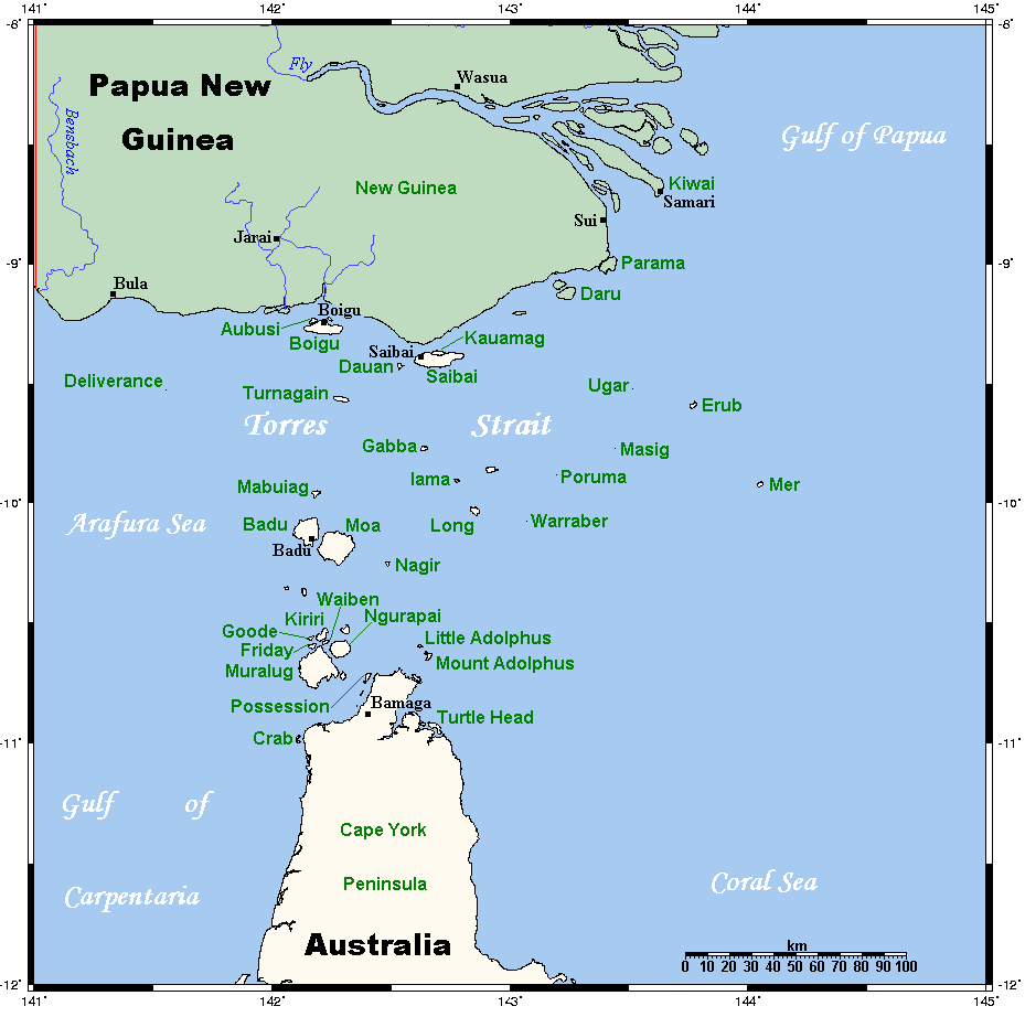
Description: A map of the Torres Strait Islands. I have endeavoured to use native names wherever I could find them. If you can suggest ways in which this map could be made more up to date, don't hesitate to leave me a message to that effect. This map's source is here, with the uploader's modifications, and the GMT homepage says that the tools are released under the GNU General Public License.
Title: TorresStraitIslandsMap
Credit: Transferred from en.wikipedia to Commons.
Author: Kelisi at English Wikipedia
Usage Terms: Creative Commons Attribution-Share Alike 3.0
License: CC-BY-SA-3.0
License Link: http://creativecommons.org/licenses/by-sa/3.0/
Attribution Required?: Yes
Image usage
The following 33 pages link to this image:
- Adolphus Channel
- Boigu Island (Queensland)
- Bourke Isles
- Coconut Island (Queensland)
- Crab Island (Queensland)
- Darnley Island (Queensland)
- Endeavour Strait
- Gebar Island
- Halfway Island (Queensland)
- Horn Island, Queensland
- Indigenous Australians
- Kaurareg
- List of Torres Strait Islands
- List of birds of the Torres Strait Islands
- List of butterflies of Australia
- Masig Island, Queensland
- Meriam people
- Moa Island (Queensland)
- Mount Adolphus Island
- Murray Island, Queensland
- Prince of Wales Island (Queensland)
- Saibai Island
- Stephen Island (Torres Strait)
- Thursday Island
- Torres Strait
- Torres Strait Islanders
- Torres Strait Islands
- Trochus Island
- Turnagain Island (Queensland)
- Turtle Head Island
- Turtle Island (Newcastle Bay)
- Warul Kawa Indigenous Protected Area
- Yam Island

All content from Kiddle encyclopedia articles (including the article images and facts) can be freely used under Attribution-ShareAlike license, unless stated otherwise.