Independence, California facts for kids
Quick facts for kids
Independence
|
|
|---|---|
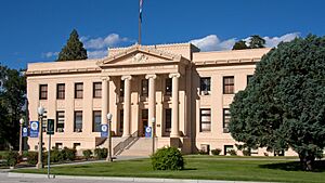
Inyo County Courthouse
|
|
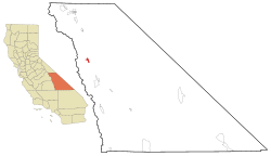
Location in Inyo County and the state of California
|
|
| Country | |
| State | |
| County | Inyo |
| Area | |
| • Total | 4.870 sq mi (12.612 km2) |
| • Land | 4.867 sq mi (12.605 km2) |
| • Water | 0.003 sq mi (0.007 km2) 0.057% |
| Elevation | 3,904 ft (1,190 m) |
| Population
(2020)
|
|
| • Total | 593 |
| • Density | 121.77/sq mi (47.02/km2) |
| Time zone | UTC-8 (Pacific (PST)) |
| • Summer (DST) | UTC-7 (PDT) |
| ZIP Code |
93526
|
| Area codes | 442/760 |
| FIPS code | 06-36350 |
| GNIS feature ID | 2408418 |
Independence is a small town in Inyo County, California. It's not officially a city, but it's a special kind of community called a census-designated place. Independence is about 41 miles (66 km) south of Bishop. It sits at an elevation of 3,930 feet (1,198 meters) above sea level.
This town is important because it's the county seat of Inyo County. This means it's where the main government offices for the county are located. In 2010, about 669 people lived here.
Contents
Geography of Independence
Independence is located in the beautiful Owens Valley in California. The main highway, U.S. Route 395, runs right through the middle of the town.
Mountains and Wilderness Areas
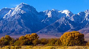
To the west of Independence, you'll find the towering Sierra Nevada mountains. These mountains are part of the John Muir Wilderness Area, a protected natural space.
A popular spot for hikers is Onion Valley, which is west of Independence. From here, trails lead into Kings Canyon and Sequoia National Parks. These parks protect the western side of the Sierra Nevada.
Pacific Crest Trail Stop
Independence is a helpful stop for people hiking the Pacific Crest Trail. This famous trail is 2,650 miles (4,265 km) long and goes all the way from Mexico to Canada. It follows the highest parts of the Sierra Nevada and Cascade mountain ranges.
The highest point on the entire Pacific Crest Trail is Forester Pass, which is 13,153 feet (4,009 meters) high. It's located directly west of Independence. Hikers often stop in Independence to get supplies before or after tackling this challenging part of the trail.
The town of Independence covers about 4.9 square miles (12.7 square kilometers) of land.
Climate in Independence
Independence and the Owens Valley have a cool arid climate. This means it's a dry place with hot summers and cool winters.
Temperature and Weather
- In January, the average high temperature is about 54°F (12°C), and the average low is 27.4°F (-2.6°C).
- In July, the average high is about 97.6°F (36.4°C), and the average low is 63.9°F (17.7°C).
- The hottest temperature ever recorded was 115°F (46°C) in June 2017.
- The coldest temperature ever recorded was -5°F (-21°C) on January 9, 1937.
- On average, there are about 97 days each year where the temperature reaches 90°F (32°C) or higher.
- There are also about 88 mornings each year where the temperature drops to 32°F (0°C) or below.
Rainfall and Snow
Independence doesn't get much rain, averaging only about 5.82 inches (14.8 cm) per year. The most rain in one month was 10.71 inches (27.2 cm) in January 1969. Snowfall changes a lot each year, but it averages only about 5.5 inches (14 cm).
| Climate data for Independence, CA | |||||||||||||
|---|---|---|---|---|---|---|---|---|---|---|---|---|---|
| Month | Jan | Feb | Mar | Apr | May | Jun | Jul | Aug | Sep | Oct | Nov | Dec | Year |
| Record high °F (°C) | 80 (27) |
86 (30) |
99 (37) |
102 (39) |
105 (41) |
115 (46) |
114 (46) |
110 (43) |
108 (42) |
99 (37) |
93 (34) |
77 (25) |
115 (46) |
| Mean daily maximum °F (°C) | 54.3 (12.4) |
58.2 (14.6) |
65.6 (18.7) |
73.0 (22.8) |
82.0 (27.8) |
91.4 (33.0) |
97.9 (36.6) |
96.0 (35.6) |
88.7 (31.5) |
76.9 (24.9) |
64.0 (17.8) |
54.3 (12.4) |
75.2 (24.0) |
| Mean daily minimum °F (°C) | 27.5 (−2.5) |
31.3 (−0.4) |
36.4 (2.4) |
42.5 (5.8) |
50.8 (10.4) |
58.7 (14.8) |
64.1 (17.8) |
62.0 (16.7) |
55.1 (12.8) |
45.0 (7.2) |
34.2 (1.2) |
28.1 (−2.2) |
44.6 (7.0) |
| Record low °F (°C) | −5 (−21) |
2 (−17) |
14 (−10) |
21 (−6) |
27 (−3) |
32 (0) |
43 (6) |
43 (6) |
33 (1) |
22 (−6) |
11 (−12) |
−2 (−19) |
−5 (−21) |
| Average precipitation inches (mm) | 1.01 (26) |
1.01 (26) |
0.44 (11) |
0.24 (6.1) |
0.16 (4.1) |
0.11 (2.8) |
0.13 (3.3) |
0.13 (3.3) |
0.18 (4.6) |
0.26 (6.6) |
0.56 (14) |
1.00 (25) |
5.23 (132.8) |
| Average snowfall inches (cm) | 1.4 (3.6) |
0.5 (1.3) |
0.1 (0.25) |
0 (0) |
0 (0) |
0 (0) |
0 (0) |
0 (0) |
0 (0) |
0 (0) |
0 (0) |
1.1 (2.8) |
3.1 (7.95) |
| Source: http://www.wrcc.dri.edu/cgi-bin/cliMAIN.pl?ca4232 | |||||||||||||
History of Independence
Independence started as a trading post in 1861, founded by Charles Putnam. A trading post was a place where people could buy and sell goods. It was first called "Putnam's," then "Little Pine." The spot where Putnam's Cabin stood is now a California Historical Landmark.
Fort Independence and County Seat
The town of Independence grew from a US Army camp called Camp Independence. This camp was set up on July 4, 1862, by Lieutenant Colonel George S. Evans. He created the camp because local settlers were worried about conflicts with the Native American tribes in the area.
The camp closed for a short time but reopened as Fort Independence in 1865 when conflicts started again. The fort was finally closed in 1877. Today, the area is a reservation for the Fort Independence Indian Community of Paiute Indians.
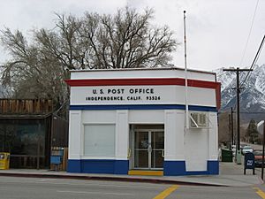
Independence became the main town, or "county seat," of Inyo County in 1866. It won this title after another mining town, Kearsarge, was destroyed by an avalanche. The first post office in Independence opened in 1866.
A famous person born in Independence was United States Army General John K. Singlaub (1921 – 2022).
Local Attractions
Independence has some interesting places to visit:
- The Eastern California Museum is located at 155 North Grant Street. It has many collections, exhibits, and programs that teach about the history and culture of the area.
- The home of author Mary Hunter Austin is also a museum. Mary Austin wrote a famous book called The Land of Little Rain. Her home is at 235 Market Street in Independence.
Community Library
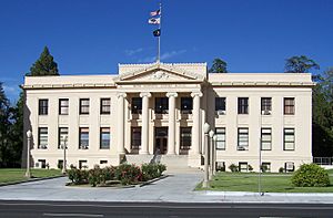
The Inyo County Free Library is located inside the Inyo County Courthouse.
Population of Independence
According to the 2010 United States Census, Independence had a population of 669 people. Most of the people (73.7%) were White. There were also Native Americans (14.6%), African Americans (0.9%), Asians (1.2%), and Pacific Islanders (0.1%). About 13.9% of the population identified as Hispanic or Latino.
Most people (90.1%) lived in homes, while a small number lived in group housing or institutions.
There were 301 households in Independence.
- About 18.9% of households had children under 18.
- Many households (43.5%) were married couples.
- About 40.5% of households were single individuals.
- The average household had 2 people.
The population was spread out by age:
- 14.9% were under 18 years old.
- 8.1% were aged 18 to 24.
- 17.5% were aged 25 to 44.
- 38.7% were aged 45 to 64.
- 20.8% were 65 years or older.
The average age in Independence was 51.1 years.
Most homes (69.8%) were owned by the people living in them, and 30.2% were rented.
Independence in Media
Independence was a filming location for the 1990 movie Tremors. The film set for the characters Burt and Heather's house was built and filmed in the hills above Independence.
See also
 In Spanish: Independence (condado de Inyio) para niños
 | Sharif Bey |
 | Hale Woodruff |
 | Richmond Barthé |
 | Purvis Young |


