
Independence Monument (Colorado) facts for kids
Quick facts for kids Independence Monument |
|
|---|---|
| Independence Rock | |

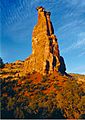
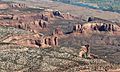
South aspect
|
|
| Highest point | |
| Elevation | 5,739 ft (1,749 m) |
| Prominence | 379 ft (116 m) |
| Isolation | 0.26 mi (0.42 km) |
| Parent peak | The Island (5,770 ft) |
| Geography | |

Independence Monument
Location in Colorado

Independence Monument
Location in the United States
|
|
| Location | Colorado National Monument Mesa County, Colorado, U.S. |
| Parent range | Colorado Plateau Uncompahgre Plateau |
| Topo map | USGS Colorado National Monument |
| Geology | |
| Age of rock | Late Triassic to Early Jurassic |
| Type of rock | Wingate Sandstone |
| Climbing | |
| First ascent | June 14, 1911 John Otto |
| Easiest route | class 5.9- climbing |
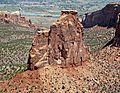
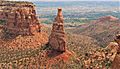
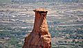
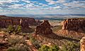
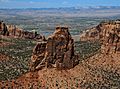
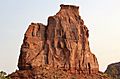
Independence Monument is a huge sandstone pillar in Colorado National Monument. It stands 5,739 feet (about 1,749 meters) tall. You can find it in Mesa County, in western Colorado, United States. This amazing landmark is about 450 feet high.
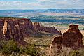
It is located near the monument's visitor center. It is also about 9 miles west of Grand Junction. Independence Monument rises high above Monument Canyon and Wedding Canyon. Many people enjoy climbing here. You can also see it clearly from Rim Rock Drive.
Contents
Who First Climbed Independence Monument?
John Otto came to the Grand Junction area in 1906. He lived alone in the canyons. He worked hard to create trails using only a pick and shovel. People remember Otto as the founder of Colorado National Monument. He was also its first park ranger.
Otto loved his country very much. He named many rock features after famous heroes and important events. Independence Monument still has the name he gave it.

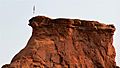
John Otto was the first person to climb Independence Monument. He reached the top on June 14, 1911. He flew the American flag from the summit for Flag Day. President William Howard Taft gave this flag to Otto.
After that, Otto would climb the monument every July 4th. He did this to display the flag and celebrate Independence Day. His climbing method was different from today's. He drilled holes and put in pieces of pipe to make a ladder. The park service removed these pipes in the 1950s. However, the handholds and steps he carved into the rock are still there.
John Otto married Beatrice Farnham, an artist from Boston. Their wedding took place on June 20, 1911. It was held at the base of Independence Monument in Wedding Canyon. Today, climbers continue a tradition. They raise the flag on the summit every July 4th.
Rock Climbing Routes
Independence Monument is a popular place for rock climbing. Climbers follow specific paths called routes. Here are some of the well-known climbing routes on Independence Monument:
- Otto's Route – This route is rated class 5.8+. It has 5 sections, called pitches. It was first climbed in 1911.
- Independence Chimney – This route is rated class 5.8. It has 6 pitches. It was first climbed in 1970.
- South Face Direct – This route is rated class 5.9. It has 5 pitches. It was first climbed in 1971.
- Sundial Dihedral – This route is rated class 5.11b. It has 6 pitches. It was first climbed in 1986.
- Dependence – This route is rated class 5.10+. It has 5 pitches. It was first climbed in 1994.
- Geezer Highway – This route is rated class 5.9+. It has 6 pitches.
How Was Independence Monument Formed?
This tall rock formation is what's left of a large rock wall. It is mostly made of Wingate Sandstone. This sandstone formed from ancient sand dunes about 200 million years ago. These dunes were created by wind during the Late Triassic period.
The very top of the monument has a thin layer of rock called a caprock. This caprock is made of stronger sandstone. It was formed by rivers. The ground around the base of Independence Monument is made of Chinle Formation rock. The canyon floor below is even older. It is made of Precambrian basement rock like gneiss, schist, and granite. Rainwater that falls on Independence Monument flows into the Colorado River. The river is about two miles away.
What is the Climate Like?
Independence Monument is in a semi-arid climate zone. This means it gets very little rain. Summers here are hot and dry. Winters are cold and can have some snow.
Temperatures can reach 100°F (38°C) about 5 days a year. They reach 90°F (32°C) about 57 days a year. Temperatures stay at or below freezing about 13 days a year. The best time to visit is from April through October. The weather is usually very pleasant then.
Gallery
-
-
-
Climbers nearing the summit, Note the steps John Otto carved into the rock.
-
-
-
-
-
-
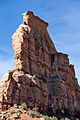
Independence Monument (left), Kissing Couple (right)
-
Pipe Organ (left), Independence Monument (right) from Rim Rock Drive
-
Climbers at the top of the first pitch of Otto's Route
-
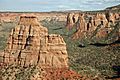
Left to rightː Egypt Rock, Kissing Couple, Grand View Spire, Independence Monument (centered), Pipe Organ (right).
_1_(23968808032).jpg)

_4_(23968823082).jpg)
.jpg)


.jpg)
.jpg)
Images for kids
-
Aerial view with Independence Monument centered

