
Kissing Couple facts for kids
Quick facts for kids Kissing Couple |
|
|---|---|

Southeast aspect
|
|
| Highest point | |
| Elevation | 5,815 ft (1,772 m) |
| Prominence | 305 ft (93 m) |
| Isolation | 2.28 mi (3.67 km) |
| Parent peak | Black Ridge |
| Geography | |

Kissing Couple
Location in Colorado

Kissing Couple
Location in the United States
|
|
| Location | Colorado National Monument Mesa County, Colorado, U.S. |
| Parent range | Colorado Plateau Uncompahgre Plateau |
| Topo map | USGS Colorado National Monument |
| Geology | |
| Age of rock | Late Triassic to Early Jurassic |
| Type of rock | Wingate Sandstone |
| Climbing | |
| First ascent | 1960 |
| Easiest route | class 5.11a climbing |
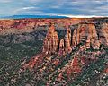
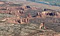
Kissing Couple is a tall, impressive rock pillar found in Colorado National Monument. It stands 5,815 feet (about 1,772 meters) high. This amazing sandstone tower is located in Mesa County, in western Colorado, United States.
This 400-foot-high tower is on the west side of Monument Canyon. It's about 1.5 miles southeast of the monument's visitor center. It's also 9 miles west of Grand Junction. You can see it from viewpoints along Rim Rock Drive.
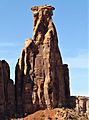
The name "Kissing Couple" was chosen because the rock looks like two people hugging. The name was officially recognized in 1982. Some climbers also call it "Bell Tower."
Contents
Exploring Kissing Couple
The first time anyone climbed to the top of Kissing Couple was on May 4, 1960. The climbers were Layton Kor, Harvey Carter, and John Auld. They used a route called Long Dong Wall. In 1977, Andy Petefish, Tom Stubbs, and Jim Pearson were the first to climb it without using ropes for support (this is called free ascent).
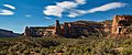
Kissing Couple is also near another popular climbing spot, Independence Monument. Both can be seen from the scenic Rim Rock Drive.
How Kissing Couple Formed
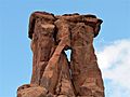
This rock tower is what's left of a larger rock formation. It was shaped over time by wind and water. It's mostly made of a type of rock called Wingate Sandstone. This sandstone formed from ancient sand dunes about 200 million years ago. These dunes were blown by the wind during the Late Triassic period.
The very top of the tower has a thin layer of harder rock. This rock is from the Kayenta Formation. The slopes around the base of Kissing Couple are made of Chinle Formation rock. The very bottom of the canyon has much older rocks. These are called Precambrian basement rock. They include gneiss, schist, and granite.
The tower even has a small natural arch. This arch formed when a crack in the rock got bigger over time. Any rain that falls on Kissing Couple eventually flows into the Colorado River. The river is about three miles to the northeast.
Weather in the Area
Kissing Couple is in a semi-arid climate zone. This means it gets hot, dry summers. Winters are cold, and there can be some snow.
Temperatures can reach 100°F (38°C) on a few days each year. They often reach 90°F (32°C) for many days. Temperatures stay at or below freezing for about 13 days a year. The best time to visit is from April through October. The weather is usually very nice then.
Gallery
-
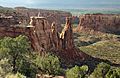
Southeast aspect from Rim Rock Drive
-
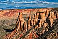
West aspect from Rim Rock Drive
-
-
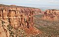
Independence Monument (left) and Kissing Couple (right)
-
-
Climbers on Kissing Couple
-
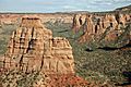
Egypt Rock (left), Kissing Couple (center), Grand View Spire (right) seen from Monument Canyon Trail


Images for kids
-
Kissing Couple detail
-
Aerial view with Kissing Couple lower right


