
Jabberwocky Tower facts for kids
Quick facts for kids Jabberwocky Tower |
|
|---|---|

Jabberwocky Tower
|
|
| Highest point | |
| Elevation | 6,840 ft (2,080 m) |
| Prominence | 40 ft (12 m) |
| Parent peak | Colchuck Balanced Rock 8200+ ft |
| Geography | |

Jabberwocky Tower
Location in Washington (state)

Jabberwocky Tower
Location in the United States
|
|
| Location | Washington state, U.S. |
| Parent range | Cascade Range |
| Topo map | USGS Enchantment Lakes |
| Type of rock | Granite |
| Climbing | |
| First ascent | July 13, 1970 by Dave Beckstead and Paul Myhre |
| Easiest route | Climbing class 5.6 |
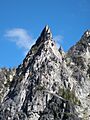
Jabberwocky Tower is a tall, pointy rock called a spire. It's made of granite and stands 6,840 feet high. You can find it in Chelan County in Washington state.
Jabberwocky Tower is part of The Enchantments, a beautiful area inside the Alpine Lakes Wilderness. It belongs to the Stuart Range, which is a smaller part of the huge Cascade Range. The tower sits east of Colchuck Lake and west of Enchantment Peak. Rain and melting snow from the tower flow into Icicle Creek, which then joins the Wenatchee River.
Weather in the Mountains
Most of our weather comes from the Pacific Ocean. These weather systems travel east toward the Cascade Mountains. When air from the ocean hits the tall Cascade Mountains, it has to rise. As it rises, it cools down and drops its moisture as rain or snow. This process is called Orographic lift.
Because of this, the Cascade Mountains get a lot of rain. They get especially a lot of snowfall in winter. During winter, the weather is usually cloudy. But in summer, high-pressure systems over the Pacific Ocean often bring clear skies. The snow here tends to be wet and heavy. This means there's a high risk of avalanches.
How the Mountains Formed
The Alpine Lakes Wilderness has very rugged land. It features jagged peaks, deep valleys carved by glaciers, and granite spires. There are also over 700 mountain lakes. Huge geological events happened millions of years ago. These events created the varied landscape and big changes in elevation. This also led to different climates across the Cascade Range.

The Cascade Mountains started forming millions of years ago. This was during the late Eocene Epoch. The North American Plate was moving over the Pacific Plate. This caused many periods of volcanic activity. Also, small pieces of the Earth's crust, called terranes, helped create the North Cascades. This happened about 50 million years ago.
During the Pleistocene period, which was over two million years ago, glaciers moved back and forth many times. They scraped the land and left behind piles of rock. The last glaciers in the Alpine Lakes area started to melt away about 14,000 years ago. By 10,000 years ago, they were north of the Canada–US border. The river valleys in this area have a "U" shape. This shape is a result of that recent glaciation.
Uplift (when land rises) and faulting (when cracks form in the Earth's crust) worked with glaciation. These processes have been the main forces. They created the tall peaks and deep valleys you see in the Alpine Lakes Wilderness today.

Images for kids
-
Jabberwocky Tower
-
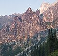
Jabberwocky Tower at sunset
-
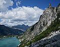
Colchuck Lake with Jabberwocky Tower in the background
