Jakin, Georgia facts for kids
Quick facts for kids
Jakin, Georgia
|
|
|---|---|

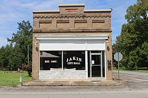
Jakin City Hall
|
|

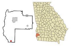
Location in Early County and the state of Georgia
|
|
| Country | United States |
| State | Georgia |
| County | Early |
| Government | |
| • Type | Mayor-council government |
| Area | |
| • Total | 1.24 sq mi (3.21 km2) |
| • Land | 1.24 sq mi (3.21 km2) |
| • Water | 0.00 sq mi (0.00 km2) |
| Elevation | 144 ft (44 m) |
| Population
(2020)
|
|
| • Total | 131 |
| • Density | 105.65/sq mi (40.78/km2) |
| Time zone | UTC-5 (Eastern (EST)) |
| • Summer (DST) | UTC-4 (EDT) |
| ZIP codes |
31761, 39861
|
| Area code(s) | 229 |
| FIPS code | 13-41792 |
| GNIS feature ID | 0316032 |
Jakin is a small city located in Early County, Georgia, United States. It became an official city in 1895. In 2020, about 131 people lived there.
Contents
History of Jakin
How Early County Started
Early County was created by a special law on December 15, 1818. The land was divided into lots of about 250 acres (1 square kilometer). These lots were given out by the state through lotteries in 1819 and 1820. Jakin is located in the very southern part of this county.
Early Settlers and Transportation
Around 1817, people started moving into the area. They built homes along old Native American paths near the river. These paths became a road called the Old River Road by 1820. By the mid-1820s, it was used for mail delivery. Sometimes, mail carriers faced trouble from Native Americans.
As the forests near the river were cleared, large farms called plantations appeared. The Chattahoochee River, about 3 miles (5 kilometers) to the west, was very important for travel and trade. Huge cut timbers were sent downstream to Apalachicola, Florida, for building ships. Turpentine, a liquid from pine trees, was also exported. Cotton was sent upstream to mills in Columbus. In 1821, the first machine to separate cotton fibers, called a cotton gin, was built nearby.
Founding Families and Name
Some of the first families to settle here were the Allens, Rambos, Donalsons, and Harrells. In 1828, a new road was built from Blakely to Bainbridge. More families, like the Hodges and Warrens, settled along this road. These families helped start what would become Jakin.
In May 1878, a doctor named C.A. Minter bought about 750 acres (3 square kilometers) of land. The first mayor of Jakin, James Morris "Major" Bivings, named the town "Jakin." He named it after one of the columns in Solomon's temple, a famous building from the Bible.
Growth and Industries
Besides small farms, Jakin grew because of the turpentine business. The area had many longleaf pine forests. These trees were first used for turpentine, then for lumber. Mayor Bivings and his partner, James W. Duke, started the Duke and Bivings Lumber Company. This company built houses, a store, and even had its own post office. Bivings was the first postmaster.
In 1898, the Flowers Company bought the lumber mill for $20,000. This included machines, buildings, materials, 160 acres (0.6 square kilometers) of land, and a railway. It's believed that about 1,000 workers were employed at the mill. By 1903, Jakin's population reached 2,000 people. However, World War I and too much tree cutting led to the mill closing in 1918.
Farming remained Jakin's main industry until 1963. That year, Great Northern Nekoosa bought a family-owned lumber mill. This company later became Great Southern Paper. They also ran a plywood mill in nearby Cedar Springs. In 1990, Great Southern Paper was bought by Georgia-Pacific. Then, in 2005, Georgia-Pacific was bought by Koch Industries. Even with these changes, the mill has kept running.
Geography
Jakin is located in the southern part of Early County. Its exact location is 31°5′26″N 84°58′59″W / 31.09056°N 84.98306°W.
U.S. Route 84 runs through the southern part of Jakin. This road goes southeast about 7 miles (11 kilometers) to Donalsonville. It goes northwest about 26 miles (42 kilometers) to Dothan, Alabama. Blakely, which is the main town of Early County, is about 21 miles (34 kilometers) north of Jakin.
According to the United States Census Bureau, Jakin covers a total area of about 1.24 square miles (3.2 square kilometers). All of this area is land.
Population Information
| Historical population | |||
|---|---|---|---|
| Census | Pop. | %± | |
| 1900 | 267 | — | |
| 1910 | 622 | 133.0% | |
| 1920 | 430 | −30.9% | |
| 1930 | 306 | −28.8% | |
| 1940 | 264 | −13.7% | |
| 1950 | 264 | 0.0% | |
| 1960 | 176 | −33.3% | |
| 1970 | 172 | −2.3% | |
| 1980 | 194 | 12.8% | |
| 1990 | 137 | −29.4% | |
| 2000 | 157 | 14.6% | |
| 2010 | 155 | −1.3% | |
| 2020 | 131 | −15.5% | |
| U.S. Decennial Census 1850-1870 1870-1880 1890-1910 1920-1930 1940 1950 1960 1970 1980 1990 2000 2010 |
|||
In the year 2000, a count of the population (called a census) showed that 157 people lived in Jakin. There were 71 households and 42 families. By 2020, the population had changed to 131 people.
Education
Students in Jakin attend schools that are part of the Early County School District. These schools are located in Blakely. They include Early County Elementary School, Early County Middle School, and Early County High School. Jakin used to have its own high school, called Jakin High School.
Notable Person
- Isabelle Daniels Holston was a famous athlete from Jakin. She won a bronze medal in the Olympics in 1956.
See also
 In Spanish: Jakin (Georgia) para niños
 | William L. Dawson |
 | W. E. B. Du Bois |
 | Harry Belafonte |

