Karara, Queensland facts for kids
Quick facts for kids KararaQueensland |
|||||||||||||||
|---|---|---|---|---|---|---|---|---|---|---|---|---|---|---|---|

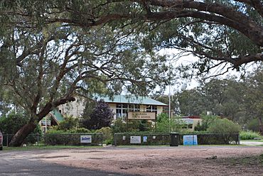
Karara State School
|
|||||||||||||||
| Population | 128 (2021 census) | ||||||||||||||
| • Density | 0.3625/km2 (0.939/sq mi) | ||||||||||||||
| Postcode(s) | 4352 | ||||||||||||||
| Elevation | 477 m (1,565 ft) | ||||||||||||||
| Area | 353.1 km2 (136.3 sq mi) | ||||||||||||||
| Time zone | AEST (UTC+10:00) | ||||||||||||||
| Location | |||||||||||||||
| LGA(s) | Southern Downs Region | ||||||||||||||
| State electorate(s) | Southern Downs | ||||||||||||||
| Federal Division(s) | Maranoa | ||||||||||||||
|
|||||||||||||||
Karara is a small country town in Queensland, Australia. It is located in the Southern Downs Region. In 2021, about 128 people lived in Karara.
Contents
Karara's Location and Landscape
Karara is found on the Darling Downs, a large farming area. It sits along the Cunningham Highway. This highway is a major road that goes through the area. Karara is about 208 kilometers (129 miles) southwest of Brisbane, the capital city of Queensland.
The Toowoomba–Karara Road also connects to the highway. It goes north from Karara towards Leyburn and then on to Toowoomba.
Railways in Karara
A railway line, called the South Western railway line, also runs through Karara. It goes mostly next to the highway. There were once two train stations in the area:
- Durikai railway station
- Karara railway station
Today, neither the railway line nor the Karara train station are used anymore.
Natural Features of Karara
A large part of the southern and eastern areas of Karara is covered by the Durakai State Forest. This is a protected forest area. The rest of the land is mostly used for farming. Several small creeks flow through Karara from south to north. These creeks eventually join the Condamine River.
Karara's History
The name Karara is thought to come from an Aboriginal word. It is believed to be the Aboriginal name for Canal Creek, a local waterway.
Key Dates in Karara's History
- 1904: The South Western railway line was opened. This line connected Karara to Warwick.
- 1908: Karara State School first opened its doors on July 20.
- 1927: The Karara Post Office began operating on July 1. Before this, there was a smaller "receiving office" from 1909. The post office closed in 1990.
Karara's Population Over Time
The number of people living in Karara has changed over the years:
- 2006: The population was about 140 people.
- 2011: The population grew to 278 people.
- 2016: The population was 123 people.
- 2021: The population was 128 people.
Community Life in Karara
Karara has a few services and community groups for its residents.
Local Services
The Southern Downs Regional Council provides a mobile library service. This special library on wheels visits the Recreation Reserve in Karara. It brings books and other resources to the community.
Community Groups
The Karara branch of the Queensland Country Women's Association (QCWA) meets regularly. They gather at the Karara Public Hall, which is located at 33 School Street. The QCWA is a group that supports women and communities in rural areas.
Education in Karara
Karara State School is a government primary school for students from Prep to Year 6. It is located on Karara School Road.
Karara State School Details
- In 2017, the school had 5 students and 3 teachers.
- In 2018, the school had 8 students and 2 teachers.
Secondary Education Options
There are no high schools directly in Karara. Older students usually travel to nearby towns for their secondary education. Some of the closest government high schools include:
- Warwick State High School in Warwick (for Years 7-12)
- Inglewood State School in Inglewood (for Years 7-10)
- Millmerran State School in Millmerran (for Years 7-10)
- Clifton State High School in Clifton (for Years 7-12)
- Allora State School in Allora (for Years 7-10)
 | William Lucy |
 | Charles Hayes |
 | Cleveland Robinson |


