
Kin Kin facts for kids
Quick facts for kids Kin KinQueensland |
|||||||||||||||
|---|---|---|---|---|---|---|---|---|---|---|---|---|---|---|---|

The Country Life Hotel on Main Street, Kin Kin, 2018
|
|||||||||||||||

Kin Kin
Location in Queensland
|
|||||||||||||||
| Population | 844 (2021 census) | ||||||||||||||
| • Density | 8.560/km2 (22.17/sq mi) | ||||||||||||||
| Postcode(s) | 4571 | ||||||||||||||
| Elevation | 64 m (210 ft) | ||||||||||||||
| Area | 98.6 km2 (38.1 sq mi) | ||||||||||||||
| Time zone | AEST (UTC+10:00) | ||||||||||||||
| Location |
|
||||||||||||||
| LGA(s) | Shire of Noosa | ||||||||||||||
| State electorate(s) | Noosa | ||||||||||||||
| Federal Division(s) | Wide Bay | ||||||||||||||
|
|||||||||||||||
Kin Kin is a small country town in Queensland, Australia. It's part of the Shire of Noosa. In 2021, about 844 people lived there.
Contents
Discovering Kin Kin's Location
Kin Kin is a town in South East Queensland, located between Pomona to the south and Gympie to the north. It's a great spot for outdoor fun because it's close to Lake Cootharaba and the Great Sandy National Park.
Kin Kin is also part of the Noosa Biosphere. This is a special area recognized by UNESCO for its unique natural environment. To the west, you'll find Woondum National Park. This area has beautiful hills and mountains covered in eucalyptus forests and rainforests.
Kin Kin's Past: A Brief History
The name Kin Kin is thought to mean "plenty black ants." This is because small black ants are very common in the area. You can even see a large ant sculpture outside the local general store! Some people also believe the name comes from an Aboriginal word, kauin kauin, meaning "red soil."
Early Days and Farming Life
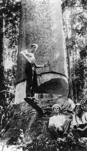
Timber workers first came to the Kin Kin area in the late 1870s. After that, it became a community focused on growing small crops and dairy farming. Over time, the way land was used changed, and there are now fewer large farms.
After World War 1, growing bananas became very popular. However, this industry declined in the 1930s when prices dropped. For many years, beans and zucchini were also important crops. But small-scale farming has decreased since the 1980s and is now done only a little.
Schools and Community Buildings
Several schools opened in the Kin Kin area long ago.
- Kin Kin State School first opened in 1909. It was later renamed Kin Kin Junction State School. The original school building was moved in 1986 and is now used as a community center.
- Moran Group Provisional School opened in 1910 and closed in 1952.
- Wahpunga State School opened in 1910 and closed in 1967. The site is now a park.
The Kin Kin School of Arts opened in 1911. It was a community building with a reading room, a library, and a hall for events.
Churches were also built in Kin Kin:
- Kin Kin Methodist Church opened in 1916. It later became the Kin Kin Uniting Church but closed in 2002.
- St Mary's Catholic Church opened in 1926 but was destroyed in a storm in 1985.
- St Luke's Anglican Church opened in 1926 but closed around 2020.
Weather Events and Changes
Kin Kin has experienced some severe weather over the years.
- In 1924, a big storm damaged the School of Arts hall, but it was rebuilt.
- In 1930, a tornado caused flash flooding and damaged many buildings and crops.
- Another tornado in 1932 affected many trees and buildings.
- A severe hailstorm in 1933 caused widespread damage to businesses and farms.
- In 1971, a tornado passed through the town, sadly causing fatalities and destroying homes.
- A hail storm and tornado in 1985 destroyed the Butter Factory and damaged other buildings.
- In 1994, another storm with large hail and a tornado caused damage.
- In 2009, the town experienced its highest flooding on record from Kin Kin Creek. This caused significant damage and loss.
The butter factory in Kin Kin closed in 1937. Over time, most dairy farms in the area also closed, with the last ones shutting down by 2012.
Horse Races and Local Government
From 1980 to 2004, the "Great Kin Kin Horse Race" and a carnival were held annually. This popular event took place on a hilly course near the Country Life Hotel. The horse ride has since been restarted as a fun social ride on the Noosa Trail Network.
Even though Kin Kin has always been part of the Shire of Noosa, for a few years (2008-2013), it was part of the Sunshine Coast Region. However, the Shire of Noosa was brought back in 2014 after residents voted for it.
People of Kin Kin: Demographics
The number of people living in Kin Kin has grown over the years:
- In 2006, there were 546 people.
- In 2011, the population was 694.
- In 2016, it grew to 764 people.
- In 2021, the population reached 844 people.
Historic Places: Heritage Listings
Kin Kin has several places that are listed for their historical importance:
- Kin Kin Masonic Lodge, Bowman Street
- St Luke's Anglican Church (now closed), Grady Street
- Kin Kin State School, Main Street
- Kin Kin Memorial School of Arts, Main Street
- Former Post Office, Main Street
- Former ES&A Bank and residence, Main Street
- Country Life Hotel, Corner Main Street & Wahpunga Road
- Kin Kin Junction Uniting Church (now a private home), Pomona Kin Kin Road
- Kin Kin Sawmill, 1 Sister Tree Creek Road
What People Do: Kin Kin's Economy
,_interior.jpg)
The Kin Kin Sawmill is still working today. Many of the original large farms have been divided into smaller "hobby farms." On these farms, people might grow fruit trees or raise horses and beef cattle.
Today, Kin Kin is home to health retreats, places to stay, small businesses, and artists. There's also a rock quarry and places that grow bush foods.
Learning in Kin Kin: Education

Kin Kin State School is a government primary school for students from Prep to Year 6. It's located on Main Street. In 2018, the school had 62 students and also offers a special education program.
There isn't a high school in Kin Kin. Older students usually go to Noosa District State High School. This school has two campuses:
Fun and Facilities: Amenities
Kin Kin has several useful and fun places for the community:
- The Shire of Noosa provides a mobile library service that visits the Kin Kin school every week.
- You can find public toilets and a playground in the park next to the Memorial School of Arts Hall.
- Wahpunga School Park also has public toilets, a barbecue, and a shelter.
- The Kin Kin Tennis Courts are located behind the Memorial School of Arts Hall.
- There's a skate park and public camping available on the oval behind the Country Life Hotel.
- The Kin Kin Arboretum, a special garden, is about 2.5 km south of the village.
Images for kids
-
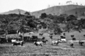
Illawarra Dairy Cattle on Mr G Grevetts farm at Kin Kin, circa 1931

