Como, Queensland facts for kids
Quick facts for kids ComoSunshine Coast, Queensland |
|||||||||||||||
|---|---|---|---|---|---|---|---|---|---|---|---|---|---|---|---|

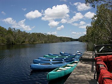
Kayaks on the Noosa River at Harry's Hut, 2011
|
|||||||||||||||
| Population | 54 (2021 census) | ||||||||||||||
| • Density | 0.520/km2 (1.35/sq mi) | ||||||||||||||
| Postcode(s) | 4571 | ||||||||||||||
| Elevation | 20 m (66 ft) | ||||||||||||||
| Area | 103.8 km2 (40.1 sq mi) | ||||||||||||||
| Time zone | AEST (UTC+10:00) | ||||||||||||||
| Location | |||||||||||||||
| LGA(s) | Shire of Noosa | ||||||||||||||
| State electorate(s) | Noosa | ||||||||||||||
| Federal Division(s) | Wide Bay | ||||||||||||||
|
|||||||||||||||
Como is a small, quiet area in Queensland, Australia. It's a rural locality, meaning it's mostly countryside, not a big city. In 2021, only 54 people lived here. Como is part of the Shire of Noosa, which is known for its beautiful natural areas.
Contents
Exploring Como's Location
Como is located on the sunny Sunshine Coast. It is about 48 kilometers (30 miles) north-west of Noosa Heads. The area sits right next to the border between the Shire of Noosa and the Gympie Region.
Natural Borders of Como
The Noosa River forms the north-east and eastern edges of Como. To the south-east, Como is bordered by the shores of Lake Cootharaba. These waterways make Como a very scenic place.
Protected Areas and Land Use
A large part of Como is made up of protected natural areas. Much of the eastern side is within the Great Sandy National Park. This park helps protect the natural environment. Some parts of the western side are in the Toolara State Forest. The south-west of Como has homes and land used for grazing animals and growing crops. The northern part of Como is also used for grazing.
A Glimpse into Como's Past
Historically, Como was an important area for logging timber. This means trees were cut down for wood. Many campsites and small towns were set up for the timber workers. Boats were the main way to transport both the timber and the workers.
The Story of Harry's Hut
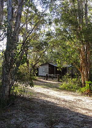
Harry's Hut was built in 1957. It was a simple shelter for timber workers to use when it rained heavily. After logging stopped in the 1960s, a man named Harry Spring bought the hut. He owned pharmacies nearby and used the hut as a base for fishing in the Noosa River. After Harry died in 1999, the hut became part of the National Parks department. It is still called Harry's Hut today.
Changes in Local Government
Between 2008 and 2013, Como was part of the Sunshine Coast Region. In 2008, the Queensland Government combined the Shire of Noosa with other areas. This created the new Sunshine Coast Region. However, the people who used to live in the Shire of Noosa voted to separate again. So, the Shire of Noosa was re-established in 2014.
Historic Places in Como
Como has a few special places that are listed as heritage sites. These sites are important because they tell us about the area's history.
- Elanda Point on Lake Cootharaba: Mill Point Settlement Site (26°14′52″S 153°00′00″E / 26.2478°S 153.0001°E)
- Lake Cootharaba (26°15′58″S 153°00′58″E / 26.266°S 153.016°E)
- Harry's Hut, Harrys Hut Road (26°11′29″S 153°01′48″E / 26.19126°S 153.02994°E)
Who Lives in Como?
The number of people living in Como is quite small.
- In 2016, Como had a population of 46 people.
- By 2021, the population had grown slightly to 54 people.
Como's Local Economy
Como is a rural area, and its economy includes some homesteads. These are large farms or properties where people live and work.
- Como Park (26°12′35″S 152°57′00″E / 26.2098°S 152.9500°E)
- Cootharaba (26°13′27″S 152°56′23″E / 26.2241°S 152.9397°E)
- Tarangau (26°10′39″S 152°58′53″E / 26.1775°S 152.9815°E)
Learning and Education Near Como
There are no schools directly in Como itself. Students usually travel to nearby towns for their education.
- The closest primary school is Kin Kin State School. It is located in Kin Kin, to the south-west of Como.
- For high school, students attend Noosa District State High School. This school has two campuses. The junior campus is in Pomona, and the senior campus is in Cooroy. Both are to the south-west of Como.
Fun Things to Do in Como
One of the main attractions in Como is the Harry's Hut recreational area. This spot is perfect for a day trip or for camping. It is located right on the banks of the Noosa River, within the Great Sandy National Park. You can find these facilities at the northern end of Harrys Hut Road.
 | Janet Taylor Pickett |
 | Synthia Saint James |
 | Howardena Pindell |
 | Faith Ringgold |


