
Cooran, Queensland facts for kids
Quick facts for kids CooranSunshine Coast, Queensland |
|||||||||||||||
|---|---|---|---|---|---|---|---|---|---|---|---|---|---|---|---|

Cooran Memorial School of Arts
|
|||||||||||||||

Cooran
Location in Queensland
|
|||||||||||||||
| Population | 1,756 (2021 census) | ||||||||||||||
| • Density | 46.33/km2 (120.0/sq mi) | ||||||||||||||
| Postcode(s) | 4569 | ||||||||||||||
| Elevation | 84 m (276 ft) | ||||||||||||||
| Area | 37.9 km2 (14.6 sq mi) | ||||||||||||||
| Time zone | AEST (UTC+10:00) | ||||||||||||||
| Location |
|
||||||||||||||
| LGA(s) | Shire of Noosa | ||||||||||||||
| State electorate(s) |
|
||||||||||||||
| Federal Division(s) | Wide Bay | ||||||||||||||
|
|||||||||||||||
Cooran is a small town located in the countryside of Queensland, Australia. It is part of the Shire of Noosa. In 2021, about 1,756 people lived here.
Contents
Where is Cooran Located?

Cooran is mostly farmland. The main part of the town is in the north. Several creeks flow through Cooran, like Pinbarren Creek, Six Mile Creek, and Coles Creek. All these creeks eventually flow into the Mary River.
The main highway, the Bruce Highway, goes through the edge of Cooran. But it does not go directly through the town. You can get to Cooran using roads like Traveston Road, Coles Creek Road, and Greenridge-Pinbarren Road.
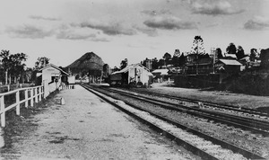
The North Coast railway line also runs through Cooran. The Cooran railway station is right in the middle of town.
What is Mount Cooran?
Mount Cooran is a very noticeable mountain peak in the area. It stands out in the landscape.
A Look at Cooran's Past
The name Cooran comes from the Kabi language. The word guran or kuran means tall. This might refer to Mount Cooran or the tall Moreton Bay Ash trees found here.
Cooran Lagoon and Early Life
Cooran Lagoon is a waterhole near the railway line. Aboriginal people used this lagoon for food. They would gather water-lily bulbs and mussels from it. The Indigenous name for the lagoon is Guran.
In 1878, a place called the Half Way Hotel was built near the lagoon. It was on the old coach road that went from Gympie to Tewantin. Later, in 1889, the hotel moved closer to the new Cooran railway station and was renamed the Cooran Hotel.
How Cooran Grew
The Cooran Post Office opened in 1889. A school, the Cooran Provisional School, started in 1890 and became Cooran State School in 1909.
In 1906, a man named William Martin built a large public hall. It had a big dance floor and a stage. This hall was a very important place for community events.
St Matthew's Anglican Church was opened in 1913. It was a place of worship for the community for many years.
Farming and Trails
In the 1920s and 1930s, growing bananas became a big business in Cooran. After World War II, pineapple farms also became popular.
In the early 2000s, the 26-kilometer Noosa Trail Network was created. This network of walking and biking trails now passes through Cooran.
Who Lives in Cooran?
The number of people living in Cooran has grown over the years.
- In 2011, about 1,457 people lived here.
- In 2016, the population was about 1,624 people.
- In 2021, the population reached 1,756 people.
Important Places in Cooran
Cooran has some important historical sites. One of these is Alfredson's Joinery at 28 King Street. It is a place that has been recognized for its special history.
Schools in Cooran
Cooran State School is a primary school for students from Prep to Year 6. It is located at 31 James Street. In 2018, the school had 134 students.
There isn't a high school directly in Cooran. Older students usually go to Noosa District State High School. This school has a campus in nearby Pomona for younger high school students and a campus in Cooroy for all high school years.
Community Spots and Services
The Cooran Memorial School of Arts is at 14 King Street. This hall is the oldest memorial hall in the Noosa area. It is used for many community events and activities.
The Shire of Noosa also provides a mobile library service. It visits King Street every week, bringing books and resources to the community.
What to Do in Cooran
Cooran has become a popular place for tourists. Many people enjoy driving through the scenic countryside here. The town has a community store, the memorial hall, and several nature reserves. It is surrounded by green valleys and is connected to the Cooroora and Woondum Trails.
Best Views in Cooran
The James M. McKane Memorial Lookout, also known as the Tablelands Lookout, offers amazing views. You can find it at 526 Tablelands Road.
