Kyiv Oblast facts for kids
Quick facts for kids
Kyiv Oblast
Київська область
Kiev Oblast
|
|||
|---|---|---|---|
| Kyivska oblast | |||
|
|||
| Nickname(s):
Київщина (Kyivshchyna)
|
|||
 |
|||
| Country | |||
| Administrative center | Kyiv | ||
| Area | |||
| • Total | 28,131 km2 (10,861 sq mi) | ||
| Area rank | Ranked 8th | ||
| Population
(2022)
|
|||
| • Total | |||
| • Rank | Ranked 10th | ||
| Demographics | |||
| • Average salary | UAH 4.174 (2011) | ||
| • Salary growth | +28.73 | ||
| Time zone | UTC+2 (EET) | ||
| • Summer (DST) | UTC+3 (EEST) | ||
| Postal code |
07-09
|
||
| Area code | +380 44 (Kyiv city) +380 45 (outside Kyiv city) |
||
| ISO 3166 code | UA-32 | ||
| Vehicle registration | AI | ||
| Raions | 7 | ||
| Cities (total) | 26 | ||
| • Regional cities | 12 | ||
| Urban-type settlements | 30 | ||
| Villages | 1,127 | ||
| FIPS 10-4 | UP13 | ||
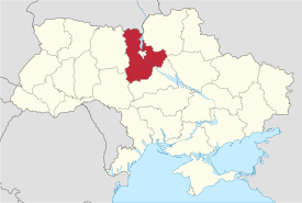
Kyiv Oblast (also called Kyivshchyna) is a large region, or oblast, in central and northern Ukraine. It completely surrounds the capital city, Kyiv, but Kyiv itself is a separate city with special status. Even so, Kyiv is the main administrative center for the oblast. Many people in Kyiv Oblast depend on Kyiv city for jobs and transportation.
About 1.8 million people live in Kyiv Oblast. The biggest city in the region is Bila Tserkva, which has over 200,000 residents.
A special area called the Chernobyl Exclusion Zone is in the northern part of Kyiv Oblast. This zone is managed separately, and people are not allowed to enter it.
Contents
A Look at History
Kyiv Oblast was first created on February 27, 1932. It was one of the first five regions in Ukraine when it was part of the Ukrainian Soviet Socialist Republic. This area was historically known as Ruthenian land.
Before that, the land was part of different historical units. These included the Kiev Voivodeship under the Polish–Lithuanian Commonwealth and the Grand Duchy of Lithuania. Later, it was part of the Kiev Viceroyalty and Kiev Governorate under the Russian Empire. The northern part of the oblast is also part of the historical region called Polesia.
In the Kyiv region, there was a unique style of icon painting. It was greatly influenced by the Kyiv Pechersk Lavra painting school. Saints were often painted on dark backgrounds, with dark clothes and dark halos outlined in thin white dots. You can see a collection of these icons at the Museum of Ukrainian home icons in the "The Radomysl Castle".
The current borders of Kyiv Oblast were set after the Chernobyl disaster in 1986. The city of Slavutych, built after the disaster, was moved under Kyiv Oblast's control, even though it is located in a different region.
On February 24, 2022, Russian Armed Forces entered Kyiv Oblast as part of the 2022 Russian invasion of Ukraine. Ukrainian forces fought back in March 2022. The region was declared free of invaders on April 2, 2022. Ukrainian troops retook over 30 towns and villages around Kyiv. However, on April 9, 2022, Russian forces attacked the Oblast again, damaging a railway station in Bucha.
Exploring the Geography
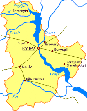
Kyiv Oblast covers about 28,100 square kilometers (about 10,850 square miles). It is located in north-central Ukraine. To the west, it borders the Zhytomyr Oblast. To the southwest, it borders Vinnytsia Oblast. To the south, it borders Cherkasy Oblast. To the southeast, it borders Poltava Oblast. To the east and northeast, it borders Chernihiv Oblast. To the north, it borders the Homyel Voblasts of Belarus.
The famous Dnieper River (also called Dnipro) flows through the oblast, splitting it into two parts. Other important rivers in the region are smaller rivers that flow into the Dnieper. These include the Pripyat, Desna, Teteriv, Irpin', Ros', and Trubizh.
The Dnieper River stretches for 246 kilometers (153 miles) within the oblast. The region has 177 rivers, 13 reservoirs (like the Kyiv Reservoir and Kaniv Reservoir), over 2,000 ponds, and about 750 small lakes.
Climate and Nature
The climate in Kyiv Oblast is typical for forested areas. It has a moderate continental climate. This means winters are usually mild, and summers are warm. Temperatures range from about -6.1°C (21°F) in January to 19.2°C (66.6°F) in July.
Kyiv Oblast has small mountains and slopes on the right side of the Dnieper River. This area is surrounded by many green spaces and forests. The "green area" of the oblast covers 436 square kilometers (168 square miles). It is home to 250 different types of trees and bushes.
Interesting Places to Visit
Several historical and cultural sites in Kyiv Oblast were nominated for the "Seven Wonders of Ukraine." These include:
- Pereiaslav museum of folk architecture
- Liutych platzdarm
- Ivan Kozlovsky villa
- Dobranychivka settlement
- Saint Pokrov Church (Parkhomivka)
- Museum-villa of Ekaterina Bilokur
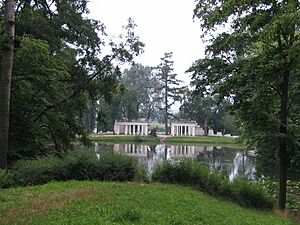
- Landscape garden Oleksandria
How Kyiv Oblast is Organized
The oblast is divided into 7 main districts called raions.
| Flag | Coat
of arms |
Name | Ukrainian Name | Administrative center | Area (km2) |
Population estimate 2021 |
|---|---|---|---|---|---|---|
| Bila Tserkva Raion | Білоцерківський район | Bila Tserkva | 6,514.8 | 436,115 | ||
| Boryspil Raion | Бориспільський район | Boryspil | 3,873.2 | 203,273 | ||
| Brovary Raion | Броварський район | Brovary | 2,881.9 | 242,180 | ||
| - | - | Bucha Raion | Бучаньский район | Bucha | 2,558.3 | 362,382 |
| Fastiv Raion | Фастівський район | Fastiv | 1,761.2 | 183,794 | ||
| Obukhiv Raion | Обухівський район | Obukhiv | 3,639.1 | 228,829 | ||
| Vyshhorod Raion | Вишгородський район | Vyshhorod | - | 131,957 | ||
| Total Oblast | Київська область | Kyiv | 28,131 | 1,788,530 |
Before a reform in July 2020, the oblast had 25 raions. It includes 26 cities, 30 towns, and over 1,000 villages.
The head of the Kyiv Oblast State Administration, also known as the governor, is chosen by the President of Ukraine. The local government is the Kyiv Oblast Rada, which is elected by the people.
Special Areas: Exclaves and Chernobyl Zone
The city of Slavutych is an interesting case. It is located within the borders of the neighboring Chernihiv Oblast, but it is managed by the Kyiv Oblast authorities. This makes it an administrative exclave, meaning it's a part of Kyiv Oblast that is separated from the main territory.
Similarly, the town of Kotsiubynske is inside Kyiv city limits, but it is managed by the Irpin city council.
The north-western part of the oblast is within the Chernobyl Exclusion Zone. This area was affected by radioactive contamination from the Chernobyl nuclear reactor accident. The largest cities in this zone, Chernobyl and Prypiat, are now abandoned. Slavutych was built outside this zone to house people who had to leave Prypiat and workers for the zone's facilities.
Major Cities and Towns
Some important cities and towns in Kyiv Oblast are:
- Bila Tserkva – a key industrial city with a rich history.
- Brovary – an important industrial center.
- Boryspil – home to Ukraine's main international airport and an industrial hub.
- Fastiv – a major railway center and industrial city.
- Irpin-Bucha-Vorzel – a group of connected towns.
- Pereiaslav – a historic place that attracts tourists.
- Slavutych – Ukraine's newest city, where many workers from the Chernobyl Nuclear Power Plant live.
- Vasylkiv – an industrial center with a large air base.
- Vyshhorod – where the Kyiv Hydroelectric Power Plant is located.
The biggest settlements by population (in thousands) are:
- Bila Tserkva – 200,100 people
- Brovary – 86,800 people
- Boryspil – 54,000 people (not including two nearby villages)
- Fastiv – 52,000 people
- Irpin – 40,600 people (not including four nearby towns)
People of Kyiv Oblast
The largest group of people in Kyiv Oblast are Ukrainians, making up about 92.5% of the population. Other groups include Russians, Jews, Belarusians, and Poles. As of 2013, the estimated population (not counting Kyiv city) was around 1.72 million. This means there are about 63 people per square kilometer.
According to the 2001 Ukrainian Census, about 57.6% of the population lived in cities, and 42.4% lived in rural areas.
Economy and Jobs
Industries in the Region
Kyiv Oblast has several important industries. These include power production, food processing, chemical and petrochemical industries, and mechanical engineering. The region produces a large share of Ukraine's tires (63%), excavators (53%), paper and cardboard (40%), and hoisting cranes (39%). Overall, there are 330 large industrial businesses and 742 smaller ones. The Boryspil Bus Plant, located in Prolisky, makes 1,700 buses each year. Other car-related factories are also in the oblast.
Farming and Agriculture
Besides industry, farming is also very important in Kyiv Oblast. In 1999, the region produced about 1.1 million tons of grain, 1.5 million tons of sugar beets, 18,100 tons of sunflower seeds, and 669,200 tons of potatoes. The region also produced 156,900 tons of meat, 738,500 tons of milk, and 855.2 million eggs. In early 1999, there were 1,130 registered farms in the oblast.
Getting Around: Transportation
Kyiv Oblast has a very good railway system. The total length of railway lines in the oblast was 88 kilometers (55 miles) in 1985. Major railway routes pass through the region, connecting cities like Moscow, Kyiv, Lviv, Dnipro, and Donetsk. There are also local train lines, called Elektrychka, that connect Kyiv to nearby towns like Fastiv, Teteriv, Nizhyn, and Yahotyn.
The oblast has 7,760 kilometers (4,822 miles) of roads, with 7,489 kilometers (4,653 miles) of them paved. Important roads that cross the oblast include:
- Saint Petersburg—Kyiv—Odesa (M-01/M-05 routes)
- Kyiv-Kovel-Lublin (M-07 route)
- Voronezh—Kharkiv-Kyiv-Lviv-Kraków (E-40, M-06/M03 routes)
- Luhansk-Dnipro-Kyiv (M-04 route)
The main airports in the oblast are two international airports: the Boryspil Airport and the Hostomel (Antonov) Cargo Airport. The Ukrainian military also has airbases in Bila Tserkva and Uzyn.
Important gas pipelines, like the Urengoy–Pomary–Uzhhorod pipeline and the Shebelynka—Poltava—Kyiv pipeline, also run through the oblast.
Learning and Education
Kyiv Oblast has 795 public schools. About 27.5% of these are in cities, and 72.5% are in rural areas. These schools teach 232,260 students. There are also 12 evening schools, 15 private schools, 23 vocational schools (for job training), and 22 higher education schools (colleges/universities). Additionally, there are 756 pre-school institutions for young children.
The oblast also has special schools for orphans and children with physical or mental disabilities.
For students with special talents, there are unique educational institutions:
- Fastiv Regional Natural and Mathematic School
- Kyiv Regional Lyceum of Physical Education and Sports
- Stritiv Higher Pedagogical School of Kobza Music (for traditional Ukrainian music)
- Brovary Higher School of Physical Education (which has trained many world and Olympic champions).
How the Oblast Got its Name
Most regions in Ukraine are named after their main city, which is called the "oblast center." The name of each oblast is like an adjective formed from the city's name. For example, Kyiv is the center of the Kyivs’ka oblast' (Kyiv Oblast). Many oblasts also have a traditional name ending with "-shchyna," like Kyivshchyna for Kyiv Oblast.
See also
 In Spanish: Óblast de Kiev para niños
- List of villages in Kyiv Oblast
- Subdivisions of Ukraine
- Radomysl Castle
 | Kyle Baker |
 | Joseph Yoakum |
 | Laura Wheeler Waring |
 | Henry Ossawa Tanner |


