
La Brévine facts for kids
Quick facts for kids
La Brévine
|
||
|---|---|---|

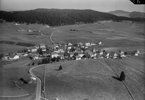
Southwest view of La Brévine
|
||
|
||

La Brévine
Location in Switzerland

La Brévine
Location in Canton of Neuchâtel
|
||
| Country | Switzerland | |
| Canton | Neuchâtel | |
| Area | ||
| • Total | 41.81 km2 (16.14 sq mi) | |
| Elevation | 1,043 m (3,422 ft) | |
| Population
(Dec 2020 )
|
||
| • Total | 624 | |
| • Density | 14.925/km2 (38.65/sq mi) | |
| Postal code |
2406
|
|
| Surrounded by | Boveresse, Couvet, Grand'Combe-Châteleu (FR-25), Hauterive-la-Fresse (FR-25), La Chaux-du-Milieu, Le Cerneux-Péquignot, Les Bayards, Les Gras (FR-25), Les Ponts-de-Martel, Montbenoît (FR-25), Saint-Sulpice, Travers, Ville-du-Pont (FR-25) | |
| Twin towns | Leynes (France) | |

La Brévine is a village and a municipality in the Neuchâtel Canton in Switzerland. It is the biggest village in its valley, which is also called Vallée de la Brévine. This area is famous for its special weather, which is often much colder than places nearby.
Contents
Exploring La Brévine's Past
The early history of La Brévine is a bit of a mystery, mixed with old stories and guesses. People from the Val de Travers started settling in the Vallée de la Brévine around the 1200s. Later, in the 1300s, people from Burgundy (a region in France) also moved here.
What Does "La Brévine" Mean?
The name La Brévine has a debated meaning. Some people think it comes from a French word meaning "watering hole" for animals. Others believe it comes from an old Celtic word meaning "beaver stream."
Village Growth and Discoveries
In the 1600s, the name "La Brévine" only referred to the main village. It wasn't until the 1700s that the name was used for the whole municipality. Small settlements, called hamlets, like Bémont and Les Taillères, were mentioned even earlier, around the 1200s and 1300s.
Around the mid-1600s, a type of iron called iron carbonate was found in La Brévine. In the mid-1800s, baths were built there, helped by King Frédéric-Guillaume IV of Prussia. These baths are no longer open today.
Discovering La Brévine's Landscape

La Brévine covers an area of about 41.8 square kilometers (16 square miles). More than half of this land, about 53.6%, is used for farming. A large part, 42.5%, is covered by forests.
Land Use in La Brévine
A small part of the land, 2.3%, has buildings or roads. About 1% is made up of rivers or lakes. The rest, also about 1%, is land that cannot be used for farming or building.
Most of the forested land is dense forest. Some areas have orchards or small groups of trees. For farming, most of the land is used for pastures where animals graze. All the water in the municipality is found in lakes.
Location and Settlements
La Brévine is located close to the French border. The main village of La Brévine is about 1,046 meters (3,432 feet) above sea level. The municipality also includes smaller hamlets like Le Brouillet, Bémont, Les Taillères, and La Châtagne, along with many scattered farmhouses.
The biggest lake in the valley, the Lac des Taillères, is about 2 kilometers (1.25 miles) from the village. The highest point in the valley, the Crêt du Cervelet, is about 3 kilometers (2 miles) from the town.
La Brévine's Coat of Arms
The official symbol, or coat of arms, for La Brévine shows a silver fountain on a blue background, with a gold border.
Who Lives in La Brévine?
La Brévine has a population of about 692 people (as of December 2007). A small number of these residents, about 3.2%, are foreign nationals. Over the 2000s, the population stayed mostly the same.
Languages Spoken in La Brévine
Most people in La Brévine speak French as their main language, about 95.2% of the population. The second most common language is German, spoken by about 3.4% of the people. A few people also speak Portuguese.
Where People Come From
About half of the people living in La Brévine were born there. About 26% were born in the same canton (Neuchâtel). Around 13% were born in other parts of Switzerland, and about 4.3% were born outside of Switzerland.
Age Groups in the Community
In La Brévine, children and teenagers (up to 19 years old) make up about 27.5% of the population. Adults (20 to 64 years old) make up 56.1%, and seniors (over 64 years old) make up 16.4%.
Households and Homes
There are about 249 private households in La Brévine, with an average of 2.6 people living in each home. About 66 households have only one person, and 30 families have five or more people. Most apartments (72.4%) are lived in all year, while some are used only during certain seasons.
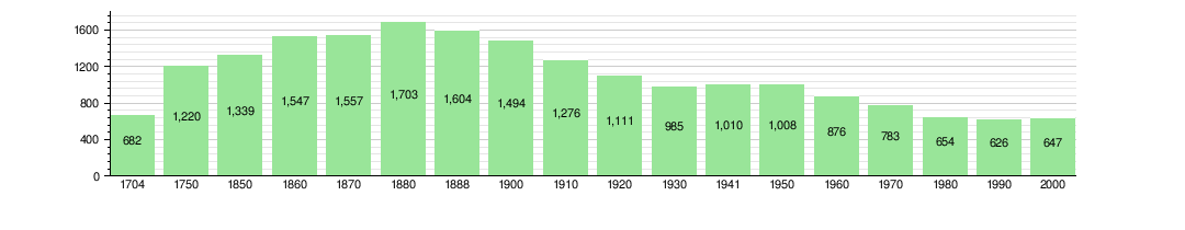
Population Changes Over Time
The chart below shows how the population of La Brévine has changed over many years:
Important Buildings in La Brévine

The Double House, also called La Grosse Maison, is a very important building in La Brévine. It is listed as a Swiss heritage site of national significance. This means it's a special place protected for its history and importance.
How People Make a Living in La Brévine
In La Brévine, people work in different types of jobs. As of 2010, the unemployment rate was low, at 1.1%.
Main Job Sectors
- Primary Sector: This includes jobs like farming, which is very common here. About 157 people work in this sector.
- Secondary Sector: This involves making things, like in factories, or building things, like construction. About 60 people work in this sector.
- Tertiary Sector: These are service jobs, like working in shops, restaurants, or schools. About 105 people work in this sector.
Many people who live in La Brévine also work there. However, more people travel out of the municipality for work than those who come in. About 42.2% of workers use a private car to get to their jobs.
Religion in La Brévine
Based on a 2000 survey, most people in La Brévine belong to the Swiss Reformed Church, about 69.1%. About 16.5% are Roman Catholic. A small number of people belong to other Christian churches or have no religious beliefs.
La Brévine's Unique Climate
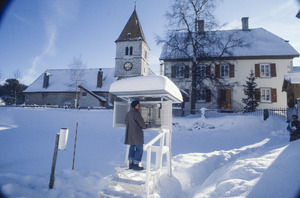
La Brévine is often called the “Siberia of Switzerland.” This is because it gets extremely cold there. It holds the record for the lowest temperature ever officially measured in an inhabited place in Switzerland.
Record Cold Temperatures
On January 12, 1987, the local weather station recorded a temperature of -41.8 °C (-43.2 °F). This is the coldest temperature ever officially recorded by MeteoSwiss in Switzerland. For comparison, the hottest temperature recorded in Switzerland was 41.5 °C (106.7 °F) in Grono.
While La Brévine is famous for its cold, some towns high in the Alps, like Samedan, are generally colder. The official coldest place in Switzerland is the Jungfraujoch, which is a research station high in the mountains.
Weather Patterns in La Brévine
La Brévine has a climate with mild, rainy summers and very cold, snowy winters. On average, it has about 143.8 days of rain or snow each year. The total amount of rain and snow is about 1,295 mm (51 inches) per year.
The wettest month is July, with about 131 mm (5.2 inches) of rain or snow. The month with the most days of precipitation is May. February is usually the driest month.
| Climate data for La Brévine: 1050m (1991-2020) | |||||||||||||
|---|---|---|---|---|---|---|---|---|---|---|---|---|---|
| Month | Jan | Feb | Mar | Apr | May | Jun | Jul | Aug | Sep | Oct | Nov | Dec | Year |
| Mean daily maximum °C (°F) | 1.4 (34.5) |
2.4 (36.3) |
6.3 (43.3) |
10.7 (51.3) |
14.8 (58.6) |
18.8 (65.8) |
20.8 (69.4) |
20.6 (69.1) |
16.3 (61.3) |
12.5 (54.5) |
6.4 (43.5) |
2.5 (36.5) |
11.1 (52.0) |
| Daily mean °C (°F) | −3.5 (25.7) |
−3.2 (26.2) |
0.8 (33.4) |
4.6 (40.3) |
8.9 (48.0) |
12.5 (54.5) |
14.4 (57.9) |
13.8 (56.8) |
10.0 (50.0) |
6.5 (43.7) |
1.4 (34.5) |
−2.1 (28.2) |
5.3 (41.5) |
| Mean daily minimum °C (°F) | −9.4 (15.1) |
−9.8 (14.4) |
−5.4 (22.3) |
−2.3 (27.9) |
1.7 (35.1) |
5.1 (41.2) |
6.7 (44.1) |
6.2 (43.2) |
3.4 (38.1) |
0.6 (33.1) |
−4.0 (24.8) |
−7.6 (18.3) |
−1.2 (29.8) |
| Average precipitation mm (inches) | 86 (3.4) |
79 (3.1) |
85 (3.3) |
96 (3.8) |
128 (5.0) |
122 (4.8) |
131 (5.2) |
118 (4.6) |
114 (4.5) |
115 (4.5) |
108 (4.3) |
114 (4.5) |
1,295 (51.0) |
| Average snowfall cm (inches) | 68.4 (26.9) |
68.3 (26.9) |
54.4 (21.4) |
23.8 (9.4) |
4.2 (1.7) |
0.0 (0.0) |
0.0 (0.0) |
0.0 (0.0) |
0.0 (0.0) |
2.4 (0.9) |
29.7 (11.7) |
56.4 (22.2) |
307.6 (121.1) |
| Average precipitation days (≥ 1.0 mm) | 12.2 | 11.2 | 11.4 | 11.6 | 14.2 | 11.8 | 11.9 | 11.4 | 10.6 | 12.4 | 12.0 | 13.1 | 143.8 |
| Average snowy days (≥ 1.0 cm) | 9.4 | 9.1 | 7.9 | 4.7 | 0.9 | 0.0 | 0.0 | 0.0 | 0.0 | 1.2 | 4.7 | 8.1 | 46.0 |
| Average relative humidity (%) | 86 | 84 | 81 | 78 | 79 | 78 | 78 | 79 | 83 | 84 | 86 | 86 | 82 |
| Source: MeteoSwiss (snow 1981–2010) | |||||||||||||
Learning in La Brévine: Education
In La Brévine, many people have completed their education. About 29.5% of the population has finished high school. A smaller group, about 6.6%, has gone on to higher education, like university.
School System in Neuchâtel
In the canton of Neuchâtel, where La Brévine is located, most towns offer two years of optional kindergarten. After that, there are five years of required primary school. Then, students go to larger secondary schools for four more years of compulsory education. Students often travel to other towns for secondary school.
During the 2010-2011 school year, La Brévine had one kindergarten class with 11 students. It also had two primary classes with 40 students. Some students from La Brévine attend schools outside the municipality.
See also
 In Spanish: La Brévine para niños
