Lake Souris facts for kids
Quick facts for kids Lake Souris |
|
|---|---|

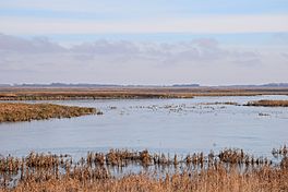
A few ducks and swans rest in the marsh at J. Clark Salyer NWR.
|
|
| Location | Souris River |
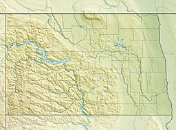
| Coordinates | 48°31′N 100°28′W / 48.52°N 100.47°W |
| Lake type | former lake |
| Basin countries | Canada United States |
| Max. length | 170 mi (270 km) |
| Max. width | 70 mi (110 km) |
| Surface elevation | 1,600 ft (488 m) |
Glacial Lake Souris was a huge ancient lake. It formed during the Ice Age when giant glaciers melted. This lake covered a large area where the Souris River flows today. It stretched from North Dakota in the United States all the way to Manitoba, Canada.
Lake Souris was about 170 miles (274 km) long. At its widest point, it was nearly 70 miles (113 km) across. This ancient lake was located near another massive glacial lake called Lake Agassiz. A smaller lake, Glacial Lake Hind, separated them.
An arm of Lake Souris also reached along the Assiniboine River. This part of the lake went from Griswold and Oak Lake in Manitoba. It even extended into Saskatchewan. The lake's main body curved around Turtle Mountain. It also formed a large terrace on the west side, known as the Coteau du Missouri.
The water from Lake Souris first flowed out into Lake Agassiz. This happened through the Big Coulée River and the Sheyenne River. Over time, the outflow channel got deeper. Later, the lake's water found a new path. This new path went through Pelican Lake and along the Pembina River. Eventually, all the water from Lake Souris drained away through this new outlet.
Contents
The North Dakota Gold Rush and Lake Souris
Since the early 1900s, people have found gold in the sand and gravel. These deposits are linked to the ancient Glacial Lake Souris. This happened in McHenry County, Bottineau County, and Pierce County in North Dakota.
First Gold Discoveries
The first time gold was found here was likely in May 1908. Mining claims were made about three miles east of Denbigh, a town in McHenry County. Later in 1908, a company called the Eldorado Gold Mining Company was started. Their goal was to buy a dredge or a special mining boat. This boat would help them search for gold. Other similar companies also formed around this time. However, finding gold turned out to be very difficult. The companies soon closed down and left the area.
Gold Rediscovered in the 1930s
The gold-bearing deposits were found again in 1931. Reports from Chicago said that gold nuggets were found in the crops of turkeys! These turkeys were raised near Denbigh. After this news, many people and groups filed claims. They took mining leases. Soon, almost all the land around Denbigh and Towner was covered by these claims.
Where Did the Gold Come From?
The gold found in Lake Souris's gravel deposits came from rocks far away. These rocks are part of the Canadian Shield to the north. The glaciers that carried the gold flowed over areas that are now mining districts. These include Gods Lake, Flin Flon, and Lac La Ronge in northern Manitoba and Saskatchewan.
This part of the Canadian Shield is about 500 miles (805 km) north of the Denbigh area. Based on how the glaciers moved, this area is a likely source for the gold. After the glaciers melted, they dropped their sediments. Streams of meltwater then washed these sediments. This washing helped to gather the gold together. The gold-bearing sediments settled on the bottom of Lake Souris. They formed fan-shaped deposits near the mouths of rivers like the Souris River.
 | Aurelia Browder |
 | Nannie Helen Burroughs |
 | Michelle Alexander |


