
Lake Taupō facts for kids
Quick facts for kids Lake Taupō |
|
|---|---|
| Lake Taupo | |
 |
|

Lake Taupō
Location in New Zealand

Lake Taupō
Location in North Island
|
|
| Location | Taupō District, Waikato region, North Island |
| Coordinates | 38°48′25″S 175°54′28″E / 38.80694°S 175.90778°E |
| Type | Crater lake, oligotrophic |
| Native name |
|
| Etymology | From Taupō-nui-a-Tia, Māori for "great cloak of Tia" |
| Primary inflows | Waitahanui River, Tongariro River, Tauranga Taupō River |
| Primary outflows | Waikato River |
| Catchment area | 3,487 km2 (1,346 sq mi) |
| Basin countries | New Zealand |
| Max. length | 46 km (29 mi) |
| Max. width | 33 km (21 mi) |
| Surface area | 616 km2 (238 sq mi) |
| Average depth | 110 m (360 ft) |
| Max. depth | 186 m (610 ft) |
| Water volume | 67.76 km3 (16.26 cu mi) |
| Residence time | 10.5 years |
| Shore length1 | 193 km (120 mi) |
| Surface elevation | 356 m (1,168 ft) |
| Islands | Motutaiko Island (11 ha) |
| 1 Shore length is not a well-defined measure. | |
Lake Taupō (also spelled Taupo) is a very large lake in New Zealand's North Island. It sits inside a huge bowl called a caldera, which was formed by a powerful volcano called Taupō Volcano. The town of Taupō is named after the lake and is located on its northeastern shore.
Lake Taupō is the largest lake in New Zealand by surface area, covering about 616 square kilometers. It is also the second largest freshwater lake in Oceania. A small island called Motutaiko Island can be found in the southeastern part of the lake.
Contents
Geography of Lake Taupō
Lake Taupō has a shoreline that stretches for about 193 kilometers. At its deepest point, the lake is about 186 meters deep. The Waikato River, which is New Zealand's longest river, flows out of Lake Taupō. The main rivers that flow into the lake are the Waitahanui River, the Tongariro River, and the Tauranga Taupō River.
The lake is famous for its trout fishing. Many brown and rainbow trout, which were brought from other countries, live here. The water level of Lake Taupō is carefully managed by a company called Mercury Energy. They use special gates to control the water flowing into the Waikato River. This helps prevent floods, saves water, and makes sure the river always has enough water.
How Lake Taupō Formed
Lake Taupō is located in a caldera. This is a large bowl-shaped hollow that forms when the ground collapses after a huge volcanic eruption. The Taupō Volcano is a supervolcano, meaning it can have extremely powerful eruptions.
Major Volcanic Eruptions
The Taupō Volcano has been active for about 300,000 years. Over the last 30,000 years, it has erupted 29 times.
- The Oruanui Eruption: The biggest known eruption happened about 25,600 years ago. It was the largest eruption in the world over the past 70,000 years. This eruption threw out a massive amount of material. It caused hundreds of square kilometers of land to collapse, forming the caldera that later filled with water to become Lake Taupō.
- The Hatepe Eruption: The most recent major eruption happened around 232 CE. This was one of the most powerful eruptions in the last 5,000 years. It ejected a huge amount of material in just a few minutes. This eruption made the lake even bigger. Historical records from Rome and China around that time mention a red sky, which might have been caused by this eruption. At the time, no humans lived in New Zealand.
The Taupō Volcano is still considered active. Scientists from GNS Science keep a close eye on it. Even today, you can find hot springs and underwater hot spots around the lake. These areas are home to tiny living things called extremophiles, which can survive in very hot places.
Animals and Plants
The land around Lake Taupō is covered in forests. These forests have many different types of trees, like beech and podocarp trees. There are also many ferns and shrubs growing underneath the trees.
Lake Animals
The lake is home to native animals like the northern kōura (a type of crayfish) and kōkopu (a type of fish also known as whitebait). As mentioned, the lake is well-known for its brown trout and rainbow trout. These fish were brought to New Zealand from Europe and California in the late 1800s. Smelt, a smaller fish, were also introduced to the lake to provide food for the trout.
Around the underwater hot spots, there are communities of sponges and other small creatures that live in the warm water.
Tourism and Activities
Tourism is a very important part of the economy in Taupō. Many visitors come during the summer holidays around Christmas and New Year.
The weather around the lake is mild. In January and February, the average daily high temperature is about 23.3°C. In July, it's cooler, around 11.2°C. It rains throughout the year, but more often in winter and spring.
Many fun events and activities happen around Lake Taupō:
- Lake Taupo Cycle Challenge: This is a cycling event where people ride their bikes all the way around the lake.
- Skydiving: Jumping out of a plane is a popular activity for both locals and tourists.
- Ironman Triathlon: Taupō also hosts a famous Ironman event, which involves swimming, cycling, and running.
- Open-water swimming: Some brave swimmers try to swim across the entire 40.2-kilometer length of the lake.
Māori Rock Carvings

On the cliffs of Mine Bay, on the northwest side of Lake Taupō, you can see amazing Māori rock carvings. These carvings were made in the late 1970s by artists Matahi Whakataka-Brightwell and John Randall.
The main carving is over 10 meters tall and shows Ngātoro-i-rangi. He was a very important navigator in Māori legend who guided the Tūwharetoa and Te Arawa tribes to the Taupō area over a thousand years ago. The carvings are meant to protect Lake Taupō from volcanic activity. Many boats and kayaks visit this spot every year.
Māori Tribes and Ownership
Lake Taupō is considered a taonga (a special treasure) by the Ngāti Tūwharetoa tribe. This tribe owns the bed of the lake and the rivers that flow into it. They allow everyone to use the lake for fun activities for free.
History of the Lake Area
A Ngāti Tūwharetoa village called Te Rapa used to be located near Lake Taupō. However, on May 7, 1846, a landslide covered the village. About 60 people died in this event, including the tribe's chief, Mananui Te Heuheu Tūkino II.
Images for kids
-
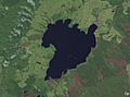
NASA satellite photo of Lake Taupō
-
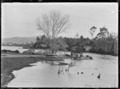
Wharf and small jetty where the Waikato River departs the lake, 1928


See also
 In Spanish: Lago Taupo para niños
