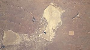
Lake Thompson (California) facts for kids
Lake Thompson was a huge ancient lake in California. It existed during the Pleistocene epoch, also known as the Ice Age. This large lake covered much of the lower Antelope Valley, including the areas where Rogers Lake and Rosamond Lake are found today. The lake dried up during the Holocene epoch, which is our current warmer period. The name "Lake Thompson" comes from a scientist who first thought a lake might have existed there.
Contents
Ancient Lakes of North America
During the Ice Age, many large lakes formed in the deserts of North America. These included famous lakes like Lake Bonneville in Utah and Lake Lahontan in Nevada. Other lakes, such as Lake Mojave and Lake Manly, also appeared in California.
Why These Lakes Formed
These lakes grew because of colder periods during the last glacial maximum (the peak of the last Ice Age). The cooler temperatures meant less water evaporated from the land. Also, storm paths shifted south because of the huge ice sheets covering much of the continent. This brought more rain and snow to the desert regions, filling up the lake basins.
The Mighty Lake Thompson
Lake Thompson was shaped a bit like a kidney. It covered a massive area of about 950 square kilometers (about 367 square miles). This means it was much larger than many modern lakes! It stretched across a big part of the western Mojave Desert, reaching elevations of up to 710 meters (about 2,330 feet).
Features of the Lake
The lake had two islands within its waters. Along its old shorelines, you can still see cliffs that were carved by the water. There are also sand dunes in the area, formed after the lake dried up.
Life in and Around the Lake
Scientists have found evidence of many different animals that lived in or near Lake Thompson. These include Stickleback fish, which might have entered the lake from other river systems. The lake sediments also contain fossils of snails, other types of fish, amphibians, reptiles, birds, and even large mammoths!
Modern Towns on the Lake Bed
Today, several towns are built right on what used to be the bottom of Lake Thompson. These include Boron, California, Kramer, California, Lancaster, California, and Rosamond, California. Over time, new sediments from rivers and growing towns have covered many of the lake's old shorelines.
How Lake Thompson Was Fed
The area that drained into Lake Thompson was very large, covering about 5,633 square kilometers (about 2,175 square miles). This area is surrounded by the San Gabriel Mountains to the south and the Tehachapi Mountains to the west.
Water Sources
Several creeks flowed down from these mountains, bringing water into the lake. For example, Little Rock Creek was one of its many tributaries. When the water level reached about 710 meters (2,330 feet), the lake would have been quite deep, possibly around 70 meters (230 feet) in its deepest parts.
Possible Overflow Points
It's possible that Lake Thompson sometimes overflowed its banks. One idea is that it might have spilled northwards into the Fremont Valley. However, the land there is quite high now, so it would have needed a very full lake to overflow. Another less likely idea is that it might have overflowed eastward, near Boron, California, towards the Mojave River or Lake Harper.
The History of Lake Thompson
The basin where Lake Thompson formed has seen lakes come and go many times over millions of years, especially during the Cenozoic Era.
Lake Level Changes
Scientists believe there were deep lakes in this area around 36,000 years ago, and again between 16,200 and 12,600 years ago. There were also shallower lakes between 26,000 and 21,000 years ago. The lake dried up completely at certain times, like between 21,000 and 16,200 years ago, and then fully during the Holocene (our current warm period). There might have even been a small increase in the lake's water level about 7,700 years ago.
The Lake Today
Lake Thompson no longer exists because our climate is much drier now. However, during very wet winters, parts of its old lakebed can still flood. Rogers Lake, Rosamond Lake, and Buckskin Lake are all located on the former bed of Lake Thompson. The rest of the old lakebed is covered with sediments that were deposited by the lake itself, as well as by rivers and wind.


