Lake Winnipegosis facts for kids
Quick facts for kids Lake Winnipegosis |
|
|---|---|
 |
|
| Location | Manitoba |
| Coordinates | 52°30′N 100°00′W / 52.500°N 100.000°W |
| Lake type | Glacial |
| Primary outflows | Waterhen River |
| Catchment area | 49,825 km2 (19,238 sq mi) |
| Basin countries | Canada |
| Max. length | 195 km (121 mi) |
| Max. width | 51 km (32 mi) |
| Surface area | 5,370 km2 (2,070 sq mi) |
| Max. depth | 12 m (39 ft) |
| Surface elevation | 254 m (833 ft) |
| Settlements | Camperville, Winnipegosis |
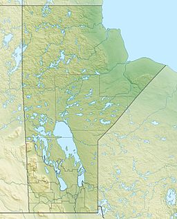
Lake Winnipegosis is a very large lake in central Manitoba, Canada. It covers about 5,370 square kilometers (2,073 square miles). This makes it Canada's eleventh-largest lake! You can find it about 300 kilometers (186 miles) northwest of the city of Winnipeg.
The name of the lake comes from Lake Winnipeg. "Winnipeg" means 'big muddy waters'. So, "Winnipegosis" means 'little muddy waters'. This name was first seen on a map in 1820, and the modern spelling has been used since at least 1811.
Contents
Exploring Lake Winnipegosis Geography

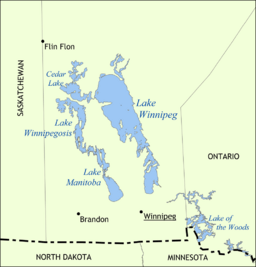
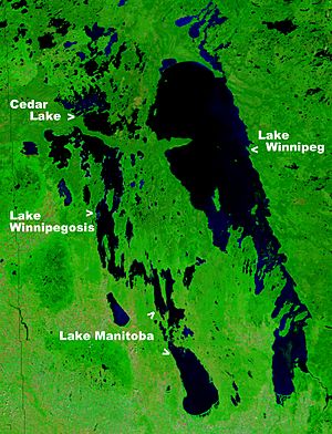
Lake Winnipegosis is a long lake, stretching 195 kilometers (121 miles). It is the second largest of three big lakes in central Manitoba. The other two are Lake Winnipeg (the biggest) and Lake Manitoba. All three of these lakes sit on what used to be the bottom of a huge ancient glacial lake called Lake Agassiz. Other nearby lakes, like Cedar Lake and the Lake of the Woods, are also part of this old lakebed.
The area of land that drains into Lake Winnipegosis, called its watershed, is huge. It covers about 49,825 square kilometers (19,237 square miles) across parts of Manitoba and Saskatchewan. Most of the water flowing into the lake comes from the Manitoba Escarpment.
Lake Winnipegosis is quite close to other lakes. It's separated from Cedar Lake by a narrow strip of land, only 6 kilometers (3.7 miles) wide, at its northern end. At its southeast end, it's separated from Lake Manitoba by an even narrower strip, just 3 kilometers (1.9 miles) wide, at a place called Meadow Portage.
Islands and Parks
The biggest island in Lake Winnipegosis is called Birch Island. It's located right in the middle of the lake. Birch Island is part of the Birch Island Provincial Park, which was created in 2010. Next to it, on the eastern shore, is the Chitek Lake Park Reserve.
How Water Flows Out
Lake Winnipegosis drains into Waterhen River. This river then flows into Lake Manitoba. This means Lake Winnipegosis is part of a larger water system that includes Lake Winnipeg, the Nelson River, and eventually leads to Hudson Bay.
From a part of the lake called Long Island Bay, at the southeast end, the West Waterhen and Little Waterhen rivers flow north for about 16 kilometers (10 miles) into Waterhen Lake. Then, the main Waterhen River flows south for 22 kilometers (13.5 miles) into Lake Manitoba.
Rivers Flowing In
Many rivers bring water into Lake Winnipegosis. Some of these include the Mossy River (which comes from Dauphin Lake), the Point River, Pine River, North Duck River, Pelican River (from Pelican Lake), Shoal River (from Swan Lake), Steeprock River, Red Deer River, and the Overflowing River.
Communities Around the Lake
Several communities are located around Lake Winnipegosis. South of Birch Island, you'll find Winnipegosis, Camperville, Pine Creek, Duck Bay, Salt Point, and Meadow Portage. To the north of the island are Shoal River, Pelican Rapids, Dawson Bay, and Denbeigh Point.
Fishing in Lake Winnipegosis
The lake is an important place for commercial fishing. Fishermen catch walleye and other types of freshwater fish here. Today, fish like Northern pike and mullet make up more than 80 percent of the fish caught for sale.
See also
 In Spanish: Lago Winnipegosis para niños
 | Emma Amos |
 | Edward Mitchell Bannister |
 | Larry D. Alexander |
 | Ernie Barnes |


