Manitoba Escarpment facts for kids
The Manitoba Escarpment is a long line of hills and slopes. It runs along the border between Saskatchewan and Manitoba. The eastern side of these hills is quite steep. This steep slope is called a scarp.
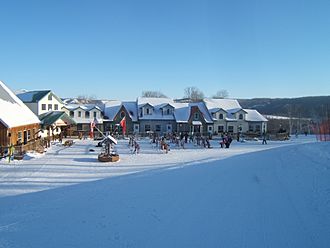
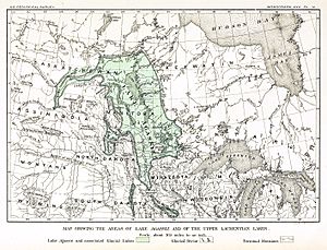
These hills were shaped by huge sheets of ice long ago. They also formed the western edge of a giant ancient lake called Lake Agassiz. Today, a popular place for winter fun, the Asessippi Ski Area, is found here.
Contents
A Look at History
Early People and Trade Routes
Before Europeans arrived, many different Indigenous groups lived in this area. These included the Swampy Cree, Plains Cree, Assiniboine, and Saulteaux tribes. The hills and valleys helped mark the boundaries of their lands. The river valleys also served as important trade routes for these groups.
The first European to explore this region was Henry Kelsey. He traveled with Cree traders from York Fort. His goal was to encourage the Indigenous people to trade with the Hudson's Bay Company.
Fur Trade and New Settlements
During the 1700s and 1800s, the fur trade brought many Europeans here. They set up trading posts and small communities. This trade was a big part of life in the region for a long time.
In the 1890s, the Canadian Northern Railway built a train line. It ran along the east side of the escarpment. This railway helped the forestry industry grow. Cutting down trees for wood became more important than trapping animals for fur.
Farming and New Canadians
Throughout the 1900s, more people came to live here. They started farms on both sides of the hills and in the river valleys. In Western Canada, it was common for settlers to live near people from their home country. This created "Block Settlements." Many settlers in this area were from Ukraine, Russia, or Poland.
Exploring the Geography
Surrounding Areas
To the east of the Manitoba Escarpment are the Manitoba Lowlands. This area has many connected lakes. These include Lake Winnipegosis, Dauphin Lake, and Lake Manitoba. The largest lake, Lake Winnipeg, is also here. All these lakes are what is left of the huge ancient Lake Agassiz.
To the north, you'll find the Saskatchewan River and its lowlands. This area was once covered by ancient Lake Saskatchewan. It might have been a bay connected to Lake Agassiz.
To the west, there used to be Aspen Parkland. This was a thin forest of trees that lose their leaves. Today, much of it has been cleared for farmland.
To the south are the Assiniboine and Souris River valleys. These areas were once covered by Lake Souris. This lake might also have been a bay of Lake Agassiz. South of this valley is the Pembina Escarpment. It also formed part of Lake Agassiz's shores.
The Four Hill Sections
Three rivers cut through the Manitoba Escarpment. These rivers divide the hills into four main sections:
- The Red Deer River separates the Pasquia Hills from the Porcupine Hills.
- The Swan River separates the Porcupine Hills from the Duck Mountains.
- The Valley River separates the Duck Mountains from the Riding Mountains.
How the Hills Were Formed (Geology)
The Manitoba Escarpment got its final shape after the last ice age. This was about 9,000 to 10,000 years ago. During the ice age, a huge ice sheet called the Laurentide Ice Sheet covered much of North America.
As this ice sheet melted, the water got trapped. It was stuck between the higher land to the west and the remaining ice to the east. This trapped water made the eastern slopes of the escarpment steeper. This is how it got its current shape. The hills like Pasquia, Porcupine, Duck, and Riding Mountains were already there. But the ice age made their eastern sides much steeper.
Plants and Animals (Ecology)
The forests on these hills are a mix of different trees. You'll mostly find aspen, poplar, spruce, and fir trees. There are also groups of white birch. Drier parts of the hills have jack pines. Wetter areas have tamarack trees.
Underneath the trees, there's a thick layer of shrubs and herbs. The forest floor is covered with mosses, ferns, and grass. Because these hills are somewhat isolated, you can find many rare plant species here. For example, the Hudson Bay, SK area has at least 6 rare types of violets and 21 rare kinds of orchids.
Asessippi Ski Area
Quick facts for kids Asessippi Ski Area & Resort |
|
|---|---|
 |
|

Asessippi's Winter Village
|
|
| Location | Rural Municipality of Riding Mountain West, |
| Nearest city | Inglis, Manitoba |
| Vertical | 121 m (397 ft) |
| Top elevation | 553 m (1,814 ft) |
| Base elevation | 432 m (1,417 ft) |
| Skiable area | 200 acres (0.8 km2) |
| Runs | 25 |
| Longest run | 0.7 km (0 mi) |
| Lift system | 1 Quad Chairlift, 2 Triple Chairlifts, 2 Handle Tows, 2 Magic Carpets |
| Terrain parks | 2 Terrain Parks |
| Snowfall | 2.5 m (8 ft) annually |
| Snowmaking | 100% |
| Website | Asessippi Ski Area & Resort |
The Asessippi Ski Area is the biggest ski resort in Manitoba. It is located right on the Manitoba Escarpment. It has a vertical drop of 122 meters (400 feet), which is the second largest in the province.
The resort is about 8 kilometers from Inglis, Manitoba. It's also 30 kilometers south of Roblin and 20 kilometers north of Russell. The ski area is built into the side of the Shell River Valley. It is also very close to Asessippi Provincial Park.
 | Aurelia Browder |
 | Nannie Helen Burroughs |
 | Michelle Alexander |


