Pembina Escarpment facts for kids

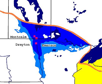
The Pembina Escarpment is a long, steep slope or cliff that stretches from South Dakota all the way to Manitoba, Canada. It forms the western edge of the wide, flat Red River Valley. This natural wall rises about 300 to 400 feet (91 to 122 meters) above the valley floor.
How the Pembina Escarpment Was Formed
The Pembina Escarpment has a long and interesting history. It was first shaped by an ancient version of the Red River. This river slowly cut into soft Cretaceous sandstone rocks. Later, huge sheets of ice, called glaciers, moved across the land. They scraped and carved the escarpment, making its slopes even steeper.
The escarpment stayed strong because of a tough layer of rock called shale (the Pierre Formation). This hard rock sits on top of the softer sandstone, protecting it from wearing away. Today, the area looks like a beautiful landscape of wooded hills with small farms nestled in valleys, such as the Pembina Valley. Streams flowing down the escarpment are fast and rocky.
The final shape of the Pembina Escarpment we see today was created at the end of the last ice age. This was about 12,000 years ago. During that time, a huge part of North America was covered by the Laurentide Ice Sheet. As this giant ice sheet began to melt, its water filled the ancient Red River Valley. This created a massive lake called Lake Agassiz.
The valley walls, including the Pembina Escarpment to the west, formed the eastern and western edges of this huge lake. The remaining part of the ice sheet made up the northern boundary. During this time, known as the Lockhart Phase of Lake Agassiz, water flowed south from the lake. It traveled into the Mississippi River and then all the way to the Gulf of Mexico.
Where the Pembina Escarpment Is Located
In the U.S., the Pembina Escarpment is considered a special natural area. It's called a Level 4 ecoregion by the U.S. Environmental Protection Agency. This ecoregion covers about 274 square miles (709 square kilometers). It is part of a larger area called the Northern Glaciated Plains ecoregion.
In Canada, the Pembina Escarpment is known as an Ecodistrict. It's part of the Southwest Manitoba Uplands Ecoregion, which itself is part of the Prairies Ecozone. Think of it like this: a Canadian Ecodistrict is similar to a U.S. Level 4 Ecoregion. A Canadian Ecoregion is like a U.S. Level 3 Ecoregion, and a Canadian Ecozone is like a U.S. Level 1 Ecoregion.
Both the U.S. and Canada see Turtle Mountain as a similar natural area to the Pembina Escarpment. This is because both countries place these two areas within the same larger ecoregions.
Some people in the U.S. might use the name "Manitoba Escarpment" for the Canadian part of the Pembina Escarpment. However, in Canada, the term Manitoba Escarpment refers to a different geographical area. That other escarpment is located along the border between Saskatchewan and Manitoba. The Pembina Escarpment is separated from the Manitoba Escarpment by the valleys of the Assiniboine and Souris Rivers. These valleys were covered by Lake Souris when Lake Agassiz was forming both escarpments.
Plants and Animals of the Pembina Escarpment
Before European settlers arrived in this region, the slopes and tops of the Pembina Escarpment were mostly covered by a deciduous forest. This forest was made up of trees like burr oak and trembling aspen. The parts of the slopes that were wetter, cooler, and shadier had more aspen trees. The drier, warmer, and sunnier slopes had more oak trees.
The smaller plants and bushes along the slopes included beaked hazel, high bush cranberry, saskatoon berry, and pin cherry.
Along rivers and creeks, where there was more moisture, you could find other trees. These included Manitoba maple, green ash, red osier dogwood, and different kinds of willows.
Today, much of the native plant life has been cleared away to make room for farming. However, you can still find these original plants on the steep slopes and near water sources. These are places where farming is difficult.
 | William Lucy |
 | Charles Hayes |
 | Cleveland Robinson |

