
Lake of Bays (Muskoka lake) facts for kids
Quick facts for kids Lake of Bays |
|
|---|---|

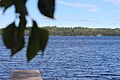
Pier at Dwight Beach
|
|

Lake of Bays
Location in Southern Ontario
|
|
| Location | District Municipality of Muskoka, Ontario |
| Coordinates | 45°15′02″N 78°59′54″W / 45.25056°N 78.99833°W |
| Primary inflows | Oxtongue River, Boyne River |
| Primary outflows | South Branch Muskoka River |
| Basin countries | Canada |
| Surface area | 70.53 km2 (27.23 sq mi) |
| Average depth | 22.25 m (73.0 ft) |
| Max. depth | 79.25 m (260.0 ft) |
| Water volume | 1,567,519,824 m3 (5.53564402×10¹⁰ cu ft) |
| Shore length1 | 170.59 km (106.00 mi) |
| Surface elevation | 315.47 m (1,035.0 ft) |
| Islands | Bigwin Island, Fairview Island, Langmaids Island, Roothog Island, Crown Island, Millichamp Island, Mariebianca Island, Champion Island, Castle Island, Burnt Island, Shamrock Island, Ensko Island, Hanes Island, Zephyr Island, Pancake Island, Turner's Island, Haystack Island, Raynor Island, Reuben Island, Harper Island, Rock Island, Gardner Island, Vimy Ridge Island, Wee Island, Helen Island |
| Settlements | Baysville, Dorset, Dwight |
| 1 Shore length is not a well-defined measure. | |
Lake of Bays is a very large lake located in the District Municipality of Muskoka in Ontario, Canada. It's mostly within the Township of Lake of Bays, which is named after the lake itself. A small part of the lake's southwest side is in the Town of Huntsville. You can find Ontario Highway 35 running along the north and east sides of the lake.
Several communities are found along the shores of Lake of Bays. These include Port Cunnington, Dwight, South Portage, Baysville, and Dorset.
Contents
Exploring Lake of Bays: Geography and Features
Rivers and Creeks Feeding the Lake
Lake of Bays gets its water from the Oxtongue River. Many other rivers and creeks also flow into it from the northeast. These include the Boyne River and its smaller branch, Sixteen Mile Creek. Other water sources are Ten Mile Creek, Hollow River, and St. Mary Creek.
Islands and Bays of the Lake
The largest island in Lake of Bays is Bigwin Island. Other islands you might spot include Burnt Island, Fairview Island, and Pancake Island. The lake has a very uneven shape with many different bays. Some of these are Rabbit's Bay, Dwight Bay, and Trading Bay.
The Story Behind the Name
How Lake of Bays Got Its Name
The First Nations people who lived here long ago had a very long name for the lake: Num g e low e nee g go mark lak a hagan. This means "Lake of Forks." It was also known by other names like Baptiste Lake and Forked Lake.
In 1837, an explorer named David Thompson traveled across the lake. He drew a map and called it Forked Lake. He even wrote about catching lake trout there! Later, an agent for the Hudson's Bay Company called it Trading Lake. Finally, in 1853, a survey by the Geological Survey of Canada officially named it Lake of Bays.
Fun Things to Do at Lake of Bays
Because Lake of Bays is so large and has many different sections, there are lots of fun things to do. You can find lodges, resorts, campgrounds, and golf clubs all around the lake. These places offer great ways to enjoy your time by the water.
Understanding Lake of Bays: Its Characteristics
Water Quality and Temperature
Lake of Bays is a deep and cold lake. It's an important part of the Muskoka watershed, which means it's part of a large system of connected waterways. The lake water is very clear. You can often see down about 8 meters (26 feet) into the water!
The top layer of the lake, about 9 meters (30 feet) deep, changes temperature throughout the year. In summer, this top layer can reach about 21°C (70°F). The very top few meters can even warm up to about 26.5°C (80°F). Below this warm top layer, the water quickly gets much colder, dropping to around 7°C (45°F).
Fish Species in Lake of Bays
Lake of Bays is home to many different kinds of fish. Some of the fish you might find here include:
- Lake trout
- Brook trout
- Rainbow trout
- Northern pike
- Pumpkinseed
- Rock bass
- Smallmouth bass
- Largemouth bass
- Cisco
- Whitefish
- White sucker
- Yellow perch
- Rainbow smelt
- Brown bullhead
- Fathead minnow
Fishing in Lake of Bays
Lake of Bays is a popular spot for fishing. People who own cottages, local residents, and many visitors all enjoy fishing here.
Popular Fish to Catch
Lake trout and smallmouth bass are the main types of fish that people try to catch for sport. The lake has even produced some very large lake trout, weighing over 20 pounds! These big trout can be tricky to catch and often require special equipment. Smallmouth bass are usually found in the shallower water near the shore or on rocky areas.
Winter Fishing
Even in the winter, when the lake freezes over, you can still go fishing! During this time, people often catch lake trout, whitefish, and burbot.
Images for kids
-
A peaceful dock on Lake of Bays.

