Lambrigg Fell facts for kids
Quick facts for kids Lambrigg Fell |
|
|---|---|

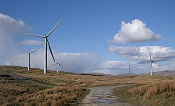
The Lambrigg wind farm, looking north
|
|
| Highest point | |
| Elevation | 339 m (1,112 ft) |
| Prominence | c. 152 m |
| Parent peak | Grayrigg Forest |
| Listing | Marilyn |
| Geography | |
| OS grid | SD586941 |
| Topo map | OS Landranger 97 |
Lambrigg Fell is a hill in south-eastern Cumbria, England. It's the highest point in the area between the town of Kendal and the M6.
Even though it's close to the famous Lake District, Lambrigg Fell looks a bit different. It's a wide, grassy moorland rather than the rocky peaks you might expect. But don't let that fool you! From the top, you can see amazing views of the Howgill Fells, parts of the Lake District, and even the Yorkshire Dales.
Contents
Exploring Lambrigg Fell
Lambrigg Fell is not as busy as some other hills nearby. This is because it's a sprawling, grassy area, unlike the more popular rocky fells of the Lake District.
Getting to the Top
You can reach the hill using a small road that connects Docker and Lambrigg Head. This road goes across the northern side of the fell.
There is a track that leads most of the way to the top. It passes a small reservoir on the way. The full walk to the summit is about two and a half miles long.
Old Building Ruins
About 100 meters west of the summit, you can find the ruins of a small building. People who live nearby say it was once a shelter. It was likely used by people taking part in shooting parties on the fell.
The Wind Farm
There is a large wind farm located just east of the summit of Lambrigg Fell. This wind farm is owned by a company called Innogy.
The wind farm started operating in September 2000. At that time, it was the biggest wind farm built in England since 1993. It can create enough electricity to power many homes. The area where the wind farm is built is not open to the public without permission.
What is a Marilyn?
Lambrigg Fell is known as a "Marilyn." A Marilyn is a hill or mountain in the British Isles. It must have a height of at least 150 meters (about 492 feet) above the surrounding land.
Lambrigg Fell is the highest point in its block of land. This area is in the very south-east of the Lakeland region. It lies between the River Kent and the River Lune. Other Marilyns in this area include Hutton Roof Crags and Arnside Knott.
 | Dorothy Vaughan |
 | Charles Henry Turner |
 | Hildrus Poindexter |
 | Henry Cecil McBay |

