
Landers, California facts for kids
Quick facts for kids
Landers
|
|
|---|---|

The Landers sign outside the U.S. Post Office on Reche Road at Landers Lane
|
|

Landers
Location in California
|
|
| Country | United States |
| State | California |
| County | San Bernardino |
| Elevation | 3,084 ft (940 m) |
| Population | |
| • Census Designated Place estimated 2017 | 2,982 |
| Demonym(s) | Landroid |
| Time zone | UTC-8 (Pacific) |
| • Summer (DST) | UTC-7 (PDT) |
| ZIP codes |
92285
|
| Area codes | 442/760 |
| FIPS code | 06-40158 |
| GNIS feature ID | 244564 |
Landers is a small community in the Mojave Desert in San Bernardino County, California. It's not a city, but an unincorporated community, meaning it doesn't have its own local government. In 2017, about 2,982 people lived there.
People who live in Landers are sometimes called "Landroids." This fun nickname comes from the area's interest in UFOs. Landers' official slogan is "Beautiful Skies, Miles of Smiles." This slogan was chosen in 2014 after a contest. It was suggested by a class of 3rd and 4th graders at Landers Elementary School! For many years, locals also called Landers "the land of 1000 vistas" because of its wide-open views.
Contents
Landers History
The Landers area was first settled in the early 1900s. Gold miners came here looking for gold in a place called Goat Mountain. Charles Reche was one of the first to arrive in 1914.
From the late 1940s to the 1970s, Landers became a popular spot for people interested in UFOs. Two main attractions for these visitors were the Integratron and the nearby Giant Rock.
On June 28, 1992, Landers was the center of a very strong earthquake. This earthquake had a magnitude of 7.4 and caused a lot of damage to buildings in the area.
Today, the Morongo Basin Historical Society is located in Landers. You can find it in the building that used to be the original Post Office.
Landers Geography

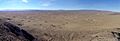
Landers is located in the Homestead Valley, which is part of the southeastern Mojave Desert. The community is about 3,100 feet (940 meters) above sea level. The highest point nearby is Goat Mountain, which rises 625 feet above the surrounding land.
Landers is about 14 miles (23 km) north of Yucca Valley. It shares a border with Flamingo Heights to the south. To the southeast, you'll find the city of Joshua Tree. Johnson Valley, California is located north of Landers. Pioneertown is to the southwest. A road called California State Route 247, also known as "Old Woman Springs Road," goes through Landers. It connects Yucca Valley to Barstow in the north.
The Marine Corps Air Ground Combat Center (MCAGCC), often called 29 Palms, borders Landers to the north and east.
Giant Rock Landmark

Right next to Landers, to the north, is Giant Rock. This huge rock covers about 5,800 square feet and is as tall as a seven-story building! Many believe it's the largest freestanding boulder in the world. In February 2000, a large part of its southern side broke off.
Giant Rock was a sacred place for the Native American tribes in the region. Northern and southern tribes would meet there every year. You can still see the remains of an old dirt airstrip nearby. This airstrip was used from 1947 to 1975. There's also a concrete pad where a cafe once stood. This cafe was built by George Van Tassel, who also built the Integratron.
Landers Economy
The U.S. Landers Post Office is located at Landers Lane and Reche Road. It serves the area's ZIP code, which is 92285. Landers also has a community center called Belfield Hall, a convenience store, and an elementary school. There's also a recreational center with a lighted ball field. The Landers Brew Co. is in an old roadhouse that was built in 1948.
In the past, Landers had its own airport, and another one was near Giant Rock. Both had short, dirt runways for small planes. However, neither of these airports is used today.
Astronomical Facilities in Landers
Landers is home to two important places for amateur astronomy:
- The Goat Mountain Astronomical Research Station (GMARS): This facility is owned by the Riverside Astronomical Society. It's one of the most impressive setups of its kind in the world. It has over 23 observatories and a seismic station powered by solar energy. It also has more than twenty spots with electricity where people can set up their telescopes. GMARS is used for scientific activities and has an international observatory code of G79.
- The Center for Solar System Studies (CS3): This center has nine robotic observatories. It mainly focuses on studying asteroids and measuring their brightness. The observatory codes assigned at CS3 are U80, U81, and U82.
The Integratron

An author, inventor, and UFO supporter named George Van Tassel (1910–1978) built the Integratron structure. He worked on it in the Giant Rock area from 1957 to 1977. The Integratron has a unique dome shape made of wood. It has 16 strong, curved wooden beams that meet at the top, held together by a ton of concrete. The building is 38 feet (12 meters) high and 50 feet (15 meters) across.
The Integratron and Giant Rock are the two most interesting places in Landers for people who are curious about UFOs. Famous food and travel TV host Anthony Bourdain even featured Van Tassel and the Integratron in his show No Reservations in 2011. In 2018, a filmmaker named Jonathan Berman made a documentary called Calling All Earthlings about Van Tassel, the Integratron, and Giant Rock.
Today, the Integratron is open to the public. It's used for studies, performances, and retreats. People come here for programs about sound, music, meditation, energy healing, architecture, health, science, and spirituality.
Images for kids
-
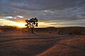
The Landers desert landscape is home to the protected Joshua Tree
-
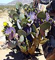
Opuntia basilaris, or Beavertail Cactus, is common in Landers
-
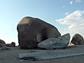
Giant Rock, adjacent to Landers, California
-
View to the NE of Goat Mountain in Landers, California, with the Goat Mountain Astronomical Research Station in foreground
-

There is an annual fireworks event in Landers, California, held at its recreational park and ball field
-
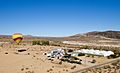
In 2016, the Orchid Festival at Gubler Orchids featured hot air balloon rides
-
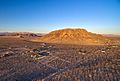
Aerial view of the community of Landers taken from over its highest point Goat Mountain
-
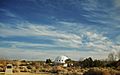
View of the Integratron and the surrounding landscape, winter 2018
-

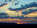
Midsummer twilight over the Mojave desert in Landers
-
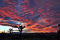
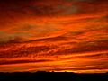
Red sunset twilight, Landers, California USA
-
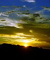
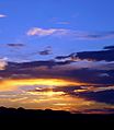
Burning Yellow Sunset, Landers, California USA
-
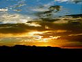
Mustard Blue Sunset, Landers, California USA
-
Burnt Horizon, Landers, California
-
Fire Twilight, Landers, California
-
Royal Blue Sky over Horizon, Landers, California


