Leaden Roding facts for kids
Quick facts for kids Leaden Roding |
|
|---|---|
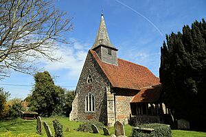
 St Michael's Church, Leaden Roding |
|
| OS grid reference | TL594133 |
| Civil parish |
|
| District |
|
| Shire county | |
| Region | |
| Country | England |
| Sovereign state | United Kingdom |
| Post town | Dunmow |
| Postcode district | CM6 |
| Dialling code | 01279 |
| Police | Essex |
| Fire | Essex |
| Ambulance | East of England |
| EU Parliament | East of England |
| UK Parliament |
|
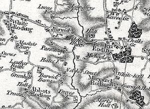
Leaden Roding is a small village in Essex, England. It's part of a group of eight villages and hamlets known as The Rodings. Leaden Roding is about 8 miles (13 km) northwest of Chelmsford, a larger town in Essex.
Contents
History of Leaden Roding
Village Name and Early Days
The name "Roding" comes from "Rodinges," which was written in the famous Domesday Book. This book was a huge survey of England ordered by William the Conqueror in 1085. Later, in 1248, the village was called 'Ledeineroing'. The "Leaden" part of the name probably refers to the lead roof of the local church.
Even though Leaden Roding isn't directly in the Domesday survey, its land was once taken by William the Conqueror. He gave this land to Geoffrey de Mandeville. Later, it was passed to William de Warenne, 1st Earl of Surrey.
Church and Land Ownership
The church in Leaden Roding, called Leaden-Church, was given by William de Warenne to Castle Acre Priory, a monastery he started in Norfolk in 1090. This monastery owned the church until the Dissolution of the Monasteries in the 1500s.
After that, the church's ownership changed hands many times. It went to important families like the Bourchiers and the Parrs. Later, the Luther family owned it until at least 1738. Other parts of Leaden Roding's land were given by King Henry VIII to his friend Charles Brandon, 1st Duke of Suffolk.
Manor and Local Government
During the 1200s, the manor (a large estate) of Leaden Roding was held by Hugh Blount. In the 1300s, it was owned by John Doreward. Over the years, the manor was passed to different families, including the Waldgraves and the Sherecrofts.
Leaden Roding was part of the Dunmow Hundred, which was an old way of dividing land. From the 1830s, it was also part of the Dunmow Union. This union helped provide support for poor people under the Poor Law Amendment Act 1834.
Lords and Rectors
In 1848, the main landowner, or lord of the manor, was Henry Trevor, Lord Dacre. Later, Captain James Odams held this role. The church's rectory (the church's main priest) had its own house and land. This land was called glebe and was used to support the priest. The right to choose the rector was held by important people like the Lord Chancellor.
The local church, St Michaels and All Saints, was repaired in 1866. Its records for baptisms and burials go all the way back to 1572. In the 1880s, there was also a Congregational chapel in the village.
Schools in the Village
By 1848, children from Leaden Roding could go to D'Oyley's School in Margaret Roding. In 1882, Leaden Roding had its own Mixed School with about 18 students. Later, it became a National School for boys and girls. By 1914, it was a Public Elementary School run by Essex Education.
Village Life and Jobs
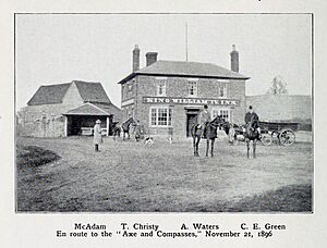
In 1848, Leaden Roding covered about 873 acres (3.5 sq km). Farmers mainly grew wheat, barley, and beans. The village had a few important jobs. There were farmers, a wheelwright (who made and repaired wheels), a butcher, and a shopkeeper. The King William IV public house (a pub) was also a key part of the village. It opened in the early 1800s and was a central meeting place until it closed in the 1990s.
Over the years, other jobs appeared in the village. These included a shoemaker, carpenter, thatcher, gardener, bricklayer, and a grocer and draper. By 1894, the Post Office sub-postmaster was also the grocer and draper. In 1914, the village had a police station with a constable. There was also a "carrier" who transported goods and people to Chelmsford on certain days.
Leaden Roding was also known as a place for fox hunting. In 1896, a book called The Essex Foxhounds mentioned Leaden Roding and the King William IV Inn as important spots for hunting in the area.
Community Life
Leaden Roding is part of the Saffron Walden area for national elections. It's also part of the High Easter & the Rodings ward for the local Uttlesford District Council. The village has its own parish council that helps manage local matters. Leaden Roding is one of The Hundred Parishes, a special group of villages in the East of England known for their unique history.
Today, Leaden Roding has a village hall, a cricket club, and a fire and rescue station. There's also a village store and a company that offers garage services. The local school for children is Rodings Primary School.
See also
 In Spanish: Leaden Roding para niños
 | William L. Dawson |
 | W. E. B. Du Bois |
 | Harry Belafonte |


