Linby facts for kids
Quick facts for kids Linby |
|
|---|---|
| Village and civil parish | |
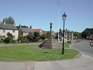
 Top Cross, Linby |
|
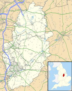
Parish map |
|
| Area | 1.43 sq mi (3.7 km2) |
| Population | 676 (2021) |
| • Density | 473/sq mi (183/km2) |
| OS grid reference | SK 535510 |
| • London | 115 mi (185 km) SSE |
| District |
|
| Shire county | |
| Region | |
| Country | England |
| Sovereign state | United Kingdom |
| Post town | NOTTINGHAM |
| Postcode district | NG15 |
| Dialling code | 0115 |
| Police | Nottinghamshire |
| Fire | Nottinghamshire |
| Ambulance | East Midlands |
| EU Parliament | East Midlands |
| UK Parliament |
|
| Website | https://linby.org.uk |
Linby is a small village in Nottinghamshire, England. It is also a civil parish, which is a local area with its own council. The nearest town is Hucknall, which is just to the south-west. Linby's name comes from the River Leen, which flows nearby. The village grew up around mills that used the river's power. Small streams called Linby Docks run on both sides of the main street. In 2021, about 676 people lived in Linby.
Contents
Linby's Past
Linby is a village with a long history. In the 1870s, a writer named John Marius Wilson described Linby as a village near the Nottingham and Mansfield railway. He mentioned its railway station and post office. Linby was also known for two old crosses. People thought these crosses marked the edge of Sherwood Forest.
Old Buildings and Crosses
The local church in Linby is called St. Michael's Church. It is a very old building, with parts dating back to the 1200s! The church has been made bigger and fixed up many times over the years. It is now a special building, known as a Grade II* listed building.
There are two old crosses in the village. The "Top Cross" was built in the 1300s and was repaired in the late 1800s. It is also a Grade II listed building. The "Bottom Cross" has the year 1663 carved into it. Some people think it was put there to celebrate King Charles II becoming king again.
In 2013, Linby won an award for being Nottinghamshire's "best kept village."
How Linby is Managed
Linby has been part of different local government areas over time. From 1894 to 1974, it was part of Basford Rural District. After that, it became part of Gedling Borough. A small part of Linby parish was moved to Hucknall in 1935.
Linby is also part of an area in Nottinghamshire called the Hidden Valleys.
Getting Around Linby
The Linby Trail is a path that is 2 kilometres (about 1.2 miles) long. It starts in the village and ends at Newstead Village. This trail is part of the National Cycle Route, which is a network of paths for bikes.
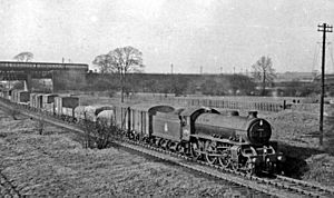
Three railway lines used to pass through Linby. Two of these lines even had stations in the village.
One line was the Midland Railway line, which went from Nottingham to Mansfield and Worksop. This line stopped carrying passengers in 1964. However, parts of it were still used for carrying goods, especially for coal mines. In the 1990s, this line was reopened for passengers, but the Linby station did not reopen.
Another line was the Great Northern Railway route. It went to many of the same places as the Midland line. This line stopped carrying passengers in 1931 and stopped carrying goods in 1968. The Linby station on this line closed even earlier, in 1916.
The third line was the Great Central Railway. This was the last main railway line ever built from the north of England to London. It opened in 1899. The part of this line that went through Linby closed completely in 1966. This line crossed over the other two lines, but there was never a station in Linby on this railway.
Sports in Linby
The village has its own football team, called Linby Colliery F.C..
 | Janet Taylor Pickett |
 | Synthia Saint James |
 | Howardena Pindell |
 | Faith Ringgold |


