Lincoln County, Georgia facts for kids
Quick facts for kids
Lincoln County
|
|
|---|---|

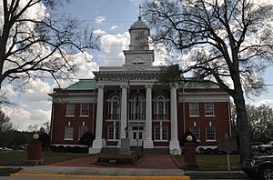
Lincoln County Courthouse in Lincolnton
|
|

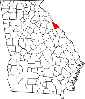
Location within the U.S. state of Georgia
|
|
 Georgia's location within the U.S. |
|
| Country | |
| State | |
| Founded | February 20, 1796 |
| Named for | Benjamin Lincoln |
| Seat | Lincolnton |
| Largest city | Lincolnton |
| Area | |
| • Total | 257 sq mi (670 km2) |
| • Land | 210 sq mi (500 km2) |
| • Water | 47 sq mi (120 km2) 18.2%% |
| Population
(2020)
|
|
| • Total | 7,690 |
| • Estimate
(2023)
|
7,879 |
| • Density | 29.92/sq mi (11.553/km2) |
| Time zone | UTC−5 (Eastern) |
| • Summer (DST) | UTC−4 (EDT) |
| Congressional district | 10th |
Lincoln County is a county in the east central part of Georgia. A county is like a smaller region within a state. It helps organize local government and services.
As of 2020, about 7,690 people live here. The main town, or county seat, is Lincolnton. Lincoln County was created a long time ago, on February 20, 1796. It is part of the larger Augusta area. The Savannah River forms its northeastern border.
Contents
History of Lincoln County
Lincoln County became Georgia's 24th county on February 20, 1796. Before this, it was part of Wilkes County.
The county was named after General Benjamin Lincoln (1733-1810). He was a hero in the American Revolutionary War. He is famous for accepting General Cornwallis's surrender at Yorktown, Virginia. This was a very important moment in American history.
In 1852, the border between Wilkes County and Lincoln County was changed. We don't know exactly why this change happened.
For many years, until the 1950s, Lincoln County was mostly a farming area. Then, the Clarks Hill Dam was built. This created a huge lake that covered parts of Lincoln County. Many new neighborhoods have been built near this lake.
Geography of Lincoln County
Lincoln County covers about 257 square miles. About 210 square miles are land, and 47 square miles are water. This means about 18% of the county is water.
The county is located in the Piedmont region of Georgia. This area is known for its rolling hills. Most of Lincoln County is in the Upper Savannah River area. A small northern part is in the Broad River area. The southern part is in the Little River area. All these rivers flow into the larger Savannah River.
Main Roads in Lincoln County
 U.S. Route 378
 State Route 43
 State Route 43 Connector
 State Route 44
 State Route 47
 State Route 79
 State Route 220
Neighboring Counties
- Elbert County, Georgia - to the north
- McCormick County, South Carolina - to the northeast
- Columbia County, Georgia - to the south
- McDuffie County, Georgia - to the southwest
- Wilkes County, Georgia - to the west
Towns and Communities
City
Unincorporated Community
People of Lincoln County (Demographics)
Demographics is the study of populations. It looks at things like how many people live somewhere and what groups they belong to.
| Historical population | |||
|---|---|---|---|
| Census | Pop. | %± | |
| 1800 | 4,766 | — | |
| 1810 | 4,555 | −4.4% | |
| 1820 | 6,458 | 41.8% | |
| 1830 | 6,145 | −4.8% | |
| 1840 | 5,895 | −4.1% | |
| 1850 | 5,998 | 1.7% | |
| 1860 | 5,466 | −8.9% | |
| 1870 | 5,413 | −1.0% | |
| 1880 | 6,412 | 18.5% | |
| 1890 | 6,146 | −4.1% | |
| 1900 | 7,156 | 16.4% | |
| 1910 | 8,714 | 21.8% | |
| 1920 | 9,739 | 11.8% | |
| 1930 | 7,847 | −19.4% | |
| 1940 | 7,042 | −10.3% | |
| 1950 | 6,462 | −8.2% | |
| 1960 | 5,906 | −8.6% | |
| 1970 | 5,895 | −0.2% | |
| 1980 | 6,716 | 13.9% | |
| 1990 | 7,442 | 10.8% | |
| 2000 | 8,348 | 12.2% | |
| 2010 | 7,996 | −4.2% | |
| 2020 | 7,690 | −3.8% | |
| 2023 (est.) | 7,879 | −1.5% | |
| U.S. Decennial Census 1790-1880 1890-1910 1920-1930 1930-1940 1940-1950 1960-1980 1980-2000 2010 |
|||
| Race | Number of People | Percentage |
|---|---|---|
| White | 5,196 | 67.57% |
| Black or African American | 2,116 | 27.52% |
| Native American | 18 | 0.23% |
| Asian | 20 | 0.26% |
| Pacific Islander | 3 | 0.04% |
| Other/Mixed | 245 | 3.19% |
| Hispanic or Latino | 92 | 1.2% |
In 2020, there were 7,690 people living in Lincoln County. These people lived in 3,475 households, and 2,142 of these were families.
Fun Things to Do and Historic Places
The creation of Clarks Hill Lake has made Lincoln County a great place for fun activities. Many tourists visit for fishing, boating, and other water sports. It's a popular spot for both visitors and people who live nearby.
On the eastern side of Lincoln County, close to South Carolina, you'll find Elijah Clarke State Park. This park is quite large, covering about 447 acres. Every May, the park hosts a bluegrass festival. This event has become very popular over the last 20 years. Famous bluegrass musicians, including local group The Lewis Family, often play there. The park also holds an Arts and Crafts Festival and a Log Cabin Christmas event each year.
Lincoln County has many interesting historic places to explore:
- Lamar-Blanchard House in Lincolnton, which is listed on the National Register of Historic Places.
- The Lincoln County Historical Park.
- Graves Mountain.
Economy of Lincoln County
The economy of Lincoln County has grown a lot because of the J. Strom Thurmond Dam and Clarks Hill Lake.
Logging is a very important industry here, bringing in millions of dollars. Over 20 logging businesses provide many jobs for the people of Lincoln County. The county is also home to Back Paddle Brewing, a craft brewery owned by a veteran.
Famous People from Lincoln County
- Garrison Hearst - A former NFL football player. He was a "pro bowler" and won "comeback player" awards in 1995 and 2001.
- Barney Bussey - Another former NFL football player. He played for the Cincinnati Bengals and the Tampa Bay Buccaneers.
- The Lewis Family - A family band known for bluegrass and gospel music. They were added to the Georgia Music Hall of Fame in 1992.
- Tom Nash - An NFL player who played for the Green Bay Packers and the Brooklyn Dodgers.
See also
 In Spanish: Condado de Lincoln (Georgia) para niños
 | Kyle Baker |
 | Joseph Yoakum |
 | Laura Wheeler Waring |
 | Henry Ossawa Tanner |

