Lincoln Highway Hackensack River Bridge facts for kids
Quick facts for kids Lincoln Highway Bridge |
|
|---|---|
 |
|
| Coordinates | 40°43′38″N 74°5′56″W / 40.72722°N 74.09889°W |
| Carries | Lincoln Highway East Coast Greenway |
| Crosses | Hackensack River |
| Locale | Jersey City and Kearny |
| Other name(s) | Shawn Carson and Robert Nguyen Memorial Bridge Route 1&9 Lincoln Highway Bridge Rte 1&9 Hackensack River Bridge |
| Owner | New Jersey Department of Transportation |
| Characteristics | |
| Design | Vertical lift |
| Material | Steel |
| Total length | 1,480.1 feet (451.1 m) |
| Width | 73.5 feet (22.4 m) |
| Height | 75 feet (23 m) |
| Longest span | 222.1 feet (67.7 m) |
| Clearance above | 16.2 feet (4.9 m) |
| Clearance below | 35 feet (11 m) (mean high water) 40 feet (12 m) (mean low water) |
| History | |
| Construction begin | 1951 |
| Construction end | 1954 |
| Lua error in Module:Location_map at line 420: attempt to index field 'wikibase' (a nil value). | |
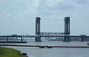
The Lincoln Highway Hackensack River Bridge is a special kind of bridge called a vertical lift bridge. It crosses the Hackensack River in Hudson County, New Jersey, United States. This bridge is part of the historic Lincoln Highway route. It carries U.S. Route 1/9 Truck and the East Coast Greenway. The bridge connects the West Side of Jersey City with Kearny Point in Kearny.
The bridge we see today was finished in 1954. It is owned and managed by the New Jersey Department of Transportation (NJDOT). Because it crosses a river used by boats, it must open when ships need to pass. In 2007, the bridge was given a special name: the Shawn Carson and Robert Nguyen Memorial Bridge.
Contents
Where is the Bridge Located?
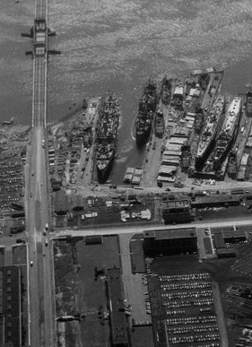
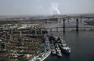
The Lincoln Highway Bridge crosses the Hackensack River in an area known for its waterways. On the east side of the river, you'll find places like Hudson Mall and Lincoln Park. The west side, called Kearny Point, is a busy area with many factories and warehouses. In the past, it was home to large shipbuilding companies.
This bridge is very important for moving goods in the Port of New York and New Jersey. Trucks use it to reach many shipping and transport centers in the New Jersey Meadowlands. It also helps them get to the Holland Tunnel, which goes to New York City. Another important bridge, the Lincoln Highway Passaic River Bridge, crosses the nearby Passaic River to connect to Port Newark and Newark Airport. Trucks often use this route because the nearby Pulaski Skyway does not allow them.
Early Roads and River Crossings
Long ago, in 1765, people in New Jersey wanted to build a new road. This road would connect the city of Newark to Paulus Hook (now Exchange Place) in Jersey City. It followed existing paths and crossed the Hackensack River. Before bridges were built, people used ferries to cross the rivers. These ferries were operated by a man named Brown, so the crossing was known as Brown's Ferry.
In the early 1800s, the Morris Canal was built. Its path also crossed the rivers near where the bridges are today.
A History of Bridges: From Wood to Steel
In 1849, a company was given permission to improve and operate the road. It became known as the Newark Plank Road. Soon after, this company wanted to build bridges over the Hackensack and Passaic rivers. Another company that already had bridges protested this idea.
Despite the protests, a bridge was built across the Hackensack River by 1856. This early bridge was made of wood and could swing open to let boats pass.
Later, in 1895, streetcar service began along the plank road. A new bridge was built in 1906 to support this growing traffic.
The Lincoln Highway Era
Around the early 1900s, there was a movement to create better roads across the country. This led to the creation of the Lincoln Highway, the first highway to stretch across the entire United States. New Jersey spent a lot of money to widen and repave its part of the highway, including the bridges. On December 13, 1913, the new "Lincoln Way" was officially opened.
By the 1920s, this part of the Lincoln Highway was one of the busiest roads in the country. Surveys showed thousands of vehicles crossing the river every day.
Bridge Collisions and Failures
The bridges at this location faced many challenges. On June 22, 1922, a large steamship called the Glenaruel crashed into the bridge. The ship hit the bridge span, which had opened for it, and the iron structure collapsed. It was too damaged to fix.
A new double leaf bascule bridge was built in 1927 to replace the destroyed one. However, this bridge also had problems. Just over a year later, on December 15, 1928, part of the bridge fell into the river. Engineers later found that the bridge's design was not strong enough to handle the stress of opening and closing. This caused the metal to weaken over time.
How the Current Bridge Works
Construction of the current vertical lift bridge began in 1951. It cost about $8 million to build and opened in June 1954. The governor of New Jersey, Robert B. Meyner, was there for the opening ceremony.
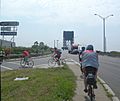
This bridge is made of strong steel and concrete. It is about 1,480.1 feet (451.1 m) long, 73.5 feet (22.4 m) wide, and 75 feet (23 m) tall. It has six lanes for vehicles on U.S. Route 1/9 Truck and also carries the East Coast Greenway, a path for bikes and walkers. The bridge was updated in 2003, and more repairs were done between 2009 and 2011.
The middle part of the bridge, called the lift span, is 222.1 feet (67.7 m) long. It moves straight up and down between two tall steel towers. Engines and heavy counterweights help raise and lower this section. This design reminds people of America's industrial past.
The Hackensack River is still used by some commercial boats, like those delivering coal. Because of this, the bridge's lift span must be raised whenever a boat needs to pass. In 1936, the old bridge used to open up to 48 times a day! In 2005, the current bridge opened about 20 to 30 times each month. By 2014, it was opening around 1000 times a year.
Images for kids
 | Ernest Everett Just |
 | Mary Jackson |
 | Emmett Chappelle |
 | Marie Maynard Daly |


