
List of local nature reserves in Essex facts for kids
Essex is a county in the east of England, a country that is part of the United Kingdom. It borders other counties like Suffolk, Cambridgeshire, Hertfordshire, and Greater London. To the south, it's separated from Kent by the River Thames, and to the east, it meets the North Sea. Essex covers about 3,670 square kilometers (1,420 square miles) and has a long coastline of about 640 kilometers (400 miles). In 2011, about 1.4 million people lived there.
Local Nature Reserves (LNRs) are special places in Essex. Local councils choose these areas because they are important for nature, either for their plants and animals or their geology. The council must have control over the land, like owning it or having an agreement with the owner. LNRs are protected, and local rules help manage them.
As of 2016, Essex has 49 Local Nature Reserves. Some of these are also recognized as Sites of Special Scientific Interest (SSSI), which means they are nationally important for wildlife or geology. A few are even Scheduled Monuments (SM), protecting historical sites. Four of these reserves are looked after by the Essex Wildlife Trust. The biggest LNR is Southend-on-Sea Foreshore, covering a huge 1,084 hectares (2,679 acres). It's a very important spot for birds that migrate. The smallest is Nazeing Triangle, which is only 0.5 hectares (1.2 acres) and features a small pond and wildflower meadows.
Understanding the Symbols
Here are some symbols you'll see in the list of nature reserves:
Access for Visitors
- FP = You can only walk on footpaths through the site.
- NO = No public access allowed.
- PP = You can visit some parts of the site for free.
- Yes = You can freely visit most or all of the site.
Other Special Classifications
- EWT = Managed by the Essex Wildlife Trust.
- Ramsar = A wetland site of international importance.
- SPA = A special area protected for birds.
- SM = A Scheduled monument, protecting historical or archaeological sites.
- SSSI = A Site of Special Scientific Interest, important for its wildlife or geology.
Local Nature Reserves in Essex
| Top - 0-9 A B C D E F G H I J K L M N O P Q R S T U V W X Y Z |
| Site Name | Area (hectares) | Location | Public Access | Special Classifications | What Makes It Special |
|---|---|---|---|---|---|
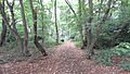
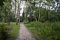
| Belfairs | 37.1 | Leigh-on-Sea | Yes | EWT, SSSI | This ancient woodland is one of the largest old forests in south Essex. It has oak trees and plants like bramble and honeysuckle. You might even find the rare broad-leaved helleborine flower here. |
| Belton Hills | 22.0 | Leigh-on-Sea | Yes | This area has steep slopes with lots of scrub. It's home to some rare plants and many different insects. Over 600 types of invertebrates were found here in 2001. | |
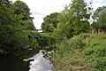
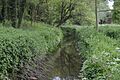
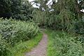
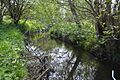
| Bocking Blackwater | 13.1 | Braintree | Yes | This long, narrow strip of land follows the River Blackwater. It has many different types of plants, including very old trees. You'll find wetlands, woodlands, and wildflower meadows here. | |
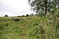
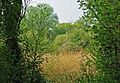
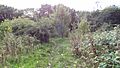
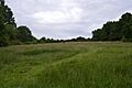
| Brickfield and Long Meadow | 3.9 | Earls Colne | Yes | This meadow is very important for plants and insects. It has hundreds of yellow ant hills and many kinds of butterflies. Common flowers include yarrow and ox-eye daisy. | |
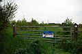
| Brockwell Meadows | 4.3 | Kelvedon | Yes | This site features water meadows, woodlands, a pond, and hedgerows. The River Blackwater flows along its eastern side. | |
| Bull Meadow | 1.4 | Colchester | Yes | This damp grassland is next to the River Colne. It has plants like purple loosestrife and stinging nettles. Many butterflies, spiders, and warbler birds live here. | |
| Canvey Lake | 8.3 | Canvey Island | Yes | This lake used to be a creek, now changed by a sea wall. It's home to mallards, moorhens, and water voles. They've also created a shingle bank and cut back reed beds to help wildlife. | |
| Chelmer Valley Riverside | 17.6 | Chelmsford | Yes | This reserve stretches along the River Chelmer. It has grasslands, old hedges, scrub, and woodlands. The southern part is more managed, with mown grass and marshland. | |
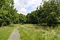
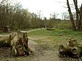
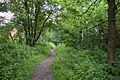
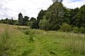
| Chigwell Row Wood | 14.1 | Chigwell | Yes | This wood is a small part of the ancient Hainault Forest. It has many old trees, some over 250 years old, mostly hornbeam and oak. Over 800 types of insects have been found here. | |
| Church Lane Flood Meadow | 3.3 | North Weald Bassett | FP | This site was designed to help with flooding and is managed for wildlife. It has a pond, wet grassland, and over 2,500 native trees. You can find ragged robin flowers, butterflies, dragonflies, and many birds. | |
| Colne | 34.7 | Wivenhoe | Yes | This reserve has different habitats, including Wivenhoe Marsh next to the River Colne, and Wivenhoe Woods with many tree species. | |
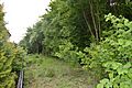
| Colne Valley | 5.1 | Earls Colne | Yes | This long strip of land used to be a railway line. Now it's wildflower meadows, home to otters, bats, stag beetles, and various birds. | |
| Cuckoo Wood | 2.5 | Braintree | NO | This site has grasslands, meadows, woods, lakes, and ponds. It's a great place for fungi because of all the dead wood. | |
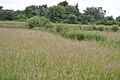
| Fenn Washland | 4.9 | South Woodham Ferrers | Yes | This undeveloped wetland is in a valley surrounded by houses. It has grassland, swamps, ponds, and reedbeds, offering many homes for wildlife. | |
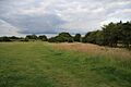
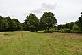
| Galleywood Common | 44.6 | Chelmsford | Yes | Galleywood Common has been around since the Domesday Book was written! It has many different habitats like heathland, woodlands, grasslands, and ponds, supporting a wide variety of animals. | |
| Gosfield Sandpits | 8.3 | Braintree | Yes | This area used to be sandpits and now has about a mile of footpaths, woodlands, and many ponds. You'll find a wide range of trees and flowers like wood anemones and bluebells. | |
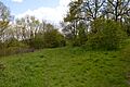
| Grove House Wood | 2.2 | Stanford-le-Hope | Yes | This wood has dead elm trees that are perfect nesting spots for woodpeckers. It also has a pond, a brook, and reedbeds. | |
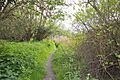
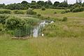
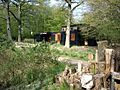
| Harlow Marsh | 13.8 | Harlow | Yes | SM | This site is split into three areas. One part, Parndon Moat Marsh, has an old moat that is a protected historical site, plus wildflower meadows and woodlands. |
| Hawkenbury Meadow | 1.6 | Harlow | Yes | This meadow has a brook running through it and many wild flowers like yellow rattle and common spotted orchids. There are also mature woodlands and marshland plants. | |
| Hilly Fields | 37.5 | Colchester | Yes | SM | These fields have different habitats like grassland, woods, and ponds. Rabbits graze the grassland, and you can find minotaur beetles and bee wolf wasps. |
| Hockley Woods | 91.5 | Hockley | Yes | SSSI | These woods grow on ancient gravels and clay. They have hornbeam, oak, birch, and hazel trees. You can find three types of orchids on the ground, and there's a stream and boggy area. |
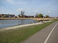
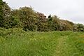
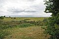
| Holland Haven | 22.1 | Clacton-on-Sea | Yes | SSSI | This country park has ponds, grasslands, and marsh. Over 200 bird species have been seen here, including purple sandpipers and avocets. It's a great place for birdwatching. |
| Home Mead | 1.8 | Loughton | Yes | This site has woodlands, scrub, and acid grassland. A wildflower meadow provides food for butterflies, and plants like bird's-foot trefoil grow in the scrub. | |
| Hoppit Mead | 9.2 | Braintree | Yes | This long site has formal park areas, wildflower meadows, and wet woodlands. The River Brain flows through it. The famous naturalist John Ray studied blackcurrant bushes here centuries ago. | |
| Hutton Country Park | 37.4 | Brentwood | Yes | Most of this park is natural grassland with many different plant species. It also has oak and hornbeam woodlands, ponds, and wetlands. You can see birds like moorhens and long-tailed tits, and butterflies like orange tips. | |
| Kendal Park | 2.8 | Hullbridge | Yes | This park has a wildflower meadow, coppiced woodland, grassland, and a pond. You'll find flowers like hoary cress and many types of butterflies. Birds like dunnocks and song thrushes live in the woodland. | |
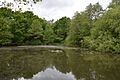
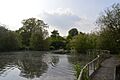
| Lexden Park | 8.1 | Colchester | PP | This site has grassland with many different plant species, such as lady's bedstraw. There's also oak woodland and a beautiful lake with wildfowl. | |
| Linder's Field | 3.9 | Buckhurst Hill | Yes | This area has ancient woodland, grassland, and ponds. The ponds are home to frogs, toads, and newts, and bats hunt in the hedgerows. Bluebells and wood anemones grow here. | |
| Linford Wood | 3.5 | East Tilbury | Yes | This site has mixed woodlands, willow trees, hedges, and ditches. Birds like tawny owls and great spotted woodpeckers live here. | |
| Magnolia Fields | 9.7 | Rochford | Yes | This used to be a brickworks, and you can still see signs of its past. It has a pond and many different birds, including bullfinches. | |
| Marylands | 3.7 | Hockley | Yes | Marylands has a wide variety of plants and animals, including 96 species of trees, shrubs, and herbs, and 13 types of butterflies. There's also a stream with sticklebacks. | |
| Mill Meadows, Billericay | 36.8 | Billericay | Yes | SSSI | This site has grassland, scrub, and woodlands. You might see badgers, stoats, and foxes, along with many bird species. Flowers like harebell and common spotted orchid grow here. |
| Nazeing Triangle | 0.5 | Harlow | Yes | This very small site is surrounded by roads. It has a pond with great crested newts and smooth newts, plus waterfowl and dragonflies. There's also a wildflower meadow with ox-eye daisy and bird's foot trefoil. | |
| Norsey Wood | 65.6 | Billericay | Yes | SM, SSSI | This is an ancient oak woodland with sphagnum mosses and the rare water violet in its ponds. Nine types of dragonflies live here. You can also find a Bronze Age burial mound. |
| Parndon Woods and Common | 50.5 | Harlow | Yes | SSSI | These woods are mainly oak and hornbeam trees. Other trees include ash, hazel, and birch. Some elm trees are growing back after Dutch elm disease. |
| Pickers Ditch Meadow | 1.9 | Clacton-on-Sea | Yes | This long site runs along Pickers Ditch. A footpath goes through the grassland, and hedges have been planted to screen the area. | |
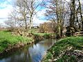
| Roding Valley Meadows | 65.2 | Buckhurst Hill | Yes | EWT, SSSI | These meadows are next to the River Roding. They are one of the largest areas of grassland in Essex managed as hay meadows and marshland. You can find the rare brown sedge here. |
| Roughtalley's Wood | 3.4 | North Weald Bassett | Yes | Part of this site is ancient woodland with hornbeam, oak, and silver birch trees. The younger woodland has wildflower glades with bee and common spotted orchids, slowworms, and grass snakes. | |
| Salary Brook | 17.1 | Colchester | Yes | This site has many different habitats, including the brook itself, pastures, ponds, and marsh. You can find four types of bats, water voles, lizards, nightingales, and reed warblers here. | |
| Shoeburyness Old Ranges | 6.4 | Shoeburyness | NO | EWT, SSSI | The plants here are unique in the county, growing on old sand dunes. There are areas of grasses and sedges, and rushes in damp spots. Rabbits graze the grassland, and you can see many lichens. |
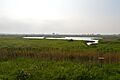
| Southend-on-Sea Foreshore | 1083.9 | Southend-on-Sea | Yes | Ramsar, SPA, SSSI | This 8.5-mile stretch of coast is super important for migrating birds from all over the world. Birds like bar-tailed godwits, dunlins, and teal nest or visit here. |
| Spring Lane Meadows | 2.0 | Colchester | PP | These wildflower meadows are grazed by cattle. You might spot kingfishers, snipe, and nightingales, as well as mammals like otters and noctule bats. | |
| Thornwood Common Flood Meadow | 3.0 | North Weald Bassett | Yes | This meadow was created to help prevent flooding in Thornwood village and is managed for nature. A wetland meadow, 800 trees, and a new hedge have been planted. Flowers include ragged robin and oxeye daisy. | |
| Tiptree Parish Field | 2.2 | Tiptree | Yes | This field has rough grassland with young oak woodlands. There's also a pond that was made by widening Layer Brook. | |
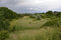
| Vange Hill | 11.5 | Basildon | Yes | This hill has grassland and scrub woodlands, surrounded by a drainage ditch. Some areas are mown, but others are left to grow, helping bumblebees and butterflies. You can find unusual plants like pale flax here. | |
| Weald Common Flood Meadows | 1.9 | North Weald Bassett | PP | These two meadows were created to help with flood defense and are managed for nature. They have a wet meadow with flowers like cowslips and ragged robin. Newts and frogs breed in the ponds, and grass snakes and common lizards bask in the sun. | |
| Welsh Wood | 3.2 | Colchester | Yes | Trees in this wood include ash, hazel, sweet chestnut, and the rare small-leaved lime. In spring, the ground is covered in bluebells, and you can also find wood anemones. Dead wood provides a home for stag beetle larvae. | |
| Whet Mead | 10.1 | Witham | Yes | Most of this former rubbish tip is now grassland with many different flowering plants. It's a great spot for butterflies, dragonflies, and seed-eating birds. You might also see wood mice and pygmy shrews. | |
| Wrabness | 27.0 | Wrabness | Yes | EWT | This site has grassland, marsh, scrub, and woodlands. It's home to many different birds, including yellowhammers and whitethroats. In winter, you can see visitors like black-tailed godwits and grey plovers. |
Images for kids
-
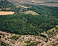
Belfairs
-
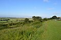
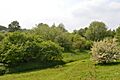
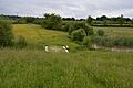
Belton Hills
-
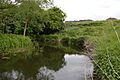
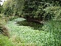
The River Blackwater in Bocking Blackwater
-
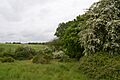
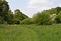
Brickfield and Long Meadow
-
Brockwell Meadows
-
Bull Meadow
-
Canvey Lake
-
Chelmer Valley Riverside
-
Chigwell Row Wood
-
Church Lane Flood Meadow
-
Colne
-
Colne Valley
-
Cuckoo Wood
-
Fenn Washland
-

Galleywood Common
-
Gosfield Sandpits
-
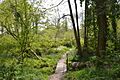
Grove House Wood
-
Parndon Moat Marsh
-
Hawkenbury Meadow
-
Hilly Fields
-
Hockley Woods
-
Holland Haven
-
Home Mead
-
Hoppit Mead
-
Hutton Country Park
-
Kendal Park
-
Lexden Park
-
Linder's Field
-
Linford Wood
-
Magnolia Fields
-
Marylands
-
Mill Meadows
-
Nazeing Triangle
-
Norsey Wood
-
Parndon Wood Conservation Centre
-
Pickers Ditch Meadow
-
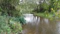
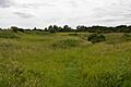
River Roding in Roding Valley Meadows
-
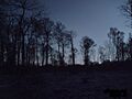
Roughtalley's Wood
-
Salary Brook
-
Shoeburyness Old Ranges
-
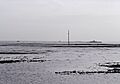
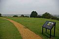
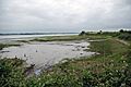
Southend-on-Sea Foreshore
-
Spring Lane Meadows
-
Thornwood Common Flood Meadow
-
Tiptree Parish Field
-
Vange Hill
-
Weald Common Flood Meadows
-
Welsh Wood
-
Whet Mead
-
Wrabness
_-_geograph.org.uk_-_1770279.jpg)


More Information
- List of Sites of Special Scientific Interest in Essex
- Essex Wildlife Trust
