
List of national monuments in County Cork facts for kids
The Irish government has officially recognized many amazing old places in County Cork as "national monuments." This means these sites are super important to Ireland's history and are protected by the state. Sometimes, even the land around them is protected to keep them safe. Think of them as special treasures from the past!
Contents
Exploring Cork's Ancient Treasures
County Cork is full of incredible historical sites. These monuments tell us stories about how people lived, worshipped, and defended themselves thousands of years ago, right up to more recent times. Let's explore some of these fascinating places!
Mighty Castles and Strong Forts
Ireland is famous for its castles, and Cork has many! These strong buildings were often homes for powerful families or important defense points.
- Ballinacarriga Castle: Located near Dunmanway, this castle is a great example of a tower house. These were popular types of castles in Ireland, built for defense and living.
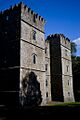
- Barryscourt Castle: Near Carrigtwohill, this castle is a well-preserved example of a 15th-century tower house. It has been restored, so you can really imagine what life was like there long ago.
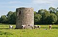
- Ballybeg Tower: This tower is part of a larger complex near Buttevant. Towers like this were often used for defense or as part of a larger monastery.
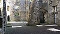
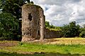
- Glanworth Castle: Found in Glanworth, this castle is a medieval fortress. It stands as a reminder of the powerful families who once controlled this area.
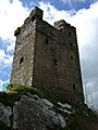
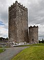
- Carrigaphooca Castle: This castle near Macroom is perched on a rocky outcrop, making it very hard to attack. Its name means "rock of the fairy."
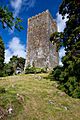
- Castledonovan Castle: Located in West Cork, this castle was once a stronghold of the O'Donovan clan. It's a tall, impressive ruin that shows how strong these buildings were.
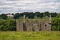
- Mallow Castle: In Mallow, this castle has a rich history. It's a beautiful example of a fortified house.
- Conna Castle: This castle near Fermoy is another fine example of a tower house, showing the architectural style of the time.
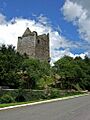
- Drishane Castle: Near Millstreet, this castle has been standing for centuries, watching over the landscape.
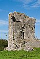
- Dromaneen Castle: Also in North Cork, this castle is a historic ruin that tells tales of past battles and powerful families.
- Kilbolane Castle: Near Milford, this castle is a significant historical site, showing the remains of a once-grand structure.
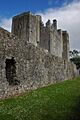
- Liscarroll Castle: This large castle near Buttevant is one of the biggest in County Cork. Its strong walls tell a story of medieval power.
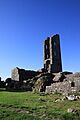
- Kanturk Castle: Near Kanturk, this impressive castle was never fully finished, but its size shows the ambition of its builders.
- Desmond Castle: In Kinsale, this tower house was once used as a prison, earning it the nickname "The French Prison."
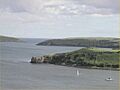
- Charles Fort and James Fort: These two amazing star-shaped forts guard the entrance to Kinsale harbour. They were built to protect the town from attacks by sea, especially from the French and Spanish.
Ancient Burial Sites and Stone Circles
Many national monuments are prehistoric sites, built by people thousands of years ago. These include tombs and mysterious stone circles.
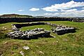
- Altar Wedge Tomb: This ancient burial site near Schull is a type of tomb called a "wedge tomb." These tombs were built by early farmers and are shaped like a wedge, getting narrower at one end.
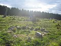
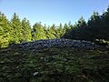
- Breeny More Stone Circle: Located in West Cork, this stone circle is a prehistoric monument, possibly used for ceremonies or marking important dates. It also has "boulder burials," which are large stones covering graves.
- Carrigagulla: This stone circle near Macroom is another example of ancient human activity in Cork. Stone circles are still a bit of a mystery, but they were very important to the people who built them.
- Derryarkane Stone Circle: Found in West Cork, this site includes a stone circle and a standing stone, showing ancient ritual practices.
- Drombeg: This is one of Ireland's most famous stone circles, located near Glandore. It's often called the "Druid's Altar" and includes a hut site and a fulacht fiadh (an ancient cooking site).
- Island Wedge Tomb: Another wedge tomb, this one is near Mallow. It's a reminder of the early communities who lived and buried their dead here.
- Knocknakilla: This stone circle near Millstreet is a fascinating prehistoric site, showing the widespread practice of building these monuments.
- Labbacallee wedge tomb: This is one of the largest and most impressive wedge tombs in Ireland, located near Fermoy. It gives us a great look into ancient burial customs.
- Lissacresig Stone Circle: Near Macroom, this stone circle adds to the many prehistoric sites in Cork.
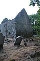
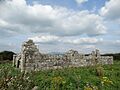
- Skeagh Cairn: This site near Skibbereen includes a ring barrow and a cairn, which are types of ancient burial mounds.
Sacred Churches and Abbeys
Many national monuments are the remains of churches, abbeys, and friaries, showing the long history of Christianity in Ireland.
- Ardskeagh Church: This church ruin near Fermoy is a historical reminder of early Christian settlements.
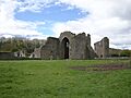
- Ballybeg Abbey: Near Buttevant, this was an Augustinian friary, a type of monastery where friars lived and prayed.
- Templekieran, Clear Island: On Cape Clear Island, this site includes a church and a cross-inscribed pillar, showing early Christian art.
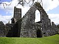
- Rock Abbey, Glanworth: This was a Franciscan friary near Glanworth. Friaries were important centers for learning and religion in medieval times.
- Buttevant Abbey: Another Franciscan friary, this one is in Buttevant. These abbeys were often very large and important to the local community.
- Coole Upper Churches: This site near Fermoy has the remains of two churches, showing how religious life developed over time.
- Sherkin Abbey: On Sherkin Island, this 15th-century Franciscan friary is a beautiful ruin overlooking the sea.
- Kileenemer Church: This church near Fermoy is another example of Cork's rich religious heritage.
- Kilcrea Abbey: Near Ovens, this Franciscan friary is a well-preserved ruin, often visited for its historical significance.
- Labbamolaga Church: This ancient church near Mitchelstown includes grave slabs, giving us clues about the people buried there.
- Castlelyons Friary: This Carmelite friary near Fermoy is another important religious site in the county.
- Timoleague Abbey: This Franciscan friary near Clonakilty is a very picturesque ruin, standing by the water.
- Tullylease Church: In North Cork, this church is known for its ancient grave slabs and historical importance.
- North Abbey, Youghal: This Dominican friary in Youghal is a significant ruin, showing the presence of different religious orders.
Other Important Sites
Cork also has other types of national monuments, from ancient forts to unique historical markers.
- Ballybeg Dovecote: Near Buttevant, a dovecote is a building used to house pigeons or doves. These were important for food and messages in medieval times.
- Blossomfort: This is a "ringfort," a type of circular enclosed settlement from the Iron Age or early medieval period. Many of these dot the Irish landscape.
- Cahervagliar: Another ringfort, this one is near Macroom, showing the common settlement patterns of early Ireland.
- Carn Tierna: This site near Fermoy is a "hillfort" and a "cairn." Hillforts were large defensive enclosures on hills, and cairns are stone mounds, often over burials.
- Clodagh Standing Stones: Near Bantry, these are a pair of standing stones, possibly marking a boundary or a sacred spot.
- Coolcoulaghta Standing Stones: Another pair of standing stones, these are near Schull, adding to the mystery of ancient stone alignments.
- Derryarkane Stone Circle: This site near Bantry includes a stone circle and a standing stone.
- Farranahineeny Stone Row: Near Dunmanway, a stone row is a line of standing stones, often connected to astronomical events or rituals.
- Knockdrum Stone Fort: Near Union Hall, this is a "cashel," which is a stone-built ringfort. It's a very well-preserved example.
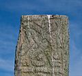
- Ballycrovane Ogham Stone: Located on the Beara Peninsula, this is one of the tallest Ogham stones in Ireland. Ogham is an ancient Irish alphabet carved into stones.
- Greenhill Ogham Stones: These Ogham stones near Mallow are another example of this unique ancient writing.
- Kilnaruane Carved Pillar Stone: Near Bantry, this pillar stone has intricate carvings and is believed to be part of an early Christian high cross.
- Maughanasilly Stone Row: Another stone row, this one is near Bantry, showing the widespread use of these monuments.
- Mount Gabriel: This mountain near Schull is home to prehistoric copper mines, showing that people were mining here thousands of years ago!
- Kinneigh Round Tower: Near Enniskeane, this round tower is unique because it has a hexagonal (six-sided) base, unlike most round towers which are circular all the way up.
- Michael Collins birth place: This site near Clonakilty is important because it's where Michael Collins, a very famous figure in Irish history, was born.
These national monuments are amazing windows into Ireland's past. They help us understand the lives of people who came before us, from ancient farmers to medieval monks and powerful chieftains. Protecting them ensures that future generations can also learn from these incredible historical treasures.
Images for kids
-
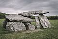
The Altar Wedge Tomb, an ancient burial site.
-
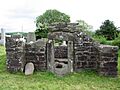
The dovecote at Ballybeg.
-
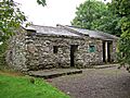
The tower at Ballybeg.
-
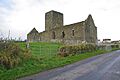
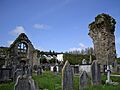
Ballybeg Abbey, an Augustinian friary.
-
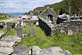
Templekieran Church on Clear Island.
-
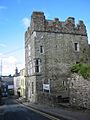
Ballinacarriga Castle, a historic tower house.
-
Barryscourt Castle, a restored 15th-century tower house.
-

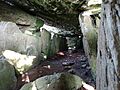
Interior of the medieval tower at Glanworth.
-
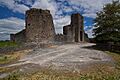
Glanworth Castle.
-
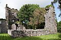
Rock Abbey, Glanworth Friary.
-
Buttevant Abbey, a Franciscan friary.
-
The stone circle at Carrigagulla.
-
Carrigaphooca Castle, built on a rocky outcrop.
-
Castledonovan Castle in West Cork.
-
Mallow Castle.
-
Conna Castle.
-
One of the Coole Upper Churches.
-
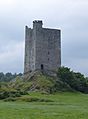
Drishane Castle.
-
Dromaneen Castle.
-
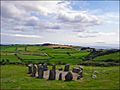
The famous Drombeg Stone Circle.
-
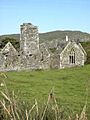
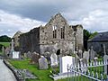
Sherkin Abbey.
-
Knockdrum Stone Fort (Cashel).
-
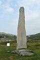
The tall Ballycrovane Ogham Stone.
-
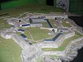
Plan of Charles Fort in Kinsale.
-
Kilbolane Castle.
-
Kilcrea Abbey.
-
Kileenemer Church.
-
The carved Kilnaruane Pillar Stone.
-
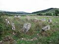
Knocknakilla Stone Circle.
-
Inside the Labbacallee Wedge Tomb.
-
Labbamolaga Church.
-
Liscarroll Castle.
-
Castlelyons Friary.
-
The blockhouse at James Fort, Kinsale.
-
Kanturk Castle.
-
Skeagh Cairn, an ancient burial mound.
-
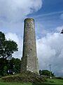
Kinneigh Round Tower, with its unique hexagonal base.
-

Timoleague Abbey.
-
Desmond Castle in Kinsale.
-

Tullylease Church.
-
The birthplace of Michael Collins.
-
North Abbey, Youghal.


