Boundary Ranges facts for kids
Quick facts for kids Boundary Ranges |
|
|---|---|
| Alaska Boundary Range | |

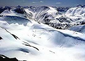
View of the Juneau Icefield.
|
|
| Highest point | |
| Peak | Mount Ratz (British Columbia) |
| Elevation | 3,090 m (10,140 ft) |
| Dimensions | |
| Area | 87,101 km2 (33,630 sq mi) |
| Geography | |
| Countries | Canada and United States |
| Parent range | Coast Mountains |
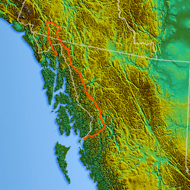
The Boundary Ranges are a large group of mountains. They are also known as the Alaska Boundary Range. These mountains are the biggest and most northern part of the Coast Mountains. They stretch across parts of Canada and the United States.
The Boundary Ranges start near the Nass River in British Columbia, Canada. They go all the way to the Kelsall River, near the Chilkoot Pass. From there, they continue north into the Yukon Territory. They run alongside the Yukon River up to Champagne Landing. To their east are other mountain groups like the Skeena Mountains. The Alexander Archipelago is a group of islands offshore in Alaska.
Contents
Exploring the Boundary Ranges
The Boundary Ranges are famous for their huge areas of ice and snow. These are called icefields. Two of the largest are the Juneau Icefield and the Stikine Icecap.
Giant Icefields and Tall Peaks
The Juneau Icefield is found between the city of Juneau in Alaska and Atlin Lake in British Columbia. The Stikine Icecap is located between the Stikine River and the Whiting River.
Some of the tallest mountains in the Boundary Ranges include:
- Mount Ratz, which is about 3,090 m (10,138 ft) (10,138 feet) tall.
- Chutine Peak, standing at about 2,910 m (9,547 ft) (9,547 feet).
- Devils Thumb, reaching about 2,766 m (9,075 ft) (9,075 feet).
- Devils Paw, which is about 2,593 m (8,507 ft) (8,507 feet) tall.
Even though Mount Ratz and its neighbors are very high, most of the Boundary Ranges are not as tall as the mountains further south in the Coast Mountains. The icefields here are at lower elevations than those in the southern parts of the Coast Mountains. This is because of the different latitude.
How the Mountains Formed
The rocks that make up the Boundary Ranges are mostly granite. These rocks were formed from melted rock deep inside the Earth. They are what's left of an ancient chain of volcanoes. This volcanic chain was active a very long time ago, during the Late Cretaceous period.
Parts of the Boundary Ranges
The Boundary Ranges are made up of many smaller mountain groups and icefields. Here are some of them:
- Boundary Range
- Cheja Range
- Chechidla Range
- Chutine Icefield
- Adam Mountains
- Ashington Range
- Burniston Range
- Dezadeash Range
- Florence Range
- Halleck Range
- Juneau Icefield
- Kahpo Mountains
- Kakuhan Range
- Lincoln Mountains
- Longview Range
- Peabody Mountains
- Rousseau Range
- Seward Mountains
- Snowslide Range
- Spectrum Range
- Stikine Icecap
Rivers of the Boundary Ranges
Many rivers flow through or start in the Boundary Ranges. These rivers help shape the landscape and provide homes for wildlife. Here are some of the important rivers:
- Chilkat River
- Choquette River
- Craig River
- Iskut River
- Kelsall River
- Keta River
- King Salmon Creek
- Klehini River
- Lava Fork
- Nass River
- Porcupine River
- Salmon River
- Skagway River
- Stikine River
- Taiya River
- Taku River
- Tulsequah River
- Unuk River
- Whiting River
See also
 In Spanish: Cordilleras Fronterizas para niños


