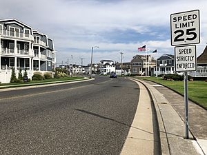
Longport, New Jersey facts for kids
Quick facts for kids
Longport, New Jersey
|
||
|---|---|---|
|
Borough
|
||
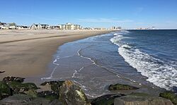
Longport Beach
|
||
|
||
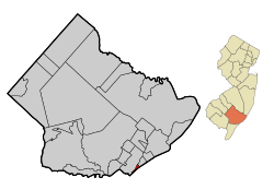
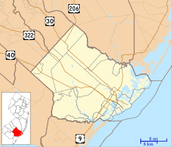
Location of Longport in Atlantic County highlighted in red (left). Inset map: Location of Atlantic County in New Jersey highlighted in orange (right).
|
||
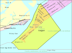
Census Bureau map of Longport, New Jersey
|
||
| Country | ||
| State | ||
| County | Atlantic | |
| Incorporated | March 7, 1898 | |
| Named for | James Long | |
| Government | ||
| • Type | Walsh Act | |
| • Body | Board of Commissioners | |
| Area | ||
| • Total | 1.56 sq mi (4.03 km2) | |
| • Land | 0.40 sq mi (1.02 km2) | |
| • Water | 1.16 sq mi (3.01 km2) 74.49% | |
| Area rank | 447th of 565 in state 23rd of 23 in county |
|
| Elevation | 0 ft (0 m) | |
| Population
(2020)
|
||
| • Total | 893 | |
| • Estimate
(2023)
|
878 | |
| • Rank | 538th of 565 in state 22nd of 23 in county |
|
| • Density | 2,259.8/sq mi (872.5/km2) | |
| • Density rank | 277th of 565 in state 7th of 23 in county |
|
| Time zone | UTC−05:00 (Eastern (EST)) | |
| • Summer (DST) | UTC−04:00 (Eastern (EDT)) | |
| ZIP Code |
08403
|
|
| Area code(s) | 609 exchanges: 487, 822, 823 | |
| FIPS code | 3400141370 | |
| GNIS feature ID | 0885286 | |
Longport is a small town called a borough in New Jersey. It's located right on the Atlantic Ocean shoreline on Absecon Island, which is part of Atlantic County. It's a beautiful spot along the Jersey Shore.
In 2020, about 893 people lived in Longport. This number was a little less than in 2010. Longport is also part of the larger Atlantic City area. In 2018, Longport was listed as one of the most expensive places to live in New Jersey.
Contents
History of Longport
Longport got its name from a man named James Long. He bought some land here in 1857. Over time, the land grew bigger as sand built up, and more property was bought. In 1882, M. Simpson McCullough bought the land and decided to name the community "Longport" to honor James Long.
Longport officially became a borough on March 7, 1898. This happened thanks to a decision by the New Jersey Legislature. It was created from parts of Egg Harbor Township.
In 2014, some people from a nearby area called Seaview Harbor wanted to join Longport. They felt it was hard to get to the rest of their own township and their taxes were high. However, in 2016, their request to join Longport was not approved.
Geography and Location
Longport is a small area, covering about 1.56 square miles (4.03 square kilometers). Most of this area, about 74%, is water, and the rest is land.
Longport is found at the southwest end of Absecon Island. This island is about 8.1 miles long. Other towns on this island include Margate City, Ventnor City, and Atlantic City.
Some of the streets at the southern end of Longport start at 11th Avenue. This is because a series of storms between 1900 and 1916 washed away the land where the first ten numbered streets used to be.
Population and People
| Historical population | |||
|---|---|---|---|
| Census | Pop. | %± | |
| 1900 | 80 | — | |
| 1910 | 118 | 47.5% | |
| 1920 | 200 | 69.5% | |
| 1930 | 228 | 14.0% | |
| 1940 | 303 | 32.9% | |
| 1950 | 618 | 104.0% | |
| 1960 | 1,077 | 74.3% | |
| 1970 | 1,225 | 13.7% | |
| 1980 | 1,249 | 2.0% | |
| 1990 | 1,224 | −2.0% | |
| 2000 | 1,054 | −13.9% | |
| 2010 | 895 | −15.1% | |
| 2020 | 893 | −0.2% | |
| 2023 (est.) | 878 | −1.9% | |
| Population sources: 1900–2000 1900–1920 1900–1910 1910–1930 1940–2000 2000 2010 2020 |
|||
In 2010, there were 895 people living in Longport. The average household had about two people. Many people living in Longport are 65 years old or older. The median age was 58.2 years.
Fun and Activities
Longport's beaches are great for surfing and other water sports. It's a popular place for people who love the ocean!
Schools and Learning
Students from Longport attend public schools in nearby towns.
- For kindergarten through eighth grade, students go to the Margate City Schools in Margate City. The schools there are William H. Ross III Elementary School (K-4) and Eugene A. Tighe Middle School (5-8).
- For high school (grades 9-12), students attend Ocean City High School in Ocean City. This change happened in the 2014-2015 school year. Before that, students went to Atlantic City High School. The change was made to save money on tuition costs.
There are also other school choices for students in the area:
- The Atlantic County Institute of Technology offers special training programs.
- The Charter-Tech High School for the Performing Arts focuses on arts education.
- Private schools like Holy Spirit High School and St. Augustine Preparatory School are also available.
Getting Around Longport
Longport has about 13.56 miles of roads. Most of these roads are maintained by the town itself. There are no major highways that go directly through Longport. You'll find smaller county roads, like County Route 629.
You can get to the mainland and to Ocean City by using a series of bridges. These include the JFK Memorial Bridge and the Dolores G. Cooper Bridge, which is also known as the Longport-Somers Point Boulevard.
For public transportation, NJ Transit offers bus service. The 505 bus route connects Longport to Atlantic City.
Weather in Longport
Longport has a humid subtropical climate. This means it has hot, somewhat humid summers and cool winters. It rains throughout the year.
In summer, a cool sea breeze often blows in the afternoon. However, it can sometimes get very hot and humid. In winter, it can get very cold and windy. The area usually gets about 12 to 18 inches of snow each winter, with February often being the snowiest month.
| Climate data for Longport Beach, NJ (1981–2010 Averages) | |||||||||||||
|---|---|---|---|---|---|---|---|---|---|---|---|---|---|
| Month | Jan | Feb | Mar | Apr | May | Jun | Jul | Aug | Sep | Oct | Nov | Dec | Year |
| Mean daily maximum °F (°C) | 41.4 (5.2) |
43.5 (6.4) |
50.2 (10.1) |
59.7 (15.4) |
68.9 (20.5) |
77.8 (25.4) |
82.6 (28.1) |
81.4 (27.4) |
76.0 (24.4) |
65.4 (18.6) |
56.0 (13.3) |
46.3 (7.9) |
62.5 (16.9) |
| Daily mean °F (°C) | 33.7 (0.9) |
35.7 (2.1) |
42.1 (5.6) |
51.5 (10.8) |
60.7 (15.9) |
70.1 (21.2) |
75.3 (24.1) |
74.1 (23.4) |
68.1 (20.1) |
57.3 (14.1) |
48.0 (8.9) |
38.6 (3.7) |
54.7 (12.6) |
| Mean daily minimum °F (°C) | 26.0 (−3.3) |
28.0 (−2.2) |
34.0 (1.1) |
43.2 (6.2) |
52.5 (11.4) |
62.3 (16.8) |
67.9 (19.9) |
66.8 (19.3) |
60.2 (15.7) |
49.1 (9.5) |
40.0 (4.4) |
30.9 (−0.6) |
46.8 (8.2) |
| Average precipitation inches (mm) | 3.28 (83) |
2.89 (73) |
4.20 (107) |
3.64 (92) |
3.27 (83) |
3.01 (76) |
3.47 (88) |
4.18 (106) |
3.12 (79) |
3.62 (92) |
3.37 (86) |
3.87 (98) |
41.92 (1,065) |
| Average relative humidity (%) | 68.1 | 66.7 | 63.5 | 63.9 | 68.6 | 72.4 | 72.6 | 74.8 | 72.9 | 71.6 | 69.8 | 68.4 | 69.5 |
| Average dew point °F (°C) | 24.3 (−4.3) |
25.7 (−3.5) |
30.6 (−0.8) |
39.7 (4.3) |
50.3 (10.2) |
60.8 (16.0) |
65.9 (18.8) |
65.6 (18.7) |
59.1 (15.1) |
48.2 (9.0) |
38.6 (3.7) |
29.1 (−1.6) |
44.9 (7.2) |
| Source: PRISM | |||||||||||||
| Climate data for Atlantic City, NJ Ocean Water Temperature (6 NE Longport) | |||||||||||||
|---|---|---|---|---|---|---|---|---|---|---|---|---|---|
| Month | Jan | Feb | Mar | Apr | May | Jun | Jul | Aug | Sep | Oct | Nov | Dec | Year |
| Daily mean °F (°C) | 37 (3) |
35 (2) |
42 (6) |
48 (9) |
56 (13) |
63 (17) |
70 (21) |
73 (23) |
70 (21) |
61 (16) |
53 (12) |
44 (7) |
54 (12) |
| Source: NOAA | |||||||||||||
Nature and Plants
The natural plants in Longport are mostly a type of grass called Northern Cordgrass. This kind of plant grows well in coastal areas like a Coastal Prairie.
Famous People from Longport
Many interesting people have lived in or are connected to Longport:
- Leland Beloff (born 1942) was a politician who served in the Pennsylvania House of Representatives and the Philadelphia City Council.
- Jack Crawford (born 1988) is a professional American football player who played for the Oakland Raiders.
- Thomas Cruse (1857–1943) was a United States Army general who received the Medal of Honor for his bravery.
- Louis Johanson (1929–2004) was a politician who served in the Pennsylvania State Senate and the Philadelphia City Council.
- Howard Kupperman (1931–2014) was a politician who served in the New Jersey General Assembly and was also the mayor of Longport from 1983 to 1992.
- Heinie Miller (1893–1964) was an early professional football player in the National Football League.
- Paul Steelman (born 1955) is a well-known architect.
- James Tate (1910–1983) was the mayor of Philadelphia from 1962 to 1972.
See also
 In Spanish: Longport para niños
 | May Edward Chinn |
 | Rebecca Cole |
 | Alexa Canady |
 | Dorothy Lavinia Brown |


