
Longridge Fell facts for kids
Quick facts for kids Longridge Fell |
|
|---|---|

The east end of Longridge Fell, with Pendle Hill behind, to the left
|
|
| Highest point | |
| Elevation | 1,148 ft (350 m) |
| Prominence | 794 ft (242 m) |
| Parent peak | Ward's Stone |
| Listing | Marilyn |
| Geography | |

Longridge Fell
Location in Lancashire

Longridge Fell
Location in the Borough of Ribble Valley

Longridge Fell
Location in the Forest of Bowland
|
|
| Location | Lancashire, England |
| OS grid | SD658410 |
Longridge Fell is a cool natural landmark in Lancashire, England. It's the most southerly fell in the country. A "fell" is a type of hill or mountain, often found in northern England. This long, narrow hill is close to the town of Longridge. It sits at the southern edge of the Forest of Bowland, which is a special Area of Outstanding Natural Beauty.
As its name suggests, Longridge Fell is a long, ridge-shaped hill. It stretches about 4.5 miles from Longridge town towards the northeast. The ridge then curves east and ends suddenly, dropping into the Hodder Valley. Longridge Fell is a great example of a cuesta. This means it has one steep side and one gentler, more varied slope. The steep side, called an escarpment, faces north. The southern side slopes more gently. These features make it a popular spot for hang-gliding and paragliding. This happens when the wind blows from the north, which isn't very often!
Contents
Amazing Views from the Top
From the very top of Longridge Fell, you can see for miles! The summit is 1,148 feet (350 meters) high. On a clear day, the views are truly incredible.
- To the southwest, you can spot the city of Preston.
- Looking west, you might see the Fylde Coast.
- To the north and west, you'll see the Vale of Chipping. You can also see other fells in the Forest of Bowland, like Parlick, Fair Snape Fell, and Beacon Fell.
- The Yorkshire Dales are visible to the northeast, including the famous Pen-y-ghent.
- To the east and southeast, you can see Clitheroe, Pendle Hill, and Whalley.
- You might also spot Winter Hill and the West Pennine Moors. The BAE Systems factory at Samlesbury Aerodrome is also in view.
- On very clear days, you might even see the Lake District and sometimes the Isle of Man to the northwest. Far to the southwest, the Snowdonia mountain range in Wales can sometimes be seen!
Rivers and Nearby Villages
Several rivers flow around Longridge Fell. The River Hodder and its smaller branch, the River Loud, flow eastward along the north side of the fell. They then turn south at the end of the fell. These rivers eventually join the River Ribble, which flows westward along the south side of the fell.
Another small stream, Cowley Brook, starts near the fell. It's a branch of Stydd Brook. On the south side of the fell, you'll find the village of Hurst Green. Right next to it is Stonyhurst College, a famous old school.
Longridge Town and Quarries
The town of Longridge is located at the southwest end of the fell. In the past, there were many stone quarries here, especially at a place called Tootle Heights. Most of these old quarries have now been built over. However, there's still a deep, water-filled part of a quarry off the Tan Yard bridlepath. There are also some reservoirs nearby.
One of these is the Dilworth Upper Reservoir. It's located between two roads, where Forty Acre Lane branches off Higher Road. Higher Road leads from Longridge up the fell. Forty Acre Lane goes towards Jeffrey Hill, which is a small part of the western section of the fell. This area is also home to Longridge Golf Club. Their clubhouse is also used by the Preston Wheelers Cycling Club. Below Tootle Heights, you'll find the Spade Mill Reservoirs.
Images for kids
-
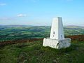
The trig point at the summit of Longridge Fell, looking north
-
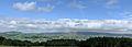
A view from the northern section of Longridge golf course across the Vale of Chipping to Parlick and Fair Snape Fell
-
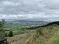
View over the Vale of Chipping
-
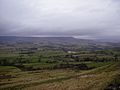
View north over the Loud Valley
-
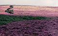
The western slopes of the fell, around Jeffrey Hill


.jpg)

