Low Head Lighthouse facts for kids
 |
|
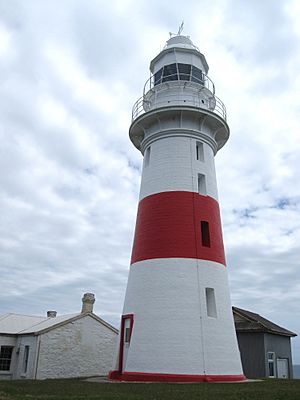
| View of Low Head Lighthouse, looking to the northwest in 2010. Generator sheds are visible behind the tower | |
|
|
|
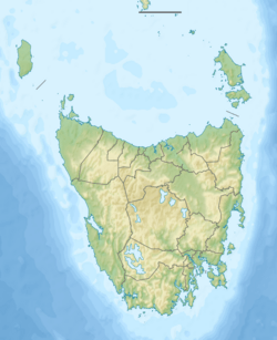
| Location | Low Head (on Bass Strait) George Town Tasmania Australia |
|---|---|
| Coordinates | 41°03′1.5″S 146°47′22.0″E / 41.050417°S 146.789444°E |
| Year first constructed | 1833 |
| Year first lit | 1833 |
| Automated | 1995 |
| Foundation | concrete base |
| Construction | brick tower |
| Tower shape | cylindrical tower with balcony and lantern |
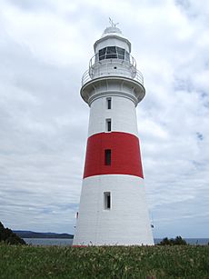
| Markings / pattern | white tower with red horizontal bands at base and midsection White metal lantern and gallery |
| Height | 19 metres (62 ft) |
| Focal height | 43 metres (141 ft) |
| Original lens | Fresnel lens, Wilkins and Company, London |
| Intensity | 50,000 cd (1000 watt, 240 volt tungsten-halogen lamp) |
| Range | 43 kilometers (23 nmi) |
| Characteristic | Fl(3) W 30s. |
| Fog signal | Type G diaphone, installed in 1929 |
| NGA number | 7088 |
| ARLHS number | AUS–101 |
The Low Head Lighthouse is a famous landmark in Low Head, Tasmania. It's about 7 kilometers north of George Town, right at the entrance of the Tamar River. This lighthouse was the third one ever built in Australia. It's also Australia's oldest continuously used pilot station, which is a place where special guides (pilots) help ships navigate tricky waters. Today, the lighthouse works all by itself, without people living there.
Contents
History of the Low Head Lighthouse
In 1798, explorers George Bass and Matthew Flinders sailed around Tasmania (then called Van Diemen's Land). They landed at a spot they named Port Dalrymple, which is now George Town. They discovered that Tasmania was an island, separate from mainland Australia. Flinders noted that it was hard to find the entrance to the Tamar River.
To help ships, Colonel William Paterson set up a simple flagpole at Low Head in 1804. This was the first navigation marker. Later that year, he created a pilot station and a signal station. He also started a fire beacon at Low Head. When a ship was seen after dark, convicts would light a big fire and keep it burning all night. This helped ships see the port entrance.
Shipwrecks and the First Lighthouse
Many serious shipping accidents happened near the Tamar River entrance. One of the most well-known was in 1808, when the ship Hebe hit a reef between Low Head and Western Head. The ship was wrecked on these rocks, which are now called Hebe Reef. Because of these dangers, a group called the Committee of Pilotage suggested in 1826 that a lighthouse should be built at Low Head.
Australia's first lighthouse, Macquarie Lighthouse, was lit in 1793. The second, Iron Pot Lighthouse in Tasmania, started working in 1832. The Low Head Lighthouse was built by convict labour and first lit on December 27, 1833. It became Tasmania's second lighthouse and the third in all of Australia.
The Low Head Lighthouse has helped prevent many accidents since 1833. However, some ships have still been lost. Since the Hebe in 1808, nine more ships have been wrecked on Hebe Reef. The most recent was the MV Iron Baron in 1995. This ship ran aground on Hebe Reef, causing a large oil spill. Luckily, all the crew members were safely rescued.
The Lighthouse Tower Over Time
The first lighthouse tower was 15.25 meters tall and was known as the "Georgetown Station." It was designed by John Lee Archer, a colonial architect. The tower was built from local rubble (rough stones) and covered with stucco (a type of plaster) to make it strong. The top part and the lantern room were made from freestone and timber from Launceston.
By the 1880s, the original stone tower was getting old. So, in 1888, it was taken down and replaced with the current tower. This new tower was built with double bricks and had a new lantern room. At first, it was painted all white. Then, on January 5, 1926, a wide, bright red band was painted around the middle. This made the lighthouse easier to see during the day.
Lighthouse Keepers' Homes
The Low Head Lighthouse was staffed by a superintendent and two convict assistants. These assistants were locked in their living areas overnight. The first lighthouse keeper's quarters had four rooms attached to the base of the tower. Low Head was the only lighthouse in Tasmania built with homes connected to the tower.
In 1890, a new home for the Head Keeper was built. Later, in 1916, an Assistant Keeper's home was built nearby.
How the Light and Lens Changed
The first lighting system in 1833 used Argand lamps with tin reflectors. In 1835, a revolving shutter was added. This shutter was turned by a clockwork mechanism powered by weights. In 1838, the original whale oil lamps and tin mirrors were replaced. A new revolving catadioptric system was installed, which used lenses and prisms to focus the light. This lens floated and spun in a bath of mercury, which helped it turn smoothly.
When the new tower was built in 1888, the revolving catadioptric system was kept. A new cast iron and copper housing for the lantern was also added.
In 1898, an extra light was put on the tower. This light had a red lens and produced a red warning light. It was meant to shine on the dangerous Hebe Reef. This red light comes from a window about 6 meters below the main light.
In 1916, the lighting system got a big upgrade. A new revolving Fresnel lens was installed. This lens was much more powerful. The whale oil lantern was replaced with a incandescent gas mantle lantern, which used vaporized kerosene for fuel.
On April 12, 1937, the Low Head Lighthouse finally got hydroelectric power from a nearby power station. The old clockwork system was replaced by an electric motor. The kerosene lantern was replaced by a 110-volt electric lamp. Today, the lantern uses a 240-volt lamp.
The Foghorn's Story
Tasmania's only foghorn is at Low Head Lighthouse. It's a special Type G diaphone that was installed in April 1929. Lighthouse keepers used to operate this foghorn during foggy weather for over 40 years. The original system used kerosene engines to power air compressors. These compressors filled large compressed air receivers. The air then made the loud sound, which could be heard up to 32 kilometers away! In 1940, the foghorn was also changed to run on electricity.
This foghorn is one of the largest diaphones ever built. It was stopped in 1973 because new technology made it less necessary. For many years, it fell apart. But in 2000, a local group started a project to fix it. In April 2001, the foghorn worked again! Today, the Low Head Lighthouse foghorn is one of only two working Type G diaphones in the world. You can hear it every Sunday at noon.
How They Communicated
From 1804, flag signals (like semaphore flags) were used to share news about ships in the Bass Strait with the Low Head Lighthouse. From there, these signals would be relayed to George Town and other places, and then all the way to Launceston.
This flag system was replaced in 1859 by an electric telegraph system. This happened when Tasmania was connected to mainland Australia by an undersea cable that came ashore at Low Head. The first undersea telephone cable linking Tasmania to mainland Australia was laid between Low Head and Flinders, Victoria in 1936.
The Lighthouse Keepers
From 1865 to 1912, the Low Head Lighthouse was managed by Alfred C. Rockwell and his son, Alfred C. Rockwell Junior. The lighthouse station was also in charge of smaller lights on the Tamar River, which had their own staff for some years.
Nearby lighthouses
- Tamar River Leading Lights (41°04.8′S 146°48.3′E / 41.0800°S 146.8050°E)
- Mersey River Leading Lights (41°10.7′S 146°21.7′E / 41.1783°S 146.3617°E)
- Mersey Bluff Lighthouse (41°10′S 146°21′E / 41.167°S 146.350°E)
- Round Hill Point (41°03.9′S 145°57.7′E / 41.0650°S 145.9617°E)
- Highfield Bluff (40°44.4′S 145°17.3′E / 40.7400°S 145.2883°E)
- Rocky Cape Lighthouse (40°51.3′S 145°30.4′E / 40.8550°S 145.5067°E)
- Table Cape Lighthouse (40°56.9′S 145°43.8′E / 40.9483°S 145.7300°E)
 | William M. Jackson |
 | Juan E. Gilbert |
 | Neil deGrasse Tyson |


