
Beauchief and Greenhill facts for kids
Quick facts for kids Beauchief and Greenhill |
|
|---|---|
 Shown within Sheffield |
|
| Population | 19,669 (2016) |
| Metropolitan borough | |
| Metropolitan county | |
| Region | |
| Country | England |
| Sovereign state | United Kingdom |
| EU Parliament | Yorkshire and the Humber |
| UK Parliament |
|
| Councillors | Simon Clement-Jones (Liberal Democrats) Sophie Thornton(Liberal Democrats) Richard Craig Thomas Shaw (Liberal Democrats) |
The Beauchief and Greenhill ward is one of 28 special areas in the City of Sheffield, England, that helps organize local elections. It includes several districts like Batemoor, Beauchief, Chancet Wood, Greenhill, Jordanthorpe, Lowedges and Meadowhead. This ward is located in the southern part of Sheffield and covers about 2.4 square miles (6.2 km²). In 2016, around 19,669 people lived here in 9,209 homes.
This area is also part of the Sheffield Heeley parliamentary constituency, which is how people in this part of Sheffield vote for their representative in the UK Parliament. Historically, these districts were in Derbyshire, but they became part of Sheffield in 1934 and later joined South Yorkshire in 1974.
Contents
Green Spaces and Fun Activities
A big part of the Beauchief and Greenhill ward is covered by the beautiful grounds of Beauchief Abbey and Beauchief Hall. These areas include lovely woodlands like Ladies' Spring Wood and Parkbank Wood, plus Beauchief Park. There are also two golf courses for those who enjoy the sport. Other green spaces in the ward include Hutcliffe Wood and Chancet Wood, perfect for exploring nature.
Schools in the Area
The ward is home to several schools, making it a great place for families. These include Meadowhead School, Greenhill Primary, Lower Meadow Primary Academy, and Lowedges Junior Academy.
Discovering Beauchief
Beauchief (pronounced BEE-chif) was once a small village but is now a suburb of Sheffield. It sits on a hill overlooking the River Sheaf and the historic Abbeydale Industrial Hamlet. Beauchief is famous for two old buildings, Beauchief Abbey and Beauchief Hall, which are still surrounded by peaceful parkland.
Beauchief Abbey: A Historic Place
Beauchief Abbey was built in 1183 by a group of canons, who were like monks. They had mills along the River Sheaf and a sheep farm nearby. The name Beauchief means "beautiful headland." It was the only abbey of its kind (Premonstratensian) in the West Riding of Yorkshire. Around the year 1300, a family called Chaworth gave the entire village of Greenhill to the abbey.
Most of the abbey buildings were taken apart in 1671 to use the stones for building Beauchief Hall. However, the bell tower was saved and turned into a family chapel. Today, the carp pond at the abbey is a popular spot for fishing, and you can often see herons and other birds there. Beauchief Abbey Farm, built around 1700, also helped feed the monks long ago.
Beauchief Hall: From Home to School

Beauchief Hall is a large manor house located on high ground in Beauchief. It was built in 1671 by Edward Pegge, whose family gained the land through marriage. The hall has a special fireplace with a carving of Edward Pegge and his family's symbols.
The Pegge family owned the hall until 1923. After that, it became a school called De la Salle College in 1958, with its grounds used as playing fields. For a few years, it was also a girls' grammar school and then a hotel. Today, Beauchief Hall is privately owned, and some of its old outbuildings have been turned into homes or businesses.
Beauchief also used to have a railway station on Abbey Lane. You can learn more about it at Beauchief railway station.
Greenhill: A Growing Community
Greenhill (pronounced GREN-il) is another suburb of Sheffield. It's close to places like Bradway, Meadowhead, Abbeydale, and Woodseats. The historic part of Greenhill village is a special area because it has many well-preserved buildings from the 1700s and 1800s.
In the 20th century, Greenhill grew a lot, connecting to Abbey Lane and Woodseats. Many new houses were built in the 1930s, 1950s, and 1960s. During this time, the primary school, library, and St Peter’s Church were also built. The main shopping area on Bocking Lane was created then too.
A large area known as Greenhill Hall, which was open countryside in 1952, became home to over 3,000 houses by 1962. This area is now called Lowedges, and Greenhill Park within Lowedges marks the very southern edge of Sheffield. Greenhill has a library, a primary school, a church, and shops. Several bus routes serve the area, connecting it to other parts of Sheffield and even into Derbyshire.
Chancet Wood: Homes and Nature
Chancet Wood is part of the Meadowhead area. It mainly consists of a housing estate and a lovely woodland area with the same name. In Chancet Wood, you'll find a caterers, a nursery, a children's centre, and a primary school. The area even has its own football team, Chancet Wood F.C., which plays in a local league. Local transport is provided by the TM Travel 76a bus route.
Lowedges: A Friendly Neighbourhood

Lowedges is a neighbourhood with about 3,000 homes, located at the very southern edge of Sheffield, right next to Derbyshire. It was built on the land of the former Greenhill Hall. Lowedges has a mix of council and private houses and flats, a good selection of shops, and a pub called The Grennel Mower.
The name "Low Edges" originally came from a farm located on the east side of the old road to Derby, now called Chesterfield Road. The farm was made up of several strips of land, and many of them had "Lowedge" in their name. "Low" is a Derbyshire word for a hill, and "edge" means a strip of land on the side of a hill.
Lowedges is home to the Transport Recreation Ground, Low Edges Fire Station, Greenhill Park, and a youth club. It also has three churches. A special group called The Terminus Initiative, formed by local churches, helps residents with projects and activities. They run The Terminus Cafe, a meeting place for volunteers and residents.
Buses like the First South Yorkshire 76 and 24 frequently serve Lowedges, connecting it to the city centre and other areas.
Batemoor: A Modern Estate
Batemoor is a housing estate in the south of Sheffield, built around 1964. It's located southeast of Greenhill and borders Lowedges, Jordanthorpe, and Dronfield. The estate mostly has modern houses and blocks of flats.
Batemoor is very close to the countryside of Derbyshire, with farming areas and villages like Coal Aston and Holmesfield just a couple of miles away. It's also on the edge of the town of Dronfield.
The estate is served by First South Yorkshire 75 and Stagecoach 1 bus routes. Famous Sheffield artist Pete McKee grew up in Batemoor and still lives nearby. Lower Meadow Primary Academy is located on Batemoor Road, and Meadowhead School is also in the area.
Jordanthorpe: Shops and Sports
Jordanthorpe is a housing estate located east of Batemoor and south of Norton. It has a mix of houses and flats. Three main roads surround Jordanthorpe: Dyche Lane, the A6102 (Bochum Parkway), and Jordanthorpe Parkway.
The Jordanthorpe Centre is a shopping area with a hair salon, convenience stores like Heron Foods and Nisa, a Chinese takeaway, a fish and chip shop, and a Post Office. Nearby are the Jordanthorpe Health Centre and White Willows, which is an assisted living residence. White Willows is built where three tall tower blocks, known as the Jordanthorpe Complex, used to stand.
North of Jordanthorpe, along the A6102, is the St James Retail Park. This retail park is on the former grounds of The Sheffield College Norton Campus. Right next to it is the new Graves Health and Sports Centre, which has a gym, pools, studios, tennis courts, and a gymnastics and trampolining hall.
In recent years, new houses have been built in Jordanthorpe. Public transport is provided by First South Yorkshire Route 75 and Stagecoach Route 1, which both go through the city centre.
Meadowhead: A Bustling Area
Meadowhead is located east of Beauchief and north of Greenhill. It's a busy area with a large Morrisons supermarket. There are also two primary schools here: Abbey Lane and St Thomas of Canterbury (Catholic).
Images for kids
-
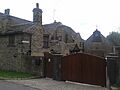
Beauchief Abbey House
-
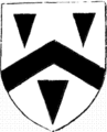
Pegge Family Arms


