Mayville, North Dakota facts for kids
Quick facts for kids
Mayville, North Dakota
|
|
|---|---|

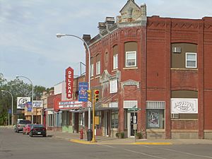
Downtown Mayville
|
|

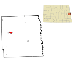
Location of Mayville, North Dakota
|
|
| Country | United States |
| State | North Dakota |
| County | Traill |
| Founded | 1881 |
| Area | |
| • Total | 1.88 sq mi (4.88 km2) |
| • Land | 1.88 sq mi (4.88 km2) |
| • Water | 0.00 sq mi (0.00 km2) |
| Elevation | 951 ft (290 m) |
| Population
(2020)
|
|
| • Total | 1,854 |
| • Estimate
(2022)
|
1,820 |
| • Density | 984.08/sq mi (380.00/km2) |
| Time zone | UTC-6 (Central (CST)) |
| • Summer (DST) | UTC-5 (CDT) |
| ZIP code |
58257
|
| Area code(s) | 701 |
| FIPS code | 38-51500 |
| GNIS feature ID | 1036155 |
| Highways | ND 18, ND 200 |
Mayville is a city in Traill County, North Dakota, in the United States. In 2020, about 1,854 people lived there. This makes Mayville the biggest town in Traill County.
The city started in 1881. It was named after May Arnold, who was the first child born to white settlers in that area. Mayville is often linked with its neighbor, Portland. People sometimes call them "May-Port." Mayville State University is also in Mayville.
Contents
Geography and Landscape
Mayville is in the rich Red River Valley, next to the Goose River. This valley was once covered by a huge glacier and a giant lake called Lake Agassiz. When the glacier melted, it left the land very flat and full of good soil. This makes the area around Mayville perfect for farming.
The United States Census Bureau says that Mayville covers about 1.92 square miles (4.97 square kilometers). All of this area is land.
People Living in Mayville
| Historical population | |||
|---|---|---|---|
| Census | Pop. | %± | |
| 1890 | 657 | — | |
| 1900 | 1,106 | 68.3% | |
| 1910 | 1,070 | −3.3% | |
| 1920 | 1,218 | 13.8% | |
| 1930 | 1,199 | −1.6% | |
| 1940 | 1,351 | 12.7% | |
| 1950 | 1,790 | 32.5% | |
| 1960 | 2,168 | 21.1% | |
| 1970 | 2,554 | 17.8% | |
| 1980 | 2,255 | −11.7% | |
| 1990 | 2,092 | −7.2% | |
| 2000 | 1,953 | −6.6% | |
| 2010 | 1,858 | −4.9% | |
| 2020 | 1,854 | −0.2% | |
| 2022 (est.) | 1,820 | −2.0% | |
| U.S. Decennial Census 2020 Census |
|||
Mayville's Population in 2010
In 2010, a census showed that 1,858 people lived in Mayville. There were 773 households, and 384 of these were families. The city had about 967.7 people per square mile (373.6 people per square kilometer).
Most people in Mayville were White (94.2%). A smaller number were African American (1.8%), Native American (0.6%), or Asian (0.2%). Some people were from other races or had mixed backgrounds. About 2.0% of the population was Hispanic or Latino.
In the households, 19.3% had children under 18. About 41.4% were married couples. Most households (50.3%) were not families. Many people (39.2%) lived alone, and 17.8% of those were 65 or older. The average household had 2.03 people, and the average family had 2.74 people.
The average age in Mayville was 37.9 years. About 15.3% of residents were under 18. A large group (23.2%) was between 18 and 24, likely due to the university. The city had slightly more females (51.2%) than males (48.8%).
Getting Around Mayville
Mayville's Airport
The Mayville Municipal Airport is owned by the city. It is open for public use. The airport is located about one nautical mile (2 km) south of Mayville's main downtown area.
Learning and Schools
Mayville is home to Mayville State University. This is a place where students can go to college.
The city is also part of the May-Port CG Public Schools system. "May-Port CG" stands for Mayville, Portland, Clifford, and Galesburg. This school system has Peter Boe Jr. Elementary School, May-Port CG Middle School, and May-Port CG High School.
Fun and Recreation
Mayville has several parks for people to enjoy. The biggest park is called Island Park.
The MayPort Community Center opened in 2000. It is a great place for hockey games and other community events. The Mayville Water Park opened in 2002. It has one of the largest water slides in the area. Mayville also has a 9-hole golf course called the Mayville Golf Club.
Mayville Media
Radio Stations
Mayville has a few radio stations:
FM radio:
- KMAV 105.5 "The Red River Valley's Sports Play-by-Play Leader" (Plays Country, Sports, and Pop music)
AM radio:
- KMSR 1520 "Sports Radio 1520" (Plays Sports programs)
Famous People from Mayville
Many notable people have connections to Mayville:
- Clarence Norman Brunsdale (1891–1978): He was a U.S. Senator and the 24th Governor of North Dakota.
- Gulbrand Hagen (1864–1919): A well-known newspaper editor and publisher.
- Ben Jacobson: He is a head coach for men's basketball at the University of Northern Iowa.
- RaeAnn Kelsch: A politician from North Dakota.
- Dean Knudson: A politician from Wisconsin.
- Jim LeClair: A football coach and player.
- Lute Olson: A famous former coach for the University of Arizona in College Basketball Hall of Fame.
Mayville's Climate
Mayville has a humid continental climate. This means it has big changes in temperature throughout the year. Summers are warm to hot and often humid. Winters are cold, sometimes very cold. On climate maps, this type of climate is called "Dfb" by the Köppen Climate Classification system.
| Climate data for Mayville, North Dakota (1991–2020 normals, extremes 1893–present) | |||||||||||||
|---|---|---|---|---|---|---|---|---|---|---|---|---|---|
| Month | Jan | Feb | Mar | Apr | May | Jun | Jul | Aug | Sep | Oct | Nov | Dec | Year |
| Record high °F (°C) | 56 (13) |
60 (16) |
81 (27) |
99 (37) |
104 (40) |
105 (41) |
114 (46) |
104 (40) |
102 (39) |
94 (34) |
79 (26) |
57 (14) |
114 (46) |
| Mean daily maximum °F (°C) | 16.1 (−8.8) |
21.0 (−6.1) |
33.4 (0.8) |
51.3 (10.7) |
66.6 (19.2) |
76.2 (24.6) |
80.1 (26.7) |
79.2 (26.2) |
70.1 (21.2) |
54.4 (12.4) |
36.3 (2.4) |
22.3 (−5.4) |
50.6 (10.3) |
| Daily mean °F (°C) | 6.2 (−14.3) |
10.3 (−12.1) |
23.2 (−4.9) |
39.7 (4.3) |
53.6 (12.0) |
64.7 (18.2) |
68.4 (20.2) |
66.5 (19.2) |
57.2 (14.0) |
43.1 (6.2) |
26.8 (−2.9) |
13.4 (−10.3) |
39.4 (4.1) |
| Mean daily minimum °F (°C) | −3.7 (−19.8) |
−0.5 (−18.1) |
13.0 (−10.6) |
28.0 (−2.2) |
40.6 (4.8) |
53.2 (11.8) |
56.6 (13.7) |
53.9 (12.2) |
44.2 (6.8) |
31.7 (−0.2) |
17.3 (−8.2) |
4.5 (−15.3) |
28.2 (−2.1) |
| Record low °F (°C) | −41 (−41) |
−40 (−40) |
−32 (−36) |
−9 (−23) |
11 (−12) |
21 (−6) |
26 (−3) |
30 (−1) |
15 (−9) |
−9 (−23) |
−30 (−34) |
−36 (−38) |
−41 (−41) |
| Average precipitation inches (mm) | 0.54 (14) |
0.53 (13) |
0.96 (24) |
1.50 (38) |
3.29 (84) |
4.11 (104) |
3.88 (99) |
2.66 (68) |
2.68 (68) |
2.11 (54) |
0.79 (20) |
0.85 (22) |
23.90 (607) |
| Average precipitation days (≥ 0.01 in) | 4.9 | 5.8 | 5.7 | 6.8 | 11.7 | 13.1 | 9.5 | 8.7 | 8.1 | 8.4 | 4.9 | 7.2 | 94.8 |
| Source: NOAA | |||||||||||||
See also
 In Spanish: Mayville (Dakota del Norte) para niños
 | Charles R. Drew |
 | Benjamin Banneker |
 | Jane C. Wright |
 | Roger Arliner Young |

