Mills County, Iowa facts for kids
Quick facts for kids
Mills County
|
|
|---|---|

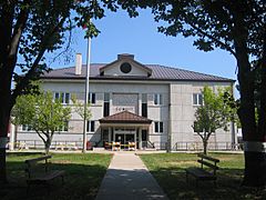
Mills County Courthouse
|
|

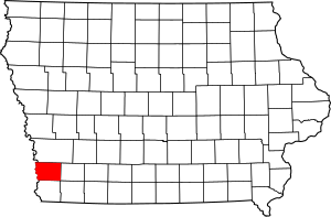
Location within the U.S. state of Iowa
|
|
 Iowa's location within the U.S. |
|
| Country | |
| State | |
| Founded | 1851 |
| Seat | Glenwood |
| Largest city | Glenwood |
| Area | |
| • Total | 441 sq mi (1,140 km2) |
| • Land | 437 sq mi (1,130 km2) |
| • Water | 3.2 sq mi (8 km2) 0.7% |
| Population
(2020)
|
|
| • Total | 14,484 |
| • Density | 32.84/sq mi (12.681/km2) |
| Time zone | UTC−6 (Central) |
| • Summer (DST) | UTC−5 (CDT) |
| Congressional district | 3rd |
Mills County is a county located in the U.S. state of Iowa. In 2020, about 14,484 people lived there. The main town, or county seat, is Glenwood.
The county was started in 1851. It was named after Major Frederick Mills. He was a soldier from Burlington, Iowa. Major Mills died in a battle during the Mexican–American War.
Mills County is part of a larger area. This area includes Omaha, Nebraska, and Council Bluffs, Iowa. It is called the Metropolitan Statistical Area.
Contents
History of Mills County
The first people to settle permanently in what would become Mills County arrived in 1846. They were members of the Church of Jesus Christ of Latter-day Saints. They had to leave their homes in Nauvoo, Illinois. This first settlement was called Rushville.
Another nearby settlement was also started by these settlers. It was called Coonsville, named after Dr. Liberius Coons. He was one of the first people to arrive. After the settlers moved on, Coonsville continued to grow. Its name was changed to Glenwood in 1853.
The Courthouses of Glenwood
In Glenwood, the first building used as a courthouse was small. It was made of wood and served until 1857. A new, two-story building replaced it. This building was made bigger in the 1900s. A clock tower was added in 1910.
In 1959, this older building was replaced. The current courthouse was officially opened on August 29, 1959.
Geography of Mills County
Mills County covers a total area of about 441 square miles. Most of this area, about 437 square miles, is land. The remaining 3.2 square miles, or 0.7%, is water.
Main Roads
Several important roads pass through Mills County:
Neighboring Counties
Mills County shares its borders with several other counties:
- Pottawattamie County, Iowa (to the north)
- Montgomery County, Iowa (to the east)
- Fremont County, Iowa (to the south)
- Cass County, Nebraska (to the southwest)
- Sarpy County, Nebraska (to the west)
Population of Mills County
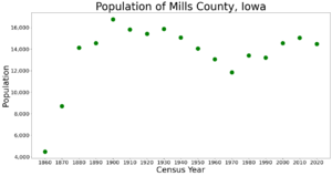
The population of Mills County has changed over time. Here's a look at how many people have lived there during different census years:
- 1860: 4,481 people
- 1870: 8,718 people
- 1880: 14,137 people
- 1890: 14,548 people
- 1900: 16,764 people
- 1910: 15,811 people
- 1920: 15,422 people
- 1930: 15,866 people
- 1940: 15,064 people
- 1950: 14,064 people
- 1960: 13,050 people
- 1970: 11,832 people
- 1980: 13,406 people
- 1990: 13,202 people
- 2000: 14,547 people
- 2010: 15,059 people
- 2020: 14,484 people
What the 2020 Census Shows
In 2020, the county had 14,484 people. This means there were about 33 people living in each square mile. Most people (95.16%) reported being of one race. About 90.05% were non-Hispanic White. Other groups included Black, Hispanic, Native American, Asian, and Native Hawaiian or Pacific Islander people. Some people reported being of more than one race.
There were 6,110 places to live (housing units). About 5,512 of these were occupied by people.
Towns and Areas
Mills County has several cities, one special census-designated place, and unincorporated communities. It also has different areas called townships.
Cities in Mills County
- Emerson
- Glenwood
- Hastings
- Henderson
- Malvern
- Pacific Junction
- Silver City
- Tabor (partly in another county)
Unincorporated Communities
- Rushville
Census-Designated Place
Townships
- Anderson
- Center
- Deer Creek
- Glenwood
- Indian Creek
- Ingraham
- Lyons
- Oak
- Plattville
- Rawles
- St. Marys
- Silver Creek
- White Cloud
Largest Communities by Population (2020 Census)
The following table shows the largest communities in Mills County based on the 2020 census.
| Rank | Community | Type | Population (2020) |
|---|---|---|---|
| 1 | † Glenwood | City | 5,073 |
| 2 | Malvern | City | 1,046 |
| 3 | Emerson | City | 403 |
| 4 | Silver City | City | 245 |
| 5 | Mineola | CDP | 154 |
† county seat
Law Enforcement
The first sheriff of Mills County was W.W. Noyes. He was chosen on August 1, 1851. James Hardy became the first elected sheriff. He started his job on August 31, 1851.
Today, the sheriff of Mills County is interim sheriff Joshua England. He and his 11 full-time deputies help keep the county safe. They patrol about 447 square miles. The Mills County Sheriff's Office provides police help for all the towns and cities in Mills County. The only exception is the City of Glenwood, which has its own police department.
See also
 In Spanish: Condado de Mills (Iowa) para niños


