Mission Point (California) facts for kids
Quick facts for kids Mission Point |
|
|---|---|

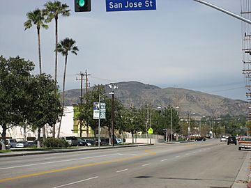
Mission Point, from Zelzah Ave. and San Jose St.
|
|
| Highest point | |
| Elevation | 2,771 ft (845 m) NAVD 88 |
| Prominence | 184 ft (56 m) |
| Geography | |
| Location | Los Angeles County, California, U.S. |
| Parent range | Santa Susana Mountains |
| Topo map | USGS Oat Mountain |
| Climbing | |
| Easiest route | Trail |
Mission Point, often called "Mission Peak" by people who live nearby, is a part of Oat Mountain in Los Angeles County, Southern California. It stands tall at 2,771 feet (845 meters). This makes it the second highest point in the Santa Susana Mountains, right after Oat Mountain itself.
Contents
Exploring Mission Point's Location
Mission Point is found on the eastern edge of the Santa Susana Mountains. To its east is Newhall Pass. This pass is like a natural border, separating the Santa Susana and San Gabriel mountain ranges. Mission Point sits above Aliso Canyon. It is located north of California State Route 118, which is also known as the Ronald Reagan Freeway. You can find it between Porter Ranch and Granada Hills in the San Fernando Valley.
Fun Activities at Mission Point
This area is a great spot for outdoor fun! Many people enjoy hiking and mountain biking here. The view from the top of Mission Point is amazing. You can see most of the San Fernando Valley spread out below. On a clear day, you might even spot the Pacific Ocean and Downtown Los Angeles.
At the very top, there is a special monument. It is dedicated to Mario A. DeCampos M.D. (born May 26, 1924, died February 17, 1984). The monument has a kind message carved into it:
- "Share this peaceful retreat and enjoy the beauty.—Mario's Friends 5/26/1984"
Trails to the Top
There are at least two main paths to reach Mission Point. One trail starts at the far end of O'Melveny Park. You just keep going until the path splits, then take the trail that goes uphill.
Another way to get there is from the end of Neon Way. This is a residential street. As you start this trail, look for a small pond with live goldfish to your east. Near the beginning of this trail, you will also see a gas line going up to Mission Point. If you are looking for a real challenge, you can even hike directly up alongside this gas line.
Trail Updates and Open Space
As of October 2007, the Southern California Gas Company has put up gates in some areas near the top of Mission Point. However, you can still reach the peak using a new trail that was created. The area northeast of Mission Point is part of a large natural space. It is called the Michael D. Antonovich Open Space Preserve. This preserve covers 500 acres and was officially opened on August 12, 2002.
See also
 In Spanish: Mission Point (California) para niños

