
Mohotani facts for kids

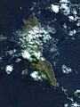
Moho Tani viewed from space
|
|

Location of Mohotani within the Marquesas Islands
|
|
| Geography | |
|---|---|
| Location | South Pacific Ocean |
| Coordinates | 9°59′02″S 138°49′47″W / 9.9838°S 138.8296°W |
| Archipelago | Marquesas Islands |
| Area | 15 km2 (5.8 sq mi) |
| Administration | |
| Overseas country | French Polynesia |
Mohotani (sometimes spelled Moho Tani; also called Molopu or Motane) is an island in the southern Marquesas Islands. It is not currently inhabited by people. You can find it southeast of Hiva Oa and east of Tahuata.
The island covers an area of 15 square kilometers. Sadly, many wild goats and sheep have eaten most of the plants on the island. Because of this, when it rains, the soil washes into the sea, turning the water around the island red. Long ago, people said the island was very fertile, with lots of forests and fields. When explorer Thor Heyerdahl visited in 1938, he only saw a few goats and the remains of old, empty huts and villages.
Mohotani is managed as part of the commune (or municipality) of Hiva-Oa. This area is part of French Polynesia, which is an overseas country of France.
It is believed that a group of people called the "Moi a Tiu" once lived on Mohotani. However, they were sadly wiped out by sickness and wars. The few people who survived left the island and moved to Hiva ʻOa. Before Europeans arrived, the island was considered part of the Pepane area.
In 1992, Mohotani and its smaller surrounding islands, like Terihi, became officially protected. They were declared the Motane Nature Reserve to help save their unique plants and animals.
Contents
History
Before Europeans arrived, the Moi a Tiu tribe lived on Mohotani. It was the smallest island in the archipelago that had people living on it. Sadly, many people died from fighting and diseases brought by foreign sailors. The few who survived eventually left the island and went to Hiva Oa.
Even though Mohotani is empty today, there is clear proof that Polynesian people once lived there permanently. An American expert named Ralph Linton found the remains of an old settlement. Thor Heyerdahl also found several stone house platforms (called paepae) in the dry eastern part of the island during a short visit in 1938. The island was home to just one group, the "Moi-Atiu," who were related to a tribe from Hiva Oa.
Europeans first saw Mohotani in 1595. The Spanish explorer Álvaro de Mendaña de Neira discovered it during his second trip to Europe. He did not land on the island but named it "San Pedro." This name honored Saint Simon Peter and also referred to his captain, Pedro Fernandes de Queirós. Mendana said the island was "covered with much forest" and saw no signs of people living there.
James Cook sailed past Mohotani on April 7, 1774, during his second trip to the Pacific. He passed between Hiva Oa and Mohotani but did not go onto Mohotani. He described the island like this:
"San Pedro [Mohotani] is rather high, but not mountainous, and is about 3 leagues in circumference. [The island] lies 4 ½ Leagues south of the eastern point of La Dominica [Hiva Oa] and we do not know whether it is inhabited or not, probably not, however, as nature does not seem to have endowed it with anything that men require."
—James Cook
On a map drawn by William Wales, an astronomer on Cook's ship, Mohotani was called "Onateayo." This was probably the name given to it by the people of Hiva Oa.
In 1992, Mohotani was officially named the "Motane Island Nature Reserve" (réserve naturelle de l'île de Motane). This was done to protect its special environment. The reserve also includes the small island of Terihi. Terihi is home to many seabirds like gannets, terns, and frigate birds.
Geography
Mohotani is located about 17 kilometers south and southeast of Hiva Oa. It is also 21 kilometers east of Tahuata and 47 kilometers north of Fatu Iva. The island is 15 square kilometers in size. It forms a shape like an open crescent moon, facing east. It is about 8 kilometers long from north to south and about 2 kilometers wide from east to west.

It is a high island. Its highest point is 520 meters in the south. The overall shape of the island looks a bit like the back of a whale.
Terihi Islet
About 300 meters to the southeast of Mohotani is Terihi. This is a rocky islet that is 0.150 square kilometers in size. It has very steep coastlines and a total edge of 3.4 kilometers. Terihi is part of the same group of volcanoes as Mohotani. It rises 245 meters above the sea.
The plants on Terihi are few. They mainly include a tough grass called Eragrostis xerophila. There is also a slow-growing plant called Nicotiana fragrans var Fatuhivensis. This plant is a type of nightshade and is found only on Fatu Hiva and Mohotani.
Geology of the Island
Mohotani is actually the west-southwestern part of a collapsed volcano. This volcano was once much larger, about ten kilometers across. It formed millions of years ago because of a "hot spot" deep in the Earth.
The island was created in two stages. The most recent stage happened about 2.2 million years ago. Mohotani is mostly made of a type of rock called basalt.
Flora and Fauna
Mohotani has been a protected area since 1971. Hunting is allowed only with a special permit. However, because the island is far away, some people visit without permission. Also, trees are sometimes cut down illegally to get wood for making souvenirs. There is still a need for better management and monitoring of this protected area.
Sheep were brought to the island by French settlers from Hiva Oa in the late 1800s. These sheep have multiplied greatly and now roam freely. They eat the low-growing plants, which causes the soil to wash away easily.
Plant Life
Mohotani has three main areas of plant life. The eastern part is very dry and has few plants. The northern part also has little vegetation. However, the west-central part of the island is covered by a thick forest that is mostly untouched.
The entire eastern side is dry because animals eat most of the plants. The plant cover is thin. In good spots, you can find Nicotiana fragrans var. fatuhivensis, which is a type of tobacco plant found only on Fatu Hiva and Mohotani. You can also find purslane (Portulaca oleracea) and grasses like Eragrostis xerophila and Brachiaria reptans.
The northern part of the island is also badly damaged by animals eating the plants. Evergreen shrubs like Arbutilon hirtum, Cordia lutea, and Waltheria tomentosa grow there as low bushes. Pisonia grandis, Premna tahitensis, and Morinda citrifolia also grow in the few places animals cannot reach.
The central plateau, in the west, has a thick forest. This forest covers about a quarter of the island. It has huge Pisonia grandis trees, which often grow 30 to 40 meters tall. Other common trees include Cordia subcordata, Thespesia populnea, Hibiscus tiliaceus, Pandanus tectorius, Ficus marcuesensis, Casuarina equisetifolia, and some coconut trees.

Animal Life
There are only two types of mammals on Mohotani, and neither of them are native to the island. One is the Pacific rat, which was probably brought by Polynesians as a food source. The other is sheep, which Europeans brought in the 1800s.
Scientists have seen ten types of seabirds and seven types of land birds on Mohotani. Two of the land bird species are endemic, meaning they are found nowhere else in the world.
Frigatebirds build their nests in the large Pisonia trees. Other seabirds found on Mohotani and Terihi include noddi (Anous stolidus), sooty tern (Sterna fuscata), and fairy tern (Gygis alba).
Among the land birds, the Marquesas monarch (a type of bird called Pomarea mendozae montanensis) and Acrocephalus caffer consobrinus (a type of long-billed warbler) are endemic. Other rare and endangered birds include the Marquesas warbler (Acrocephalus mendanae), the Marquesas salangana (Aerodramus ocistus), and the Petit-Thouars fruit pigeon (Ptilinopus dupetithouarsii).
See also
 In Spanish: Moho Tani para niños
- Terihi
- Desert island
- List of islands
Images for kids
-
Moho Tani viewed from space
-

Location of Mohotani within the Marquesas Islands
-
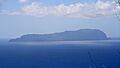
View of the island from Hiva Oa
-
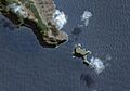
Terihi Islet
