
Moira River facts for kids
Quick facts for kids Moira River |
|
|---|---|

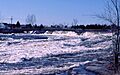
Moira River on a warm afternoon
|
|

Location of the mouth of the Moira River in southern Ontario.
|
|
| Country | Canada |
| Province | Ontario |
| Region | Central Ontario |
| County | Hastings |
| Physical characteristics | |
| Main source | unnamed lake Tudor and Cashel 303 m (994 ft) 44°49′49″N 77°33′40″W / 44.83028°N 77.56111°W |
| River mouth | Bay of Quinte Belleville 74.1 m (243 ft) 44°09′36″N 77°23′02″W / 44.16000°N 77.38389°W |
| Length | 98 km (61 mi) |
| Basin features | |
| River system | Lake Ontario drainage basin |
| Tributaries |
|
The Moira River is a river located in Hastings County in eastern Ontario, Canada. It flows from its starting point in the middle of the county. The river ends its journey at the Bay of Quinte, which is located near Belleville, the main town of the county.
Contents
River's Name
The local Indigenous peoples first called this river the Sagonaska River. In 1807, the British government in charge of the area (called Upper Canada at the time) changed its name. They renamed it after Francis Rawdon-Hastings, who was also known as the Earl of Moira.
Francis Rawdon-Hastings was a British soldier and politician. He fought in the American Revolutionary War. Even though the river was named after him, he had no direct connection to the area. The name Sagonaska is still used in the Belleville area today. For example, a bridge over the Moira River and a local school are both named Sagonaska.
River's Journey
The Moira River starts in an unnamed lake in a northern part of Tudor and Cashel. This starting point is about 303 meters (994 feet) above sea level.
Flowing South
- The river flows south into the area of Madoc.
- It passes through Wolf Lake, which is about 276 meters (906 feet) above sea level.
- The river goes under Highway 62.
- Near the small town of Bannockburn, it is joined by the Jordan River, which flows in from the right side.
- The Moira River then continues its path south.
Twists and Turns
- The river makes a big loop, going east and then back west. It passes under Highway 62 again at Keller Bridge.
- It keeps flowing south, staying to the west of Eldorado.
- The river then takes a sharp turn to the west.
- At Malone, in the area of Marmora and Lake, it is joined by Gawley Creek, another river flowing in from the right.
- The Moira River then turns south again.
Through Lakes and Dams
- It flows through Deloro Lake and over the Deloro Dam in Deloro. Here, the elevation is about 200 meters (656 feet).
- The river crosses under Highway 7.
- The Moira then heads east and enters the area of Stirling-Rawdon.
- It flows into Bend Bay on Moira Lake, which is about 154 meters (505 feet) above sea level. This is south of the community of Madoc.
- At Moira Lake, it is joined by Madoc Creek, which flows in from the left.
Continuing East and South
- The river continues east from Moira Lake.
- It enters the area of Tweed.
- Here, it is joined by two rivers from the left: the Black River and the Skootamatta River.
- The Moira River then flows south through the village of Tweed, Ontario.
- It enters Stoco Lake, which is about 138 meters (453 feet) above sea level.
- At Stoco Lake, it is joined by Sulphide Creek and Clare River, both from the left.
Final Stretch to the Bay
- The river leaves Stoco Lake through two channels. One is called Moira River, and the other is the West Channel. These channels go around Sugar Island.
- It flows southwest and runs alongside Highway 37 all the way to Belleville.
- The river flows through the northwest corner of Tyendinaga.
- It then enters the city of Belleville and continues southeast.
- In Belleville, it is joined by Chrysal Creek and Palliser Creek, both from the right.
- The Moira River flows over several dams, including the Belleville Yardmen Dam, the former Laziers Dam Site, the McLeod Dam, and the Lott Dam.
- Finally, the Moira River reaches its end at the Bay of Quinte, which is part of Lake Ontario.
River's Watershed
A river's watershed is all the land area where water drains into that river and its smaller streams. While the Moira River itself is completely within Hastings County, its watershed is much larger. It includes parts of two counties to the east: Lennox and Addington and Frontenac.
- Some parts of the Clare River, which flows into the Moira, extend into Central Frontenac in Frontenac County.
- The Clare River also flows through Stone Mills and Addington Highlands in Lennox and Addington County.
- The Skootamatta River and its smaller streams also flow through Addington Highlands.
- The smaller streams that feed the Moira River also reach further north in Hastings County than the main river itself. For example, Partridge Creek, which is part of the Skootamatta system, goes past Upper Partridge Lake. It reaches as far north as 44° 57′ 28″ North in the Cashel part of Tudor and Cashel.
Rivers Joining the Moira
Here are the main streams and rivers that flow into the Moira River:
- Palliser Creek (joins from the right)
- Chrysal Creek (joins from the right)
- Clare River (joins from the left)
- Sulphide Creek (joins from the left)
- Skootamatta River (joins from the left)
- Black River (joins from the left)
- Madoc Creek (joins from the left)
- Gawley Creek (joins from the right)
- Jordan River (joins from the right)
Images for kids
-
Spring run-off on the Moira River, March 1975

