Skootamatta River facts for kids
Quick facts for kids Skootamatta River |
|
|---|---|

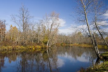
The Skootamatta River at the picnic area at Highway 7 & Highway 37 in fall
|
|
|
Location of the mouth of the Skootamatta River in southern Ontario
|
|
| Country | Canada |
| Province | Ontario |
| Region | |
| Counties |
|
| Physical characteristics | |
| Main source | Joeperry Lake Addington Highlands, Lennox and Addington County 315 m (1,033 ft) 44°48′07″N 77°13′21″W / 44.80194°N 77.22250°W |
| River mouth | Moira River Tweed, Hastings County 152 m (499 ft) 44°31′09″N 77°20′23″W / 44.51917°N 77.33972°W |
| Length | 74.1 km (46.0 mi) |
| Basin features | |
| River system | Great Lakes Basin |
| Tributaries |
|
The Skootamatta River is a river in Ontario, Canada. It flows through Hastings County and Lennox and Addington County. This river starts at Joeperry Lake and joins the Moira River in a town called Tweed. The name "Skootamatta" likely comes from the Ojibwe language, meaning "burnt shoreline."
Contents
Journey of the Skootamatta River
The Skootamatta River begins its journey at Joeperry Lake. This lake is located in Bon Echo Provincial Park in Addington Highlands, Ontario. The starting point is northwest of Cloyne, Ontario, at an elevation of about 315 meters (1,033 feet).
Flowing South: Lakes and Creeks
As the river flows south, it meets Rainy Creek. Then, it reaches Pearson Lake. The river continues its southward path and empties into Skootamatta Lake. Here, the river is at an elevation of about 289 meters (948 feet). Another stream, Killer Creek, also joins the river at Skootamatta Lake.
The river then flows over the Skootamatta Dam. It continues south and reaches Slave Lake, which is at an elevation of about 277 meters (909 feet). After Slave Lake, the river flows over another small dam. It then takes in Partridge Creek before reaching the community of Flinton.
Through Flinton and Towards the Moira River
In Flinton, the Skootamatta River flows over the Flinton Dam. It then heads southwest and enters Hastings County. Here, Flinton Creek joins the river from the left side. This meeting point is at an elevation of about 188 meters (617 feet).
The river keeps flowing south and takes in Little Skootamatta Creek. This happens at an elevation of about 179 meters (587 feet). The Skootamatta River then turns west, just north of Highway 7.
Finally, Elzevir Creek joins the river. The Skootamatta River then flows under Highway 7 near Actinolite. It runs alongside Highway 37 for a bit. The river's journey ends when it meets the Moira River. This meeting point is at an elevation of about 152 meters (499 feet). The Moira River then flows into the Bay of Quinte on Lake Ontario.
River's Past: Logging and Power
For many years, until 1908, the Skootamatta River was important for moving logs. These logs were floated down the river to sawmills located in the Belleville area.
At one time, there was a small hydroelectric power station on the river. This station was near Slave Lake. It generated electricity for a nearby gold mine, helping it to operate.
Streams Joining the Skootamatta
Many smaller streams and lakes connect to the Skootamatta River. These are called tributaries. They add water to the main river as it flows.
- Elzevir Creek
- Little Skootamatta Creek (joins from the left)
- Flinton Creek (joins from the left)
- Partridge Creek (joins from the right)
- Skootamatta Lake
- Killer Creek (joins Skootamatta Lake)
- Rainy Creek (joins from the right)
Towns Along the River
The Skootamatta River flows near or through a few communities:
- Flinton, Ontario
- Actinolite, Ontario
Skootamatta in Culture
The Skootamatta River is mentioned in a famous book called The English Patient by Michael Ondaatje. In the novel, one of the main characters, Hana, once lived near this river. The river is also the name of a song by the band Summerhouse, from Cobourg, Ontario, on their CD "Summerhouse... In Black."
 | Janet Taylor Pickett |
 | Synthia Saint James |
 | Howardena Pindell |
 | Faith Ringgold |


