Monongahela, Pennsylvania facts for kids
Quick facts for kids
Monongahela, Pennsylvania
|
|
|---|---|

|
|
| Nickname(s):
Mon City
|
|

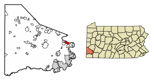
Location of Monongahela in Washington County, Pennsylvania.
|
|
| Country | United States |
| State | Pennsylvania |
| County | Washington |
| Established | 1770 |
| Area | |
| • Total | 2.09 sq mi (5.40 km2) |
| • Land | 1.91 sq mi (4.95 km2) |
| • Water | 0.17 sq mi (0.45 km2) |
| Elevation | 755 ft (230 m) |
| Population
(2020)
|
|
| • Total | 4,159 |
| • Density | 2,174.07/sq mi (839.43/km2) |
| Time zone | UTC-5 (Eastern (EST)) |
| • Summer (DST) | UTC-4 (EDT) |
| ZIP Code |
15063
|
| Area code(s) | 724 |
| FIPS code | 42-50408 |
Monongahela, often called Mon City by locals, is a city in Washington County, Pennsylvania, United States. In 2020, about 4,149 people lived there. It is part of the Pittsburgh metropolitan area, located about 17 miles (27 km) south of Pittsburgh.
The city is a meeting point for several important Pennsylvania state routes. Routes 88, 136, and 837 run along Main Street. Route 481 ends at Main Street on Park Avenue.
Monongahela is one of only two cities in Washington County. It is also the second smallest city in Pennsylvania. The Ringgold School District serves the town's students.
Contents
History of Monongahela
Monongahela was founded in 1769. It is located near where Pigeon Creek flows into the Monongahela River. This makes it the oldest settlement in the Monongahela River Valley. It is likely the oldest in Washington County too. The name "Monongahela" comes from a Native American word meaning "falling banks". The Monongahela tribe lived in this area before the city was settled.
The land was first owned by three different men. They named their parts Eden, Paradise, and Gloucester. Joseph Parkison, who ran a ferry across the Monongahela River, is known as the city's founder. He built the first post office. In 1782, the town was called Parkison's Ferry. Later, in 1807, Adam Wickerham created a town called Georgetown on part of this land. Georgetown became part of Williamsport in 1816. In 1833, Williamsport elected its first local leaders. On April 1, 1837, Williamsport was renamed Monongahela City. In 1893, its name was shortened to Monongahela.
Many streets in the city are named after important figures from the American Civil War. These include Lincoln, Grant, Sherman, and Sheridan.
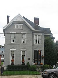
Several historic places in Monongahela are listed on the National Register of Historic Places. These include the Edward G. Acheson House, the Bethel African Methodist Episcopal Church of Monongahela City, the David Longwell House, and the Monongahela Cemetery.
Geography and Climate
Monongahela is located at 40°12′2″N 79°55′42″W / 40.20056°N 79.92833°W.
The city covers a total area of about 2.1 square miles (5.4 square kilometers). Most of this area is land, about 1.9 square miles (4.9 square kilometers). The rest, about 0.2 square miles (0.5 square kilometers), is water.
Monongahela gets about 37.65 inches (956 mm) of rain each year. The average yearly temperature is about 63°F (17°C).
Neighboring Areas
Monongahela shares land borders with two places. Carroll Township is to its east and south. New Eagle is to its west. Across the Monongahela River, Forward Township in Allegheny County is next to the city.
Population Information
| Historical population | |||
|---|---|---|---|
| Census | Pop. | %± | |
| 1840 | 752 | — | |
| 1850 | 977 | 29.9% | |
| 1860 | 999 | 2.3% | |
| 1870 | 1,078 | 7.9% | |
| 1880 | 2,904 | 169.4% | |
| 1890 | 4,096 | 41.0% | |
| 1900 | 5,173 | 26.3% | |
| 1910 | 7,598 | 46.9% | |
| 1920 | 8,688 | 14.3% | |
| 1930 | 8,675 | −0.1% | |
| 1940 | 8,825 | 1.7% | |
| 1950 | 8,922 | 1.1% | |
| 1960 | 8,388 | −6.0% | |
| 1970 | 7,113 | −15.2% | |
| 1980 | 5,950 | −16.4% | |
| 1990 | 4,928 | −17.2% | |
| 2000 | 4,761 | −3.4% | |
| 2010 | 4,300 | −9.7% | |
| 2020 | 4,149 | −3.5% | |
| 2021 (est.) | 4,121 | −4.2% | |
| Sources: | |||
In 2000, there were 4,761 people living in Monongahela. There were 2,139 households and 1,264 families. The population density was about 2,472 people per square mile (954 per square kilometer).
About 20.1% of the population was under 18 years old. About 23.0% were 65 years or older. The average age was 42 years. For every 100 females, there were about 85 males.
Culture and Community
Monongahela has several parks, playgrounds, and a museum. Chess Park, in the city center, hosts many community events. The Mounds Park is a local playground and sports area. It is built on an ancient Native American burial ground. The Aquatorium is a waterfront spot on the Monongahela River. It hosts the yearly Fourth of July celebration and summer concerts. The Monongahela Area Historical Society Museum keeps local historical items and records.
Whiskey Point is a high spot overlooking the Monongahela River. It was an important meeting place during the Whiskey Rebellion in 1794. A historical marker there explains that a speech by Albert Gallatin helped end the rebellion peacefully. Today, "Monongahela Rye" is a type of rye whiskey known for its spicy taste.
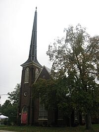
Many buildings in Monongahela, like the Longwell House and the Bethel A.M.E Church, were part of the Underground Railroad. They helped freed slaves find safety.
There are twenty churches in Monongahela, representing fifteen different types of faiths. The Church of Jesus Christ (Bickertonite) has its main worldwide office in Monongahela.
Park Avenue's Famous Residents
Park Avenue in Monongahela has been home to many famous people. NFL Hall of Fame quarterback Joe Montana grew up there.
Other notable residents include:
- Carl E. Vuono, a four-star general and former Chief of Staff of the U.S. Army.
- Jim Jimirro, who founded the Disney Channel.
- Fred Cox, a top scorer for the Minnesota Vikings and the inventor of the Nerf ball.
- Dr. Ronald V. Pellegrini, a famous heart surgeon.
- Dierdre Bair, who won a National Book Award.
- Ron Necciai, a former Pittsburgh Pirate pitcher. He is the only professional baseball player to strike out 27 batters in one game.
A documentary called "One Extraordinary Street" was made in 2008. It is about the notable people from Park Avenue. Laura M. Magone, a Monongahela native, produced the film. She interviewed many people to find out what made them so successful. The film also features Stan Musial and retired general Colin Powell.
Notable People
- Edward Goodrich Acheson, a chemist and inventor of Carborundum.
- Jay Chattaway, a composer known for his work on Star Trek.
- Fred Cox, former NFL kicker and inventor.
- Mitch Daniels, former Governor of Indiana.
- John Taylor Gatto, an educator and writer.
- Roland Kibbee, a screenwriter and producer.
- Joe Montana, former NFL quarterback.
- Eugenie Maria Morenus, a mathematician who graduated from Monongahela High School.
- Jackie Ormes, an American cartoonist.
- Anthony Peterson, former NFL linebacker.
- Jim Renacci, former U.S. representative.
- Carl E. Vuono, U.S. Army general.
- Scott Zolak, former NFL quarterback.
See also
 In Spanish: Monongahela (Pensilvania) para niños
 | Precious Adams |
 | Lauren Anderson |
 | Janet Collins |


