
Morning Star Peak facts for kids
Quick facts for kids Morning Star Peak |
|
|---|---|

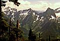
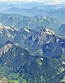
North aspect, from Dickerman
|
|
| Highest point | |
| Elevation | 6,020 ft (1,830 m) |
| Prominence | 980 ft (300 m) |
| Isolation | 0.98 mi (1.58 km) |
| Parent peak | Del Campo Peak (6,610 ft) |
| Geography | |

Morning Star Peak
Location in Washington (state)

Morning Star Peak
Location in the United States
|
|
| Location | Snohomish County, Washington, U.S. |
| Parent range | Cascade Range |
| Topo map | USGS Bedal |
| Climbing | |
| First ascent | 1940 by Sam Heller |
| Easiest route | class 3 scrambling |
Morning Star Peak is a mountain in Washington that stands about 6,020 feet (1,835 meters) tall. It's located in Snohomish County, near the western edge of the North Cascades mountain range.
This peak is about 2.5 miles (4 km) southwest of Barlow Pass. You can find it along the Mountain Loop Highway, close to the Monte Cristo area. The land around Morning Star Peak is part of the Mount Baker-Snoqualmie National Forest. The closest taller mountain is Sperry Peak, which is about 1 mile (1.6 km) to the northwest.
Water from the south side of the mountain flows into the Sultan River. Water from the north side goes into the beginnings of the Stillaguamish River. The best time to climb Morning Star Peak is usually from July through September. This is when the weather is most pleasant.
Mountain Weather: What to Expect
Morning Star Peak is in a "marine west coast" climate zone. This means it gets a lot of rain and snow. Most weather systems come from the Pacific Ocean and move towards the Cascade Range.
When these weather systems hit the tall Cascade Mountains, they are forced upwards. This causes them to drop their moisture as rain or snow. This process is called Orographic lift. Because of this, the western side of the North Cascades gets a lot of precipitation, especially heavy snowfall in winter.
Thanks to the ocean's influence, temperatures here rarely go below 0°F (-18°C) or above 80°F (27°C). Winters are often cloudy. However, during summer, high-pressure systems over the Pacific Ocean bring clear skies. The snow here tends to be wet and heavy. This can create a high risk of avalanches, so it's important to be careful.
How the Mountains Were Formed
The North Cascades are known for their rugged landscape. They have sharp peaks, long ridges, and deep valleys carved by glaciers. These amazing shapes and big changes in elevation were created by geological events over millions of years. These changes also led to different climates and types of plants in the area.
The Cascade Mountains started forming millions of years ago, during a time called the late Eocene Epoch. This happened because the North American Plate was slowly moving over the Pacific Plate. This movement caused a lot of volcanic activity. For example, Glacier Peak, a large volcano, began forming about 19 miles (31 km) east-northeast of Morning Star Peak.
About 50 million years ago, small pieces of the Earth's crust, called terranes, came together to form the North Cascades. Later, during the Pleistocene period (which started over two million years ago), glaciers repeatedly moved across the land. As they advanced and retreated, they scraped away rock and left behind debris. The U-shaped valleys you see in the rivers today are a result of these glaciers. The combination of land being pushed up (uplift) and cracks in the Earth's crust (faulting), along with glaciation, created the tall peaks and deep valleys of the North Cascades.
Images for kids
-
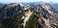
Morning Star front and center, from Del Campo Peak (behind are Vesper, Sperry, and Big Four)
-
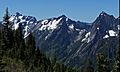
Del Campo, Morning Star, and Sperry
-
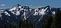
Del Campo and Morning Star
-
Morning Star centered
-
Aerial view, Morning Star left of center
.jpg)


