
Sperry Peak facts for kids
Quick facts for kids Sperry Peak |
|
|---|---|

Sperry Peak
|
|
| Highest point | |
| Elevation | 6,120 ft (1,870 m) |
| Prominence | 720 ft (220 m) |
| Geography | |

Sperry Peak
Location in Washington (state)

Sperry Peak
Location in the United States
|
|
| Parent range | North Cascades Cascade Range |
| Topo map | USGS Silverton |
| Geology | |
| Age of rock | 260 to 370 million years |
| Type of rock | metamorphosed sandstone shale, conglomerate |
| Climbing | |
| First ascent | 1927 by Norval Grigg and Art Winder |
| Easiest route | Scrambling Southwest slope |
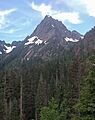
Sperry Peak is a mountain in Washington state, standing 6,120+ ft (1,870+ m) tall. It is located in Snohomish County, within the North Cascades mountain range. This peak is found near the Mountain Loop Highway and the Monte Cristo area.
Sperry Peak is part of the Mount Baker-Snoqualmie National Forest. Its closest taller neighbor is Vesper Peak, which is about 0.74 miles (1.19 km) to the west. A high ridge connects these two peaks. The mountain was named after A. D. (Dick) Sperry, who was a mining prospector in the 1890s. He worked near the town of Silverton. There is even a picnic area named after him near an old mine site.
Weather Patterns at Sperry Peak

Sperry Peak is in a marine west coast climate zone. This means it gets a lot of moisture from the Pacific Ocean. Most weather fronts, which are like big air masses, move from the Pacific Ocean towards the Cascade Mountains.
When these weather fronts hit the tall peaks of the Cascades, they are forced to rise. As the air rises, it cools down and drops its moisture. This process is called Orographic lift. It causes a lot of rain or snowfall on the western side of the North Cascades.
Because of the ocean's influence, the climate is mild. Temperatures rarely go below 0 °F (−18 °C) in winter or above 80 °F (27 °C) in summer. Winters are often cloudy with lots of snow. This snow tends to be wet and heavy, which can lead to a high risk of avalanches. Summers, however, are usually clear and sunny due to high pressure systems over the Pacific.
How Sperry Peak Was Formed

The North Cascades mountains, where Sperry Peak is located, have very rugged shapes. They feature sharp peaks, long ridges, and deep valleys carved by glaciers. These unique landforms were created by geological events that happened millions of years ago. These events caused big changes in elevation and led to different climates across the range.
The formation of the Cascade Mountains began millions of years ago. This was during the late Eocene Epoch. At that time, the North American Plate was slowly moving over the Pacific Plate. This movement caused many volcanic eruptions and rock formation.
About 50 million years ago, small pieces of the Earth's crust, called terranes, came together. These pieces of oceanic and continental lithosphere helped create the North Cascades.
Later, during the Pleistocene period, which started over two million years ago, glaciers played a huge role. These massive ice sheets moved back and forth many times. As they moved, they scraped and shaped the land. They left behind deposits of rock and debris. The "U"-shaped valleys you see today were formed by these glaciers.
The main forces that created the tall peaks and deep valleys of the North Cascades are uplift (when land rises) and faulting (when the Earth's crust breaks and moves), combined with the powerful action of glaciers.
Images for kids
-
Sperry Peak
