Mount Bachelor facts for kids
Quick facts for kids Mount Bachelor |
|
|---|---|

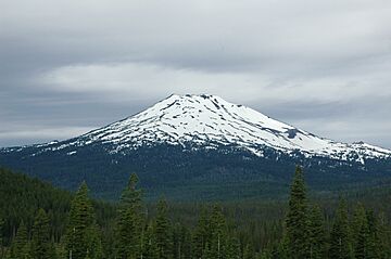
Mount Bachelor from the Cascade Lakes Scenic Byway (east of the mountain)
|
|
| Highest point | |
| Elevation | 9,068 ft (2,764 m) NAVD 88 |
| Geography | |
| Location | Deschutes County, Oregon, U.S. |
| Parent range | Cascade Range |
| Topo map | USGS Mount Bachelor |
| Geology | |
| Formed by | Subduction zone volcanism |
| Age of rock | Less than 15,000 years |
| Mountain type | Stratovolcano (on top of a shield volcano) |
| Volcanic arc | Cascade Volcanic Arc |
| Last eruption | 5800 BC |
| Climbing | |
| Easiest route | Ski lifts |
Mount Bachelor, once called Bachelor Butte, is a sleeping volcano in central Oregon, USA. It's part of the Cascade Range, a chain of mountains with many volcanoes. This mountain got its name because it stands alone, unlike the nearby Three Sisters volcanoes.
Mount Bachelor is a special type of volcano called a stratovolcano built on top of a shield volcano. It formed less than 15,000 years ago. Scientists think it's a "moderate threat," meaning it's unlikely to erupt soon. They are still figuring out if it's truly extinct (won't erupt again) or just dormant (sleeping).
Since 1958, the Mount Bachelor ski area has been a popular spot on the mountain. It's a great place for winter sports like alpine skiing, snowboarding, and cross-country skiing. You can even go dog sledding there! The very top of the mountain also has an observatory for studying the air.
Contents
Exploring Mount Bachelor's Location
Mount Bachelor is located in Deschutes County, Oregon, within the beautiful Cascade Range. It sits south of the Three Sisters volcanoes. The mountain is about 9,068 feet (2,764 meters) tall. It rises about 3,500 feet (1,067 meters) from its base.
The weather around Mount Bachelor can change a lot. This is because of something called a "rain shadow." Air from the Pacific Ocean brings moisture. As this air goes up the western side of the Cascade Mountains, it cools down and drops its moisture as rain or snow. By the time it reaches the eastern side, the air is much drier and warmer.
So, the western slopes get a lot of rain and snow, from 80 to 125 inches (203 to 318 cm) each year. But the eastern slopes, where Mount Bachelor is, get less, about 40 to 80 inches (102 to 203 cm). Summers can be warm, around 80–90°F (27–32°C), and winters can be very cold, sometimes -20 to -30°F (-29 to -34°C).
How Mount Bachelor Was Formed
Mount Bachelor is one of many volcanoes in the eastern part of the Cascade Range. These mountains formed towards the end of the Ice Age. Mount Bachelor is the youngest big volcano in the Three Sisters area. This area has many volcanoes close together, which is unusual for the Cascades.
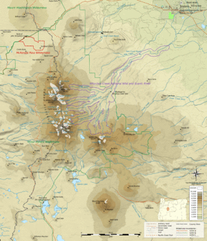
Mount Bachelor is part of a 15-mile (24 km) long chain of volcanoes. This chain includes Mount Bachelor itself, along with smaller cinder cones, lava flows, and three shield volcanoes. These volcanoes vary in size and shape. Some are steep cones from small explosions, while others are gently sloped shield volcanoes.
Understanding Mount Bachelor's Volcanic Type
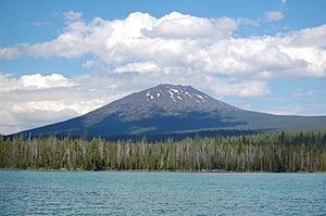
Mount Bachelor is a stratovolcano built on top of a shield volcano. It has a symmetrical shape. It formed between 18,000 and 8,000 years ago. The mountain is made of basalt and basaltic andesite, which are types of volcanic rock.
Glaciers have changed Mount Bachelor only a little. There's a small bowl-shaped valley called a cirque on its northern side, carved by a glacier. This glacier has shrunk a lot recently due to a warming climate. The top of the volcano has several vents that released lava flows. These eruptions were mostly gentle, not big explosions. There is no large crater at the summit.
Mount Bachelor last erupted between 10,000 and 8,000 years ago. Its surface is covered with ash from a huge eruption of Mount Mazama (which formed Crater Lake) about 6,845 years ago. Today, there's no heat coming from inside the volcano. Some spots that look like steam vents are just air moving through the rocky ground.
Nearby Volcanic Features
Mount Bachelor is surrounded by many smaller volcanic features. These include pyroclastic cones and shield volcanoes. Some nearby cones are Dry Butte, Egan Cone, and Talapus Butte. Shield volcanoes in the area include Sheridan Mountain and Lookout Mountain.
Mount Bachelor's Eruptive Past
The Mount Bachelor chain has been active during the last two major geological periods, the Pleistocene and Holocene. Most eruptions were slow flows of lava, with a few small explosions. These explosions created small cones made of scoria (bubbly volcanic rock) and threw out volcanic bombs.
The first eruptions happened about 18,000 to 15,000 years ago. At that time, a large glacier was melting in the area. Some early eruptions happened under this ice sheet, causing violent explosions. Later, milder eruptions created cones like Talapus and Katsuk Buttes.

The second period of eruptions created more scoria cones and lava flows south of Sheridan Mountain. The third period built the large shield volcano that forms the base of Mount Bachelor. Lava from Mount Bachelor flowed down its northern and northwestern sides. By 12,000 years ago, Mount Bachelor was almost its current size.
The mountain was mostly finished about 10,000 years ago. After that, there was a quiet period for 2,000 years. The most recent activity in the chain created the Egan cone on Mount Bachelor's lower northern side. Since the ash from Mount Mazama covers this area, no eruptions have likely happened in the last 7,700 years.
In total, the Mount Bachelor chain has produced a huge amount of volcanic material. Mount Bachelor itself accounts for about 25 cubic kilometers (6 cubic miles) of this material. Scientists believe this large volume was created in a short time, possibly as little as 1,500 years.
What if Mount Bachelor Erupts?
The United States Geological Survey says Mount Bachelor is a "moderate" threat. This means it's not likely to erupt in the near future. It might be a "monogenetic volcanic field," which means it had one long series of eruptions and then stopped forever. However, it could also just be sleeping and might erupt again.
If a volcano in the Bachelor chain were to erupt, it would mostly produce lava flows and ash. Lava flows move slowly, so people and animals can usually get out of the way. However, lava can block or change rivers, which could cause floods. An eruption would also greatly affect the ski area, putting visitors in danger. While an eruption is unlikely, it's something scientists keep an eye on.
Mount Bachelor's Story and Fun
Mount Bachelor got its name because it "stands apart" from the three other large volcanoes nearby, the Three Sisters. In the past, it was sometimes called "Brother Jonathan" or "Mount Brother."
Around World War II, many soldiers trained near Bend, Oregon. In 1941, a small ski area opened on Mount Bachelor. By 1958, it had grown into a full ski resort. The first chair lift was installed in 1962. The resort became very popular, attracting hundreds of thousands of visitors each year.
The people who developed the resort thought that skiing on a "butte" (a small hill) might sound less exciting. So, they named their resort Mount Bachelor. Over time, the ski area became so famous that the name Mount Bachelor became common. Eventually, the Oregon Geographic Names Board officially changed the mountain's name from Bachelor Butte to Mount Bachelor.
In 2013, the United States Forest Service approved plans to make the resort even better. These plans included a mountain bike park, more chair lifts, new trails, a zip line, and improved lodge buildings.
The very top of Mount Bachelor is home to the Mount Bachelor Observatory. This observatory is about 9,000 feet (2,743 meters) above sea level. Scientists use it to study air pollution that travels from Asia to the Pacific Northwest.
Fun Things to Do at Mount Bachelor
The Mount Bachelor ski area is a nationally known resort. It's one of the biggest in the Pacific Northwest. It has a huge area for skiing and snowboarding, about 3,683 acres (14.9 square kilometers). It also has six terrain parks for tricks and jumps.
This resort is a major center for winter fun in Deschutes County. It works with the United States Forest Service to offer activities while protecting the beautiful Oregon Cascades. Besides skiing and snowboarding, you can go snowshoeing, snow tubing, and dog sledding. They also offer tours with a naturalist to learn about local plants and animals.
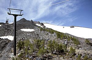
In the summer, the resort operates a chairlift to the summit, which is unique for a Cascade volcano. This means you can easily get to the top for amazing views! Fishing in the local lakes and streams is popular in summer, along with hiking and camping.
If you like to hike, you can climb to the top of Mount Bachelor. The trail starts at 6,300 feet (1,920 meters) and goes up 2,765 feet (843 meters) to the summit. The path goes over jagged lava rock from the volcano. From the top, you can see the entire Mount Bachelor chain to the south. You can also see other famous mountains like the Three Sisters, Mount Jefferson, Mount Hood, and even Mount Adams in Washington state.
 | Emma Amos |
 | Edward Mitchell Bannister |
 | Larry D. Alexander |
 | Ernie Barnes |


