Mount David (Washington) facts for kids
Quick facts for kids Mount David |
|
|---|---|

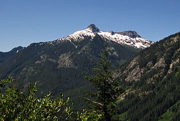
Mt. David centered, from the north
|
|
| Highest point | |
| Elevation | 7,420 ft (2,260 m) |
| Prominence | 2,420 ft (740 m) |
| Isolation | 5.69 mi (9.16 km) |
| Parent peak | Kololo Peaks (8,200+ ft) |
| Geography | |
| Location | Glacier Peak Wilderness Chelan County Washington state, U.S. |
| Parent range | North Cascades Cascade Range |
| Topo map | USGS Mount David |
| Type of rock | mica schist, quartzite, breccia |
| Climbing | |
| Easiest route | Hiking trail |
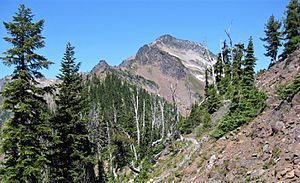
Mount David is a tall mountain in Chelan County, Washington state. It stands about 7,420 feet (2,262 meters) high. This mountain is part of the Glacier Peak Wilderness. It is managed by the Okanogan-Wenatchee National Forest.
Mount David is the highest point on Wenatchee Ridge. This ridge also includes other peaks like Indian Head Peak and Whittier Peak. The mountain is quite impressive because it rises 5,100 feet (1,554 meters) from the White River Valley in just two miles. Water from Mount David flows into the White River.
The mountain was named after the biblical David. It was named by Albert Hale Sylvester, a famous explorer and surveyor. He named many natural places in the Cascades. You can climb Mount David using a challenging seven-mile hiking trail. This trail gains over 5,000 feet (1,524 meters) in height.
Contents
Discovering Mount David's Geology
The North Cascades mountains have very rugged shapes. You can see sharp peaks, tall spires, and deep valleys carved by glaciers. These amazing shapes were created by geological events that happened millions of years ago. These events also caused big changes in height and climate across the Cascade Range.
How the Cascades Formed
The Cascade Mountains began forming millions of years ago. This was during a time called the late Eocene Epoch. The North American Plate was slowly moving over the Pacific Plate. This movement caused many volcanoes to erupt.
Glacier Peak is a large volcano about 11.8 miles (19 km) north of Mount David. It started forming in the mid-Pleistocene period. Because Glacier Peak is so close, you can find volcanic ash in the Mount David area. Also, small pieces of the Earth's crust, called terranes, helped create the North Cascades about 50 million years ago.
Ice and Earth Shaping the Land
During the Pleistocene period, which was over two million years ago, glaciers moved across the land. These glaciers repeatedly carved and shaped the landscape. The land was also pushed up and broken by faults. These processes, along with the glaciers, created the tall peaks and deep valleys we see in the North Cascades today.
Understanding Mount David's Climate
Most weather systems start over the Pacific Ocean. They then travel east towards the Cascade Mountains. As these weather systems reach the mountains, they are forced to rise. This causes them to drop their moisture as rain or snow onto the Cascades. This process is called Orographic lift.
Weather Patterns in the Cascades
Because of this, the Cascades get a lot of rain and snow. This is especially true during the winter months. In winter, the weather is often cloudy. However, in summer, high pressure systems form over the Pacific Ocean. These systems bring clear skies and little to no cloud cover. The best time to visit or climb Mount David is usually from July through September. The weather is most favorable during these months.
 | Claudette Colvin |
 | Myrlie Evers-Williams |
 | Alberta Odell Jones |


